Solomon Islands is a nation in the South Pacific Ocean, that lies east of Papua New Guinea.

The Oceanian realm is one of the World Wildlife Fund (WWF) biogeographic realms, and is unique in not including any continental land mass. It is the smallest in land of an area of the WWF realms.
Aldabra is the world's second-largest coral atoll. It is situated in the Aldabra Group of islands in the Indian Ocean that are part of the Outer Islands of the Seychelles, with a distance of 1,120 km (700 mi) southwest of the capital, Victoria, on Mahé Island.

The Coral Sea is a marginal sea of the South Pacific off the northeast coast of Australia, and classified as an interim Australian bioregion. The Coral Sea extends 2,000 kilometres (1,200 mi) down the Australian northeast coast. The sea was the location for the Battle of the Coral Sea, a major confrontation during World War II between the navies of the Empire of Japan, and the United States and Australia.
Sinharaja Forest Reserve is a forest reserve and a biodiversity hotspot in Sri Lanka. It is of international significance and has been designated a Biosphere Reserve and World Heritage Site by UNESCO.

Teraina (or Teeraina, also known as Washington Island is a coral atoll in the central Pacific Ocean and part of the Northern Line Islands which belong to Kiribati. Obsolete names of Teeraina are Prospect Island and New York Island. The island is located approximately 4.71° North latitude and 160.76° West longitude. Teeraina differs from most other atolls in the world in that it has a large freshwater lake, concealed within its luxuriant coconut palm forest; this is the only permanent freshwater lake in the whole of Kiribati.

Lake Ohrid is a lake which straddles the mountainous border between the southwestern part of North Macedonia and eastern Albania. It is one of Europe's deepest and oldest lakes, with a unique aquatic ecosystem of worldwide importance, with more than 200 endemic species.

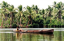
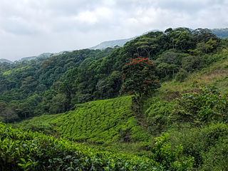
Rennell Island, locally known as Mugaba, is the main island of two inhabited islands that make up the Rennell and Bellona Province in the Solomon Islands. Rennell Island has a land area of 660 square kilometres (250 sq mi) that is about 80 kilometres (50 mi) long and 14 kilometres (8.7 mi) wide. It is the second largest raised coral atoll in the world with the largest lake in the insular Pacific, Lake Tegano, a lake that is listed as a World Heritage Site. Rennell Island has a population of about 1,840 persons of Polynesian descent who primarily speak Rennellese, Pijin and some English. Rennell and Bellona Islands are two of the few islands in the Melanesian Solomon Island archipelago classified as a Polynesian outlier; others being Sikaiana, Ontong Java, Tikopia, Anuta, Duff Islands, and some Reef Islands.

The Tropical Rainforest Heritage of Sumatra site was inscribed as a UNESCO World Heritage site in 2004. It comprises three Indonesian national parks on the island of Sumatra: Gunung Leuser National Park, Kerinci Seblat National Park and the Bukit Barisan Selatan National Park. The site is listed under Criteria vii - outstanding scenic beauty; ix- an outstanding example representing significant on-going ecological and biological processes; and x- contains the most important and significant natural habitats for in-situ conservation. The Tropical Rainforest Heritage of Sumatra has been placed on the Danger List since 2011 to help overcome threats posed by poaching, illegal logging, agricultural encroachment, and plans to build roads through the site.

The Papahānaumokuākea Marine National Monument is a World Heritage listed U.S. National Monument encompassing 583,000 square miles (1,510,000 km2) of ocean waters, including ten islands and atolls of the Northwestern Hawaiian Islands. Created in June 2006 with 140,000 square miles (360,000 km2), it was expanded in August 2016 by moving its border to the limit of the exclusive economic zone, making it one of the world's largest protected areas. It is internationally known for its cultural and natural values as follows:
"The area has deep cosmological and traditional significance for living Native Hawaiian culture, as an ancestral environment, as an embodiment of the Hawaiian concept of kinship between people and the natural world, and as the place where it is believed that life originates and to where the spirits return after death. On two of the islands, Nihoa and Makumanamana, there are archaeological remains relating to pre-European settlement and use. Much of the monument is made up of pelagic and deepwater habitats, with notable features such as seamounts and submerged banks, extensive coral reefs and lagoons."
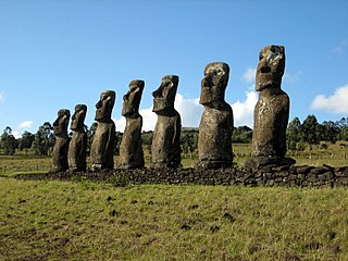
Rapa Nui National Park is a national park and UNESCO World Heritage Site located on Easter Island, Chile. Rapa Nui is the Polynesian name of Easter Island; its Spanish name is Isla de Pascua. The island is located in the southeastern Pacific Ocean, at the southeastern extremity of the Polynesian Triangle. The island was taken over by Chile in 1888. Its fame and World Heritage status arise from the 887 extant stone statues known by the name "moai", whose creation is attributed to the early Rapa Nui people who inhabited the island around 300 AD. Much of the island has been declared as Rapa Nui National Park which, on 22 March 1996, UNESCO designated a World Heritage Site under cultural criteria (i), (iii), & (v). The Rapa Nui National Park is now under the administrative control of the Ma´u Henua Polynesian Indigenous Community, which is the first autonomous institute on the island. The indigenous Rapa Nui people have regained authority over their ancestral lands and are in charge of the management, preservation and protection of their patrimony. On the first of December 2017, the ex-President Michelle Bachelet returned ancestral lands in the form of the Rapa Nui National Park to the indigenous people. For the first time in history, the revenue generated by the National Park is invested in the island and used to conserve the natural heritage.

The atoll fruit dove is a species of bird in the family Columbidae. It is endemic to the Tuamotu archipelago in French Polynesia. Its natural habitats are subtropical or tropical moist lowland forests and plantations. It is threatened by habitat loss.
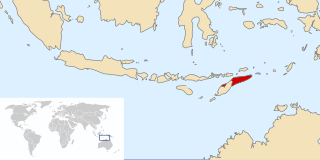
The Nino Konis Santana National Park is East Timor's first national park. The park, established on 15 August 2007, covers 1,236 square kilometres (477 sq mi). It links important bird areas such as Lore, Mount Paitchau, Lake Ira Lalaro, and Jaco Island. The park also includes 556 square kilometres (215 sq mi) of the Coral Triangle, an underwater area which supposedly contains the world's greatest diversity of both coral and coral reef fish. Some of the rare birds protected by this park are the critically endangered yellow-crested cockatoo, the endemic Timor green-pigeon, the endangered Timor imperial-pigeon, and the vulnerable Timor sparrow.

The Indispensable Reefs are a chain of three large coral atolls in the Coral Sea. They are located about 50 km (30 mi) south of Rennell Island, separated from it by Rennel Trough. The chain stretches over a length of 114 km (71 mi) and its average width is 18 km (11 mi).

Atol das Rocas Biological Reserve is a biological reserve in Brazil. The reserve is located on the Rocas Atoll, an atoll 144 miles north east of the Brazilian coast. It was created in 1979 to protect nesting sea turtles and migratory seabirds.

The Solomon Islands are an archipelago in the western South Pacific Ocean, located northeast of Australia. They are in the Melanesia subregion and bioregion of Oceania. The archipelago forms much of the territory of Solomon Islands, while the northwestern islands are within the Autonomous Region of Bougainville, in eastern Papua New Guinea. It forms the eastern boundary of the Solomon Sea.

Central Highlands of Sri Lanka is a recognised world Heritage Site in Sri Lanka. The site comprises the Peak Wilderness Protected Area, the Horton Plains National Park and the Knuckles Conservation Forest. These are rain forests, where the elevation reaches 2,500 metres (8,200 ft) above sea level. The region harbors a variety of mammal species including the bear monkey, Trachypithecus vetulus monticola, and the Horton Plains slender loris, Loris tardigradus nycticeboides,.

Half Moon Caye is an island and natural monument of Belize located at the southeast corner of Lighthouse Reef Atoll. This natural monument was the first nature reserve to have been established in Belize under the National Park Systems Act in 1981 and first marine protected area in Central America. This is also Belize's oldest site of wildlife protection since it was first designated as a bird sanctuary in 1924 to protect the habitat of the red-footed booby birds.