With a surface area of 5,800 square kilometres (2,200mi2), twice the size of Luxembourg, over a quarter the size of Wales, and larger than Delaware,[5] it was one of the largest recorded icebergs, the largest being B-15 which measured 11,000 square kilometres (4,200mi2) before breaking up. The calving of A-68 reduced the overall size of the Larsen C shelf by 12 percent.[5][6]
The name "A-68" was assigned by the US National Ice Center. It broke into parts with the mother berg dubbed A-68A. The larger child icebergs were designated in order of birthing, as A-68B, A-68C, A-68D, A-68E, A-68F, and in January 2021, splitting almost in half to birth A-68G. On 30 January 2021, Iceberg A-68A broke into other icebergs called A-68H, A-68I, A-68J, A-68K, A-68L, A-68M.
History and recent developments
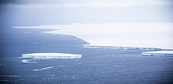
A-68 was part of LarsenC, a section of the Larsen Ice Shelf. Scientists found the crack beginning to form in November2016. Scientists assess that A-68 "didn't just break through in one clean shot, [but] it formed a lace-network of cracks first."[5] The resulting iceberg was around 175km (574,000ft) long and 50km (160,000ft) wide, 5,800km2 (2,200mi2) in area, 200m (660ft) thick and weighed an estimated one trillion tonnes.[8][5]
Satellite images from the ESA and EU's Copernicus Program show that as the iceberg moved, it was gradually shrinking and splintering, forming more icebergs in the process.[9]
Scientists were looking into the possibility of the ice shelf collapsing as a result of the split with A-68, or whether the iceberg was the "cork" for LarsenC that allows ice to flow more freely into the sea, thereby contributing to rising sea levels.[10]
Post November 2017, satellite images showed that A-68 was slowly drifting northward, with a widening gap to the main shelf. The gap was approximately five kilometers (3.1 miles) wide and contained a thin layer of loose, floating ice and a cluster of more than 11'smaller' bergs, one much larger than the others.[citation needed]
A British expedition on RRSJames Clark Ross intended to sample the marine life at the A-68 cleavage line in March2018, but had to turn back due to thick sea ice.[11] During 2018, A-68 continued to drift northwards.[12] In 2018 or 2019, a large chunk almost 14 km × 8 km (9 miles × 5 miles) broke off and was named A-68B, with the mother iceberg now being A-68A.[13]
On 6February 2020, A-68A began moving into open waters.[14] On 23April 2020, a chunk measuring about 175 sq. km.(70 sq. mi.) broke off the iceberg and was named A-68C.[15]
On 4November 2020, it was reported that A-68A was approaching South Georgia Island and that there was a strong possibility that the iceberg might run aground on the shallower continental shelf near the island, posing a grave threat to local penguins and seals.[16]
On 9December 2020, the Royal Air Force released video footage of A-68A, 150km off South Georgia. The RAF conducted reconnaissance flights over the iceberg on 18November and 5December 2020.[17]
As of 17December2020[update], a part of the iceberg was just 50km (31mi) from South Georgia, but the concern seemed to have lessened. National Geographic reported that "[s]cientists expect the iceberg ... to either anchor in the shallow waters around the island or move past it in the coming days."[18] On this date it was also reported that a corner had been knocked off A-68A, most likely due to impact with the seabed.[19] The new free floating iceberg was designated A-68D.[20]
On 22December 2020, images from ESA's Sentinel-1 radar satellite showed that A-68A had experienced a major break-up. Two of the larger fragments were named A-68E and A-68F.[21] A modeling study demonstrated that this break-up was likely triggered when part of A-68A became positioned within stronger ocean currents than the rest of the berg, generating enough tension along its body to break it into pieces.[22]
On 28January 2021, Sentinel-1 discovered that the southern third of A-68A had broken away. The new segment was named A-68G, with an area of around 950 square kilometres (370mi2). The imagery shows these two bergs around 135km south-east of South Georgia drifting close together.[23][24]
On 30January 2021, Iceberg A-68A broke up into other icebergs called A-68H, A-68I, A-68J, A-68K, A-68L, and A-68M.[25][26]
On 15February 2021, it was reported that British scientists had arrived at the remnants of A-68A, and had deployed a robotic glider to measure seawater salinity, temperature and chlorophyll close to the remaining blocks of ice to ascertain effects on local marine life.[27]
On 16April 2021, the largest fragment was down to 3nautical miles in length and the U.S.National Ice Center, which names, tracks, and documents Antarctic icebergs, discontinued tracking,[4] as the Center only studies icebergs that are at least 20sq. nautical miles, or that measure 10nautical miles on the longest axis.[28]
Gallery
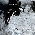
Radar imagery from Sentinel-1B taken on 12July 2017, showing the complete break
This page is based on this Wikipedia article Text is available under the CC BY-SA 4.0 license; additional terms may apply. Images, videos and audio are available under their respective licenses.