
The Pleistocene is the geological epoch that lasted from c. 2.58 million to 11,700 years ago, spanning the Earth's most recent period of repeated glaciations. Before a change was finally confirmed in 2009 by the International Union of Geological Sciences, the cutoff of the Pleistocene and the preceding Pliocene was regarded as being 1.806 million years Before Present (BP). Publications from earlier years may use either definition of the period. The end of the Pleistocene corresponds with the end of the last glacial period and also with the end of the Paleolithic age used in archaeology. The name is a combination of Ancient Greek πλεῖστος (pleîstos) 'most' and καινός 'new'.

The Quaternary is the current and most recent of the three periods of the Cenozoic Era in the geologic time scale of the International Commission on Stratigraphy (ICS), as well as the current and most recent of the twelve periods of the Phanerozoic eon. It follows the Neogene Period and spans from 2.58 million years ago to the present. The Quaternary Period is divided into two epochs: the Pleistocene and the Holocene ; a proposed third epoch, the Anthropocene, was rejected in 2024 by IUGS, the governing body of the ICS.

The Baltic Shield is a segment of the Earth's crust belonging to the East European Craton, representing a large part of Fennoscandia, northwestern Russia and the northern Baltic Sea. It is composed mostly of Archean and Proterozoic gneisses and greenstone which have undergone numerous deformations through tectonic activity. It contains the oldest rocks of the European continent with a thickness of 250–300 km.

The Last Glacial Period (LGP), also known as the Last glacial cycle, occurred from the end of the Last Interglacial to the beginning of the Holocene, c. 115,000 – c. 11,700 years ago, and thus corresponds to most of the timespan of the Late Pleistocene.
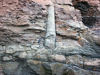
A polystrate fossil is a fossil of a single organism that extends through more than one geological stratum. The word polystrate is not a standard geological term. This term is typically found in creationist publications.
The Illinoian Stage is the name used by Quaternary geologists in North America to designate the Penultimate Glacial Period c.191,000 to c.130,000 years ago, during the late Middle Pleistocene (Chibanian), when sediments comprising the Illinoian Glacial Lobe were deposited. It precedes the Sangamonian Stage and follows the Pre-Illinoian Stage in North America. The Illinoian Stage is defined as the period of geologic time during which the glacial tills and outwash, which comprise the bulk of the Glasford Formation, accumulated to create the Illinoian Glacial Lobe.
The Yarmouthian stage and the Yarmouth Interglacial were part of a now-obsolete geologic timescale of the early Quaternary of North America.
An interglacial period is a geological interval of warmer global average temperature lasting thousands of years that separates consecutive glacial periods within an ice age. The current Holocene interglacial began at the end of the Pleistocene, about 11,700 years ago.

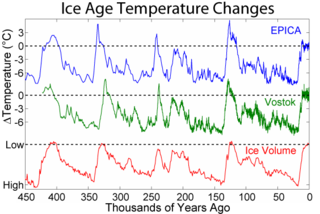
The Quaternary glaciation, also known as the Pleistocene glaciation, is an alternating series of glacial and interglacial periods during the Quaternary period that began 2.58 Ma and is ongoing. Although geologists describe this entire period up to the present as an "ice age", in popular culture this term usually refers to the most recent glacial period, or to the Pleistocene epoch in general. Since Earth still has polar ice sheets, geologists consider the Quaternary glaciation to be ongoing, though currently in an interglacial period.
The geology of the Netherlands describes the geological sequence of the Netherlands. Large parts of the Netherlands today are below sea level and have in the past been covered by the sea or flooded at regular intervals. The modern Netherlands formed as a result of the interplay of the four main rivers and the influence of the North Sea and glaciers during ice-ages. The Netherlands is mostly composed of deltaic, coastal and eolian derived sediments during the Pleistocene glacial and interglacial periods.
The Ancestral Thames is the geologically ancient precursor to the present day River Thames. The river has its origins in the emergence of Britain from a Cretaceous sea over 60 million years ago. Parts of the river's course were profoundly modified by the Anglian glaciation some 450,000 years ago. The extensive terrace deposits laid down by the Ancestral Thames over the past two million years or so have provided a rich source of material for studies in geology, geomorphology, palaeontology and archaeology.

The Holstein or Holsteinian interglacial, also called the Mindel-Riss interglacial (Mindel-Riß-Interglazial) in the Alpine region, is the third to last major interglacial in Europe before the Holocene, the present warm period. It followed directly after the Elster glaciation and came before the Saale glaciation, during the Middle Pleistocene. The more precise timing was historically controversial since Holstein was commonly correlated to two different marine isotope stages, MIS 11 and MIS 9. Recent scholarship has supported a MIS 11 date, spanning approximately 421-395,000 years ago.
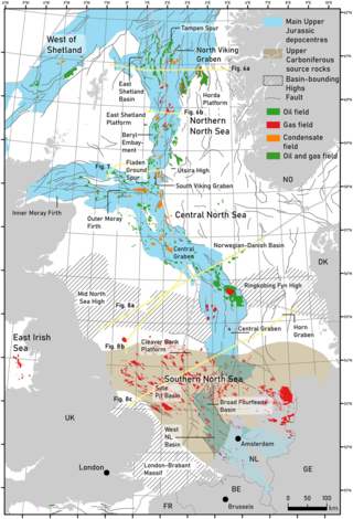
The geology of the North Sea describes the geological features such as channels, trenches, and ridges today and the geological history, plate tectonics, and geological events that created them.
The Sangamonian Stage is the term used in North America to designate the Last Interglacial and depending on definition, part of the early Last Glacial Period, corresponding to Marine Isotope Stage 5. While often historically considered equivalent in scope to MIS 5, it is now often used in a more narrow sense to refer to the Last Interglacial only. It preceded the Wisconsinan (Wisconsin) Stage and followed the Illinoian Stage in North America.

The Weichselian glaciation is the regional name for the Last Glacial Period in the northern parts of Europe. In the Alpine region it corresponds to the Würm glaciation. It was characterized by a large ice sheet that spread out from the Scandinavian Mountains and extended as far as the east coast of Schleswig-Holstein, northern Poland and Northwest Russia. This glaciation is also known as the Weichselian ice age, Vistulian glaciation, Weichsel or, less commonly, the Weichsel glaciation, Weichselian cold period (Weichsel-Kaltzeit), Weichselian glacial (Weichsel-Glazial), Weichselian Stage or, rarely, the Weichselian complex (Weichsel-Komplex).
The geology of the Baltic Sea is characterized by having areas located both at the Baltic Shield of the East European Craton and in the Danish-North German-Polish Caledonides. Historical geologists make a distinction between the current Baltic Sea depression, formed in the Cenozoic era, and the much older sedimentary basins whose sediments are preserved in the zone. Although glacial erosion has contributed to shape the present depression, the Baltic trough is largely a depression of tectonic origin that existed long before the Quaternary glaciation.

The geology of Germany is heavily influenced by several phases of orogeny in the Paleozoic and the Cenozoic, by sedimentation in shelf seas and epicontinental seas and on plains in the Permian and Mesozoic as well as by the Quaternary glaciations.
The geology of Estonia is the study of rocks, minerals, water, landforms and geologic history in Estonia. The crust is part of the East European Craton and formed beginning in the Paleoproterozoic nearly two billion years ago. Shallow marine environments predominated in Estonia, producing extensive natural resources from organic matter such as oil shale and phosphorite. The Mesozoic and much of the Cenozoic are not well-preserved in the rock record, although the glaciations during the Pleistocene buried deep valleys in sediment, rechanneled streams and left a landscape of extensive lakes and peat bogs.
Geology of Latvia includes an ancient Archean and Proterozoic crystalline basement overlain with Neoproterozoic volcanic rocks and numerous sedimentary rock sequences from the Paleozoic, some from the Mesozoic and many from the recent Quaternary past. Latvia is a country in the Baltic region of Northern Europe.
The geology of Denmark includes 12 kilometers of unmetamorphosed sediments lying atop the Precambrian Fennoscandian Shield, the Norwegian-Scottish Caledonides and buried North German-Polish Caledonides. The stable Fennoscandian Shield formed from 1.45 billion years ago to 850 million years ago in the Proterozoic. The Fennoscandian Border Zone is a large fault, bounding the deep basement rock of the Danish Basin—a trough between the Border Zone and the Ringkobing-Fyn High. The Sorgenfrei-Tornquist Zone is a fault-bounded area displaying Cretaceous-Cenozoic inversion.
