A seamount is a large geologic landform that rises from the ocean floor but that does not reach to the water's surface, and thus is not an island, islet or cliff-rock. Seamounts are typically formed from extinct volcanoes that rise abruptly and are usually found rising from the seafloor to 1,000–4,000 m (3,300–13,100 ft) in height. They are defined by oceanographers as independent features that rise to at least 1,000 m (3,281 ft) above the seafloor, characteristically of conical form. The peaks are often found hundreds to thousands of meters below the surface, and are therefore considered to be within the deep sea. During their evolution over geologic time, the largest seamounts may reach the sea surface where wave action erodes the summit to form a flat surface. After they have subsided and sunk below the sea surface such flat-top seamounts are called "guyots" or "tablemounts".
Hydrothermal circulation in its most general sense is the circulation of hot water. Hydrothermal circulation occurs most often in the vicinity of sources of heat within the Earth's crust. In general, this occurs near volcanic activity, but can occur in the deep crust related to the intrusion of granite, or as the result of orogeny or metamorphism.

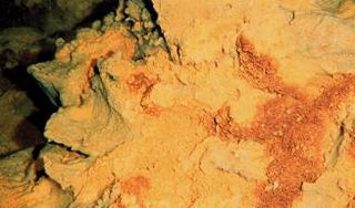
A hydrothermal vent is a fissure on the seafloor from which geothermally heated water discharges. Hydrothermal vents are commonly found near volcanically active places, areas where tectonic plates are moving apart at spreading centers, ocean basins, and hotspots. Hydrothermal deposits are rocks and mineral ore deposits formed by the action of hydrothermal vents.

Riftia pachyptila, commonly known as the giant tube worm, is a marine invertebrate in the phylum Annelida related to tube worms commonly found in the intertidal and pelagic zones. R. pachyptila lives on the floor of the Pacific Ocean near hydrothermal vents, and can tolerate extremely high hydrogen sulfide levels. These worms can reach a length of 3 m, and their tubular bodies have a diameter of 4 cm (1.6 in). Ambient temperature in their natural environment ranges from 2 to 30°C.

Lōʻihi Seamount is an active submarine volcano about 22 mi (35 km) off the southeast coast of the island of Hawaii. The top of the seamount is about 3,200 ft (975 m) below sea level. This seamount is on the flank of Mauna Loa, the largest shield volcano on Earth. Lōʻihi, meaning "long" in Hawaiian, is the newest volcano in the Hawaiian–Emperor seamount chain, a string of volcanoes that stretches about 3,900 mi (6,200 km) northwest of Lōʻihi. Unlike most active volcanoes in the Pacific Ocean that make up the active plate margins on the Pacific Ring of Fire, Lōʻihi and the other volcanoes of the Hawaiian–Emperor seamount chain are hotspot volcanoes and formed well away from the nearest plate boundary. Volcanoes in the Hawaiian Islands arise from the Hawaii hotspot, and as the youngest volcano in the chain, Lōʻihi is the only Hawaiian volcano in the deep submarine preshield stage of development.

The Lost City Hydrothermal Field, often referred to simply as Lost City, is an area of marine alkaline hydrothermal vents located on the Atlantis Massif at the intersection between the Mid-Atlantic Ridge and the Atlantis Transform Fault, in the Atlantic Ocean. It is a long-lived site of active and inactive ultramafic-hosted serpentinization, abiotically producing many simple molecules such as methane and hydrogen which are fundamental to microbial life. As such it has generated scientific interest as a prime location for investigating the origin of life on Earth and other planets similar to it.

The Juan de Fuca Ridge is a mid-ocean spreading center and divergent plate boundary located off the coast of the Pacific Northwest region of North America. The ridge separates the Pacific Plate to the west and the Juan de Fuca Plate to the east. It runs generally northward, with a length of approximately 500 kilometers. The ridge is a section of what remains from the larger Pacific-Farallon Ridge which used to be the primary spreading center of this region, driving the Farallon Plate underneath the North American Plate through the process of plate tectonics. Today, the Juan de Fuca Ridge pushes the Juan de Fuca Plate underneath the North American plate, forming the Cascadia Subduction Zone.
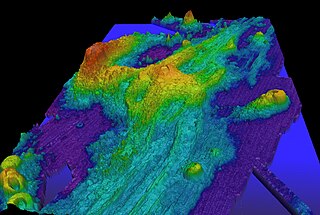
Axial Seamount is a seamount and submarine volcano located on the Juan de Fuca Ridge, approximately 480 km (298 mi) west of Cannon Beach, Oregon. Standing 1,100 m (3,609 ft) high, Axial Seamount is the youngest volcano and current eruptive center of the Cobb–Eickelberg Seamount chain. Located at the center of both a geological hotspot and a mid-ocean ridge, the seamount is geologically complex, and its origins are still poorly understood. Axial Seamount is set on a long, low-lying plateau, with two large rift zones trending 50 km (31 mi) to the northeast and southwest of its center. The volcano features an unusual rectangular caldera, and its flanks are pockmarked by fissures, vents, sheet flows, and pit craters up to 100 m (328 ft) deep; its geology is further complicated by its intersection with several smaller seamounts surrounding it.

The Izu–Bonin–Mariana (IBM) arc system is a tectonic plate convergent boundary. The IBM arc system extends over 2800 km south from Tokyo, Japan, to beyond Guam, and includes the Izu Islands, the Bonin Islands, and the Mariana Islands; much more of the IBM arc system is submerged below sealevel. The IBM arc system lies along the eastern margin of the Philippine Sea Plate in the Western Pacific Ocean. It is the site of the deepest gash in Earth's solid surface, the Challenger Deep in the Mariana Trench.
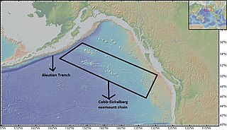
The Cobb-Eickelberg seamount chain is a range of undersea mountains formed by volcanic activity of the Cobb hotspot located in the Pacific Ocean. The seamount chain extends to the southeast on the Pacific Plate, beginning at the Aleutian Trench and terminating at Axial Seamount, located on the Juan de Fuca Ridge.The seamount chain is spread over a vast length of approximately 1800 km. The location of the Cobb hotspot that gives rise to these seamounts is 46° N -130° W. The Pacific plate is moving to the northwest over the hotspot, causing the seamounts in the chain to decrease in age to the southeast. Axial is the youngest seamount and is located approximately 480 km west of Cannon Beach, Oregon. The most studied seamounts that make up this chain are Axial, Brown Bear, Cobb, and Patton seamounts. There are many other seamounts in this chain which have not been explored.

Symphurus thermophilus is a species of tonguefish notable for being the only flatfish known to be an obligate inhabitant of hydrothermal vents. It is known from several widely dispersed locations in the western Pacific Ocean and occurs in great numbers. They are tolerant of harsh conditions and are often found in close association with elemental sulfur, including molten sulfur pools that exceed 180 °C in temperature. As they are not significantly different in appearance and feeding habits from other tonguefishes, they are thought to be relatively recent colonizers of vent ecosystems.

Suiyo Seamount is a seamount off the eastern coast of Japan, directly south of Torishima and Sofugan volcano at the southern tip of the Izu Islands. The volcano is one of the Shichiyo Seamounts, a small group of submarine volcanoes named after different days of the week.
The class Zetaproteobacteria is the sixth and most recently described class of the Proteobacteria. Zetaproteobacteria can also refer to the group of organisms assigned to this class. The Zetaproteobacteria were originally represented by a single described species, Mariprofundus ferrooxydans, which is an iron-oxidizing neutrophilic chemolithoautotroph originally isolated from Loihi Seamount in 1996 (post-eruption). Molecular cloning techniques focusing on the small subunit ribosomal RNA gene have also been used to identify a more diverse majority of the Zetaproteobacteria that have as yet been unculturable.
Ocean Networks Canada is a University of Victoria initiative that operates the NEPTUNE and VENUS cabled ocean observatories in the northeast Pacific Ocean and the Salish Sea. Additionally, Ocean Networks Canada operates smaller community-based observatories offshore from Cambridge Bay, Nunavut., Campbell River, Kitamaat Village and Digby Island. These observatories collect data on physical, chemical, biological, and geological aspects of the ocean over long time periods. As with other ocean observatories such as ESONET, Ocean Observatories Initiative, MACHO and DONET, scientific instruments connected to Ocean Networks Canada are operated remotely and provide continuous streams of freely available data to researchers and the public. Over 200 gigabytes of data are collected every day.
Monowai is a volcanic seamount to the north of New Zealand. It is formed by a large caldera and a volcanic cone just south-southeast from the caldera. The volcanic cone rises to depths of up to 100 metres (330 ft) but its depth varies with ongoing volcanic activity, including sector collapses and the growth of lava domes. The seamount and its volcanism were discovered after 1877, but only in 1980 was it named "Monowai" after a research ship of the same name.

Vailuluʻu is a volcanic seamount discovered in 1975. It rises from the sea floor to a depth of 593 m (1,946 ft) and is located between Taʻu and Rose islands at the eastern end of the Samoa hotspot chain. The basaltic seamount is considered to mark the current location of the Samoa hotspot. The summit of Vailuluʻu contains a 2 km wide, 400 m deep oval-shaped caldera. Two principal rift zones extend east and west from the summit, parallel to the trend of the Samoan hotspot. A third less prominent rift extends southeast of the summit.

NW Rota-1 is a seamount in the Mariana Islands, northwest of Rota, which was discovered through its hydrothermal activity in 2003. The volcano has been observed to be erupting underwater, the first time that submarine explosive eruptions have been directly witnessed.

Henry Seamount is a seamount of Cretaceous age southeast of El Hierro in the Canary Islands. It is 660 metres (2,170 ft) high above the seafloor and covered with sediments. Despite its old age, it shows evidence of recent eruptions and of hydrothermal activity in the last 3,350 years. This activity may be either mediated by groundwater flow from El Hierro or by recent eruptions of Henry Seamount.
Kemp Caldera and Kemp Seamount form a submarine volcano south of the South Sandwich Islands, in a region where several seamounts are located. The seamount rises to a depth of 80 metres (260 ft) below sea level; the caldera has a diameter of 8.3 by 6.5 kilometres and reaches a depth of 1,600 metres (5,200 ft). The caldera contains several Hydrothermal vents, including white smokers and diffuse venting areas, which are host to chemolithotrophic ecological communities. The seamount and caldera, which were discovered by seafloor mapping in 2009, are part of the South Georgia and the South Sandwich Islands Marine Protected Area.

Eifuku and NW Eifuku are two seamounts in the Pacific Ocean. The better known one is NW Eifuku, where an unusual hydrothermal vent called "Champagne" produced droplets of liquid CO
2. Both seamounts are located in the Northern Marianas and are volcanoes, part of the Izu-Bonin-Mariana Arc. NW Eifuku rises to 1,535 metres (5,036 ft) depth below sea level and is a 9 kilometres (5.6 mi) wide volcanic cone.