
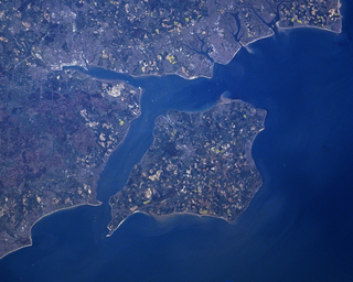
Portsmouth is a port city and unitary authority in Hampshire, England. Most of Portsmouth is located on Portsea Island, off the south coast of England in the Solent. This means Portsmouth is the only English city not located primarily on the mainland. Located 74 miles (119 km) south-west of London and 22 miles (35 km) south-east of Southampton; Portsmouth is part of the South Hampshire conurbation. It is the most densely populated city in the United Kingdom, with a population last recorded at 208,100.
The Solent is a strait between the Isle of Wight and mainland Great Britain. It is about 20 miles long and varies in width between 2+1⁄2 and 5 mi, although the Hurst Spit which projects 1+1⁄2 mi (2.4 km) into the Solent narrows the sea crossing between Hurst Castle and Colwell Bay to just over 1 mi (1.6 km).

Port Jackson, consisting of the waters of Sydney Harbour, Middle Harbour, North Harbour and the Lane Cove and Parramatta Rivers, is the ria or natural harbour of Sydney, New South Wales, Australia. The harbour is an inlet of the Tasman Sea. It is the location of the Sydney Opera House and Sydney Harbour Bridge. The location of the first European settlement and colony on the Australian mainland, Port Jackson has continued to play a key role in the history and development of Sydney.

Gosport is a town and non-metropolitan borough, on the south coast of Hampshire, South East England. At the 2021 Census, its population was 81,952. Gosport is situated on a peninsula on the western side of Portsmouth Harbour, opposite the city of Portsmouth, to which it is linked by the Gosport Ferry. Gosport lies south-east of Fareham, to which it is linked by a Bus Rapid Transit route and the A32. Until the last quarter of the 20th century, Gosport was a major naval town associated with the defence and supply infrastructure of His Majesty's Naval Base (HMNB) Portsmouth. As such over the years extensive fortifications were created.

The fortifications of Portsmouth are extensive due to its strategic position on the English Channel and role as home to the Royal Navy. For this reason, Portsmouth was, by the 19th century, one of the most fortified cities in the world. The fortifications have evolved over the centuries in response to changes in tactics and technology and the area defended has increased. While the first defences focused on Portsmouth harbour, in step with the fortifications of Gosport, later defensive structures protected the whole of Portsea Island and an increasing distance inland. At the same time, the fortifications of Portsmouth and Gosport became part of the wider fortifications of the Solent. Old Portsmouth, on the southwest corner of Portsea Island, has been walled for much of its history.

The Hilsea Lines are a line of 18th- and 19th-century fortifications built at Hilsea to protect the northern approach to Portsea Island, an island off the southern coast of England which forms the majority of the city of Portsmouth and its key naval base. They are now used as a greenspace and leisure area, also known locally as Foxes Forest.

Portsea Island is a flat and low-lying natural island 24.5 square kilometres in area, just off the southern coast of Hampshire in England. Portsea Island contains the majority of the city of Portsmouth.

A tidal island is a piece of land that is connected to the mainland by a natural or man-made causeway that is exposed at low tide and submerged at high tide. Because of the mystique surrounding tidal islands, many of them have been sites of religious worship, such as Mont-Saint-Michel with its Benedictine Abbey. Tidal islands are also commonly the sites of fortresses because of their natural fortifications.
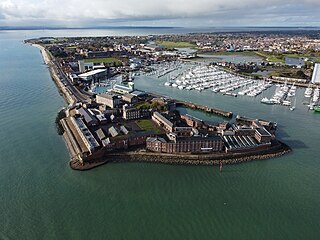
Fort Blockhouse is a military establishment in Gosport, Hampshire, England, and the final version of a complicated site. At its greatest extent in the 19th century, the structure was part of a set of fortifications which encircled much of Gosport. It is surrounded on three sides by water and provides the best view of the entrance to Portsmouth Harbour. It is unique in two respects. Firstly, it was built over five centuries from its original construction as a blockhouse in 1431 to the final addition of submarine base structures in the mid-1960s. Secondly, it is thought to be the oldest fortified position in the United Kingdom that is still in active military use though coastal fortification was abolished nationally in 1956, and it has been used only for medical purposes since 2020.

Fort Cumberland is a pentagonal artillery fortification erected to guard the entrance to Langstone Harbour, east of the Dockyard of Portsmouth on the south coast of England. It was sited to protect the Royal Navy Dockyard, by preventing enemy forces from landing in Langstone Harbour and attacking from the landward side. Fort Cumberland is widely recognised as the finest example of a bastion trace fort in England. It is a scheduled monument and a Grade II* listed building

Portsmouth Harbour is a 1,264.2-hectare (3,124-acre) biological Site of Special Scientific Interest between Portsmouth and Gosport in Hampshire. It is a Ramsar site and a Special Protection Area.

Portsmouth Point, or "Spice Island", is part of Old Portsmouth in Portsmouth, Hampshire, on the southern coast of England. The name Spice Island comes from the area's seedy reputation, as it was known as the "Spice of Life". Men were easily found and press-ganged into Nelson's navy from Portsmouth Point due to its hostelries and for being where prostitutes plied their trade. The area forms the eastern side of the narrow entrance to Portsmouth Harbour, facing Gosport on the western side.
Portsmouth is an island port city situated on Portsea Island in the county of Hampshire, England. Its history has been influenced by its association with the sea, and its proximity to London, and mainland Europe.
The Gosport and Cosham lines were a collection of railway lines in southern Hampshire. Most of the lines are now closed but some elements are still in use, forming part of the West Coastway line. The lines originally linked to the main London to Southampton line via the Eastleigh–Fareham line and subsequently with a line from Southampton via Bursledon, both of which are still in use.

Portsbridge Creek, known officially as Portsea Creek and informally as Ports Creek, Port Creek, Portcreek and Canal Creek,, is a tidal waterway just off the southern coast of England that runs between Portsea Island and the mainland from Langstone Harbour to Tipner Lake.

Lumps Fort is a disused fortification built on Portsea Island as part of the defences for the naval base at Portsmouth.

The Stokes Bay Lines were part of the great Victorian fortification of Portsmouth Harbour under Lord Palmerston. In 1857 Major Jervois had proposed a complex system of moats (ditches), ramparts and batteries to close off the gap between the new fort at Fort Gomer, and the earlier fort at Fort Gilkicker, and Fort Monckton. This defensive moat was to become the ‘Stokes Bay Lines’.
The siege of Portsmouth was the siege of a Royalist garrison in Portsmouth by a Parliamentarian force conducted in the early part of the First English Civil War. The siege resulted in Portsmouth falling to Parliament after a little under a month of conflict.

Fort Monckton is a historic military fort on the south-east shoreline of the Gosport peninsula, Hampshire. Built on the ruins of Haselworth Castle to protect Portsmouth Harbour at the start of the American War of Independence, it was rebuilt in the 1880s as a Palmerston fort.
Defence Munitions Gosport is a defence munitions site situated on the southwestern shores of Portsmouth harbour, southeast of Fareham in Hampshire, England. The site occupies about 470 acres. Its facilities include two Integrated Weapon Complexes (IWCs), 24 processing rooms and 26 explosives stores. The site employs some 270 staff.


