
Oceanic trenches are topographic depressions of the seafloor, relatively narrow in width, but very long. These oceanographic features are the deepest parts of the ocean floor. Oceanic trenches are a distinctive morphological feature of convergent plate boundaries, along which lithospheric plates move towards each other at rates that vary from a few millimeters to over ten centimeters per year. A trench marks the position at which the flexed, subducting slab begins to descend beneath another lithospheric slab. Trenches are generally parallel to a volcanic island arc, and about 200 km (120 mi) from a volcanic arc. Oceanic trenches typically extend 3 to 4 km below the level of the surrounding oceanic floor. The greatest ocean depth measured is in the Challenger Deep of the Mariana Trench, at a depth of 11,034 m (36,201 ft) below sea level. Oceanic lithosphere moves into trenches at a global rate of about 3 km2/yr.
A volcanic arc is a chain of volcanoes formed above a subducting plate, positioned in an arc shape as seen from above. Offshore volcanoes form islands, resulting in a volcanic island arc. Generally, volcanic arcs result from the subduction of an oceanic tectonic plate under another tectonic plate, and often parallel an oceanic trench. The oceanic plate is saturated with water, and volatiles such as water drastically lower the melting point of the mantle. As the oceanic plate is subducted, it is subjected to greater and greater pressures with increasing depth. This pressure squeezes water out of the plate and introduces it to the mantle. Here the mantle melts and forms magma at depth under the overriding plate. The magma ascends to form an arc of volcanoes parallel to the subduction zone.

The Scotia Plate is a tectonic plate on the edge of the South Atlantic and Southern oceans. Thought to have formed during the early Eocene with the opening of the Drake Passage that separates South America from Antarctica, it is a minor plate whose movement is largely controlled by the two major plates that surround it: the South American Plate and the Antarctic Plate.

The Aleutian Trench is an oceanic trench along a convergent plate boundary which runs along the southern coastline of Alaska and the Aleutian islands. The trench extends for 3,400 kilometres (2,100 mi) from a triple junction in the west with the Ulakhan Fault and the northern end of the Kuril–Kamchatka Trench, to a junction with the northern end of the Queen Charlotte Fault system in the east. It is classified as a "marginal trench" in the east as it runs along the margin of the continent. The subduction along the trench gives rise to the Aleutian Arc, a volcanic island arc, where it runs through the open sea west of the Alaska Peninsula. As a convergent plate boundary, the trench forms part of the boundary between two tectonic plates. Here, the Pacific Plate is being subducted under the North American Plate at a dip angle of nearly 45°. The rate of closure is 7.5 centimetres (3 in) per year.

The Izu–Bonin–Mariana (IBM) arc system is a tectonic plate convergent boundary. The IBM arc system extends over 2800 km south from Tokyo, Japan, to beyond Guam, and includes the Izu Islands, the Bonin Islands, and the Mariana Islands; much more of the IBM arc system is submerged below sealevel. The IBM arc system lies along the eastern margin of the Philippine Sea Plate in the Western Pacific Ocean. It is the site of the deepest gash in Earth's solid surface, the Challenger Deep in the Mariana Trench.
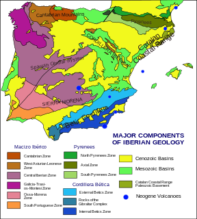
The geology of the Iberian Peninsula consists of the study of the rock formations on the Iberian Peninsula, which includes Spain, Portugal, Andorra, and Gibraltar. The peninsula contains rocks from every geological period from the Ediacaran to the Quaternary, and many types of rock are represented. World-class mineral deposits are also found there.

The Mariana Trough is an active back-arc basin in the western Pacific Ocean. It is an integral part of the Izu–Bonin–Mariana Arc system.

The Hampshire Basin is a geological basin of Palaeogene age in southern England, underlying parts of Hampshire, the Isle of Wight, Dorset, and Sussex. Like the London Basin to the northeast, it is filled with sands and clays of Paleocene and younger ages and it is surrounded by a broken rim of chalk hills of Cretaceous age.

The Aleutian Basin is an oceanic basin under the southwestern Bering Sea. While the northeastern half of the Bering Sea overlies the North American Plate in relatively shallow water, the Aleutian Basin consists of oceanic plate—the remnant of the Kula Plate that was mostly subducted under the North American Plate.

The Aleutian Islands, also called the Aleut Islands or Aleutic Islands and known before 1867 as the Catherine Archipelago, are a chain of 14 large volcanic islands and 55 smaller islands. Most of the Aleutian Islands belong to the U.S. state of Alaska, but some belong to the Russian federal subject of Kamchatka Krai. They form part of the Aleutian Arc in the Northern Pacific Ocean, occupying an area of 6,821 sq mi (17,666 km2) and extending about 1,200 mi (1,900 km) westward from the Alaska Peninsula toward the Kamchatka Peninsula in Russia, and act as a border between the Bering Sea to the north and the Pacific Ocean to the south. Crossing longitude 180°, at which point east and west longitude end, the archipelago contains both the westernmost part of the United States by longitude and the easternmost by longitude. The westernmost U.S. island in real terms, however, is Attu Island, west of which runs the International Date Line. While nearly all the archipelago is part of Alaska and is usually considered as being in the "Alaskan Bush", at the extreme western end, the small, geologically related Commander Islands belong to Russia.

The Andean orogeny is an ongoing process of orogeny that began in the Early Jurassic and is responsible for the rise of the Andes mountains. The orogeny is driven by a reactivation of a long-lived subduction system along the western margin of South America. On a continental scale the Cretaceous and Oligocene were periods of re-arrangements in the orogeny. Locally the details of the nature of the orogeny varies depending on the segment and the geological period considered.

The geology of Russia, the world's largest country, which extends over much of northern Eurasia, consists of several stable cratons and sedimentary platforms bounded by orogenic (mountain) belts.
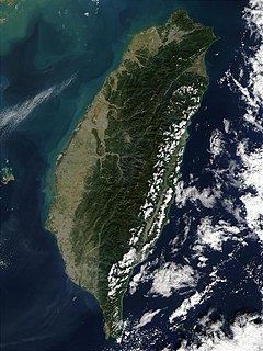
The island of Taiwan is active geologically, formed on a complex convergent boundary between the Yangtze Subplate of the Eurasian Plate to the west and north, the Okinawa Plate on the north-east, the Philippine Plate on the east and south, and the Sunda Plate to the southwest. Subduction changes direction at Taiwan. The upper part of the crust on the island is primarily made up of a series of terranes, mostly old island arcs which have been forced together by the collision of the forerunners of the Eurasian Plate and the Philippine Sea Plate, which is moving to the northwest. These have been further uplifted as a result of the detachment of a portion of the Eurasian Plate as it was subducted beneath remnants of the Philippine Sea Plate, a process which left the crust under Taiwan more buoyant.

The Shirshov Ridge is located on the eastern border of the Commander Basin below the Kamchatka Peninsula. It extends directly southward for a distance of 750 km toward the Aleutian arc in the eastern part of the Bering Sea.
The Commander Basin is located between the Shirshov Ridge and the Kamchatka Peninsula. Its southern boundary is the Aleutian arc and occupies the western part of the Bering Sea. The Kamchatka Strait provides a deep water access to the basin from the southwest.

The El Tigre Fault is a 120 km long, roughly north-south trending, major strike-slip fault located in the Western Precordillera in Argentina. The Precordillera lies just to the east of the Andes mountain range in South America. The northern boundary of the fault is the Jáchal River and its southern boundary is the San Juan River. The fault is divided into three sections based on fault trace geometry, Northern extending between 41–46 km in length, Central extending between 48–53 km in length, and Southern extending 26 km in length. The fault displays a right-lateral (horizontal) motion and has formed in response to stresses from the Nazca Plate subducting under the South American Plate. It is a major fault with crustal significance. The Andes Mountain belt trends with respect to the Nazca Plate/South American Plate convergence zone, and deformation is divided between the Precordilleran thrust faults and the El Tigre strike-slip motion. The El Tigre Fault is currently seismically active.

The offshore Indus Basin is one of the two basins in offshore Pakistan, the other one being the offshore Makran Basin. The Murray Ridge separates the two basins. The offshore Indus basin is approximately 120 to 140 kilometers wide and has an areal extent of ~20,000 square km.

The North Fiji Basin (NFB) is an oceanic basin west of Fiji in the south-west Pacific Ocean. It is an actively spreading back-arc basin delimited by the Fiji islands to the east, the inactive Vitiaz Trench to the north, the Vanuatu/New Hebrides island arc to the west, and the Hunter fracture zone to the south. Roughly triangular in shape with its apex located at the northern end of the New Hebrides Arc, the basin is actively spreading southward and is characterised by three spreading centres and an oceanic crust younger than 12 Ma. The opening of the NFB began when a slab roll-back was initiated beneath the New Hebrides and the island arc started its clockwise rotation. The opening of the basin was the result of the collision between the Ontong Java Plateau and the Australian Plate along the now inactive Solomon–Vitiaz subduction system north of the NFB. The NFB is the largest and most developed back-arc basin of the south-west Pacific. It is opening in a complex geological setting between two oppositely verging subduction systems, the New Hebrides/Vanuatu and Tonga trenches and hence its ocean floor has the World's largest amount of spreading centres per area.
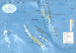
The d'EntrecasteauxRidge (DER) is a double oceanic ridge in the south-west Pacific Ocean, north of New Caledonia and west of Vanuatu Islands. It forms the northern extension of the New Caledonia–Loyalty Islands arc, and is now actively subducting under the Vanuatu/New Hebrides arc. The subduction of the DER is responsible for the anomalous morphology of the central part of New Hebrides arc whose movement more closely matches the north-east direction of the subducting Australian Plate.
The Aleutian subduction zone is a ~2500 mile-long convergence boundary between the North American Plate and the Pacific Plate, that extends from the Alaska Range to the Kamchatka Peninsula. Here, the Pacific Plate is being subducted underneath the North American plate and the rate of subduction changes from west to east from 7.5 cm/yr to 5.1 cm/yr. The Aleutian subduction zone includes two prominent features, the Aleutian arc and the Aleutian trench. The island arc was created via volcanic eruptions from dehydration of the subducting slab at ~100 km depth. The trench is a narrow and deep morphology that occurs between the two converging plates as the subducting slab dives beneath the overriding plate.
