In marine geology, a guyot, also known as a tablemount, is an isolated underwater volcanic mountain (seamount) with a flat top more than 200 m (660 ft) below the surface of the sea. The diameters of these flat summits can exceed 10 km (6.2 mi). Guyots are most commonly found in the Pacific Ocean, but they have been identified in all the oceans except the Arctic Ocean.

A seamount is a large geologic landform that rises from the ocean floor but that does not reach to the water's surface, and thus is not an island, islet or cliff-rock. Seamounts are typically formed from extinct volcanoes that rise abruptly and are usually found rising from the seafloor to 1,000–4,000 m (3,300–13,100 ft) in height. They are defined by oceanographers as independent features that rise to at least 1,000 m (3,281 ft) above the seafloor, characteristically of conical form. The peaks are often found hundreds to thousands of meters below the surface, and are therefore considered to be within the deep sea. During their evolution over geologic time, the largest seamounts may reach the sea surface where wave action erodes the summit to form a flat surface. After they have subsided and sunk below the sea surface such flat-top seamounts are called "guyots" or "tablemounts".
The Zhongsha Islets is a Chinese term for a collection of two skerries, many entirely submerged banks, seamounts, and shoals in the South China Sea. There are in fact, no islands in the Macclesfield Bank, the main part of Zhongsha. The Scarborough Shoal, which consists of two skerries, is not contiguous with the Macclesfield Bank but Chinese sources treat them as one chain of geographical features. The whole of the region is claimed by both the PRC and the ROC, and various bits of the eastern parts are claimed by the Philippines. No country has constant control of the whole region, and there are disputes - for example, see Scarborough Shoal standoff.

The Hawaiian–Emperor seamount chain is a mostly undersea mountain range in the Pacific Ocean that reaches above sea level in Hawaii. It is composed of the Hawaiian ridge, consisting of the islands of the Hawaiian chain northwest to Kure Atoll, and the Emperor Seamounts: together they form a vast underwater mountain region of islands and intervening seamounts, atolls, shallows, banks and reefs along a line trending southeast to northwest beneath the northern Pacific Ocean. The seamount chain, containing over 80 identified undersea volcanoes, stretches about 6,200 km (3,900 mi) from the Aleutian Trench in the far northwest Pacific to the Lōʻihi Seamount, the youngest volcano in the chain, which lies about 35 kilometres (22 mi) southeast of the Island of Hawaiʻi.

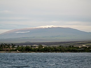
The fifteen volcanoes that make up the eight principal islands of Hawaii are the youngest in a chain of more than 129 volcanoes that stretch 5,800 kilometres (3,600 mi) across the North Pacific Ocean, called the Hawaiian–Emperor seamount chain. Hawaiʻi's volcanoes rise an average of 4,600 metres (15,000 ft) to reach sea level from their base. The largest, Mauna Loa, is 4,169 metres (13,678 ft) high. As shield volcanoes, they are built by accumulated lava flows, growing a few meters or feet at a time to form a broad and gently sloping shape.

Bransfield Strait or Fleet Sea is a body of water about 100 kilometres (60 mi) wide extending for 300 miles (500 km) in a general northeast – southwest direction between the South Shetland Islands and the Antarctic Peninsula.

An ocean bank, sometimes referred to as a fishing bank or simply bank, is a part of the seabed that is shallow compared to its surrounding area, such as a shoal or the top of an underwater hill. Somewhat like continental slopes, ocean bank slopes can upwell as tidal and other flows intercept them, sometimes resulting in nutrient-rich currents. Because of this, some large banks, such as Dogger Bank and the Grand Banks of Newfoundland, are among the richest fishing grounds in the world.

Meiji Seamount, named after Emperor Meiji, the 122nd Emperor of Japan, is the oldest seamount in the Hawaiian-Emperor seamount chain, with an estimated age of 82 million years. It lies at the northernmost end of the chain, and is perched at the outer slope of the Kuril–Kamchatka Trench. Like the rest of the Emperor seamounts, it was formed by the Hawaii hotspot volcanism, grew to become an island, and has since subsided to below sea level, all while being carried first north and now northwest by the motion of the Pacific Plate. Meiji Seamount is thus an example of a particular type of seamount known as a guyot, and some publications refer to it as Meiji Guyot.

The New England Seamounts is a chain of over twenty underwater extinct volcanic mountains known as seamounts. This chain is located off the coast of Massachusetts in the Atlantic Ocean and extends over 1,000 km from the edge of Georges Bank. Many of the peaks of these mountains rise over 4,000 m from the seabed. The New England Seamounts chain is the longest such chain in the North Atlantic and is home to a diverse range of deep sea fauna. Scientists have visited the chain on various occasions to survey the geologic makeup and biota of the region. The chain is part of the Great Meteor hotspot track and was formed by the movement of the North American Plate over the New England hotspot. The oldest volcanoes that were formed by the same hotspot are northwest of Hudson Bay, Canada. Part of the seamount chain is protected by Northeast Canyons and Seamounts Marine National Monument.

Bowie Seamount is a large submarine volcano in the northeastern Pacific Ocean, located 180 km (110 mi) west of Haida Gwaii, British Columbia, Canada.

Davidson Seamount is a seamount located off the coast of Central California, 80 mi (129 km) southwest of Monterey and 75 mi (121 km) west of San Simeon. At 26 mi (42 km) long and 8 mi (13 km) wide, it is one of the largest known seamounts in the world. From base to crest, the seamount is 7,480 ft (2,280 m) tall, yet its summit is still 4,101 ft (1,250 m) below the sea surface. The seamount is biologically diverse, with 237 species and 27 types of deep-sea coral having been identified.

Detroit Seamount, which was formed around 76 million years ago, is one of the oldest seamounts of the Hawaiian-Emperor seamount chain. It lies near the northernmost end of the chain and is south of Aleutian Islands, at 51°28.80′N167°36′E It is a seamount in the chain, located north of the hinge of the "V" in the image at right.
The following outline is provided as an overview of and introduction to Oceanography.

Orca Seamount is a seamount near King George Island in Antarctica, in the Bransfield Strait. While it is inactive, last volcanic activity at Orca Seamount is judged to have occurred in the recent past as there are temperature anomalies in the seawater around at the seamount. Thermophilic and hyperthermophilic microorganisms organism have been found at the seamount.

Koko Guyot is a 48.1-million-year-old guyot, a type of underwater volcano with a flat top, which lies near the southern end of the Emperor seamounts, about 200 km (124 mi) north of the "bend" in the volcanic Hawaiian-Emperor seamount chain. Pillow lava has been sampled on the north west flank of Koko Seamount, and the oldest dated lava is 40 million years old. Seismic studies indicate that it is built on a 9 km (6 mi) thick portion of the Pacific Plate. The oldest rock from the north side of Koko Seamount is dated at 52.6 and the south side of Koko at 50.4 million years ago. To the southeast of the bend is Kimmei Seamount at 47.9 million years ago and southeast of it, Daikakuji at 46.7.
Yomei Seamount is a seamount of the Hawaiian-Emperor seamount chain in the northern Pacific Ocean.

Yuryaku Seamount is a seamount and guyot (flat-topped) located northwest of Hawaii. It is located a little southwest of the V-shaped bend separating the Emperor Seamounts from the older Hawaiian islands, all of the Hawaiian-Emperor seamount chain in the North Pacific Ocean.
Kanmu Seamount is a seamount lying within the Hawaiian-Emperor seamount chain in the Pacific Ocean. The last eruption of Kanmu Seamount is unknown.

Wordie Seamount is a seamount located in Bransfield Strait, Antarctica. The feature is named after James Wordie, geologist on Ernest Shackleton's 1914 expedition to Antarctica.


