Related Research Articles

Desidae is a family of spiders, some of which are known as intertidal spiders. The family is named for the genus Desis, members of which live in a very unusual location — between the tides. The family has been reevaluated in recent years and now includes inland genera and species as well, such as Badumna and Phryganoporus. In 2017, the family Amphinectidae was merged into Desidae. The family Toxopidae has been separated off. Those intertidal spiders that are truly marine commonly live in barnacle shells, which they seal up with silk; this allows them to maintain an air bubble during high tide. They emerge at night to feed on various small arthropods that live in the intertidal zone.

An ocean current is a continuous, directed movement of seawater generated by a number of forces acting upon the water, including wind, the Coriolis effect, breaking waves, cabbeling, and temperature and salinity differences. Depth contours, shoreline configurations, and interactions with other currents influence a current's direction and strength. Ocean currents are primarily horizontal water movements.
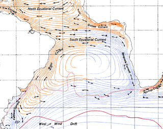
The Benguela Current is the broad, northward flowing ocean current that forms the eastern portion of the South Atlantic Ocean gyre. The current extends from roughly Cape Point in the south, to the position of the Angola-Benguela front in the north, at around 16°S. The current is driven by the prevailing south easterly trade winds. Inshore of the Benguela Current proper, the south easterly winds drive coastal upwelling, forming the Benguela Upwelling System. The cold, nutrient rich waters that upwell from around 200–300 m (656–984 ft) depth in turn fuel high rates of phytoplankton growth, and sustain the productive Benguela ecosystem.

The Kuroshio Current, also known as the Black or Japan Current or the Black Stream, is a north-flowing, warm ocean current on the west side of the North Pacific Ocean basin. It was named for the deep blue appearance of its waters. Similar to the Gulf Stream in the North Atlantic, the Kuroshio is a powerful western boundary current that transports warm equatorial water poleward and forms the western limb of the North Pacific Subtropical Gyre. Off the East Coast of Japan, it merges with the Oyashio Current to form the North Pacific Current.
High-nutrient, low-chlorophyll (HNLC) regions are regions of the ocean where the abundance of phytoplankton is low and fairly constant despite the availability of macronutrients. Phytoplankton rely on a suite of nutrients for cellular function. Macronutrients are generally available in higher quantities in surface ocean waters, and are the typical components of common garden fertilizers. Micronutrients are generally available in lower quantities and include trace metals. Macronutrients are typically available in millimolar concentrations, while micronutrients are generally available in micro- to nanomolar concentrations. In general, nitrogen tends to be a limiting ocean nutrient, but in HNLC regions it is never significantly depleted. Instead, these regions tend to be limited by low concentrations of metabolizable iron. Iron is a critical phytoplankton micronutrient necessary for enzyme catalysis and electron transport.
The East Australian Current (EAC) is a warm, southward, western boundary current that is formed from the South Equatorial Current (SEC) crossing the Coral Sea and reaching the eastern coast of Australia. At around 15° S near the Australian coast the SEC divides forming the southward flow of the EAC. It is the largest ocean current close to the shores of Australia.
The North Equatorial Current (NEC) is a westward wind-driven current mostly located near the equator, but the location varies from different oceans. The NEC in the Pacific and the Atlantic is about 5°-20°N, while the NEC in the Indian Ocean is very close to the equator. It ranges from the sea surface down to 400 m in the western Pacific.

A parent to the Florida Current, the Loop Current is a warm ocean current that flows northward between Cuba and the Yucatán Peninsula, moves north into the Gulf of Mexico, loops east and south before exiting to the east through the Florida Straits and joining the Gulf Stream. The Loop Current is an extension of the western boundary current of the North Atlantic subtropical gyre. Serving as the dominant circulation feature in the Eastern Gulf of Mexico, the Loop Currents transports between 23 and 27 sverdrups and reaches maximum flow speeds of from 1.5 to 1.8 meters/second.

The North Pacific Gyre (NPG) or North Pacific Subtropical Gyre (NPSG), located in the northern Pacific Ocean, is one of the five major oceanic gyres. This gyre covers most of the northern Pacific Ocean. It is the largest ecosystem on Earth, located between the equator and 50° N latitude, and comprising 20 million square kilometers. The gyre has a clockwise circular pattern and is formed by four prevailing ocean currents: the North Pacific Current to the north, the California Current to the east, the North Equatorial Current to the south, and the Kuroshio Current to the west. It is the site of an unusually intense collection of human-created marine debris, known as the Great Pacific Garbage Patch.
The Madagascar current is an oceanic current in the west Indian Ocean.

The Japanese eel is a species of anguillid eel found in Japan, Korea, China, and Vietnam, as well as the northern Philippines. There are three main species under the Anguilla genus, and all three share very similar characteristics. These species are so similar that it is believed that they spawned from the same species and then experienced a separation due to different environments in the ocean. Like all the eels of the genus Anguilla and the family Anguillidae, it is catadromous, meaning it spawns in the sea but lives parts of its life in freshwater. Raised in aquaculture ponds in most countries, the Japanese eel makes up 95% of the commercially sold eel in Japan, the other 5% is shipped over by air to the country from Europe. This food in Japan is called unagi; they are an essential part of the food culture, with many restaurants serving grilled eel called kabayaki. However, presumably due to a combination of overfishing and habitat loss or changing water conditions in the ocean interfering with spawning and the transport of their leptocephali this species is critically endangered.

The equator is a circle of latitude that divides a spheroid, such as Earth, into the northern and southern hemispheres. On Earth, it is an imaginary line located at 0 degrees latitude, about 40,075 km (24,901 mi) in circumference, halfway between the North and South poles. The term can also be used for any other celestial body that is roughly spherical.
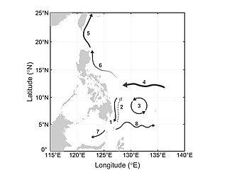
The Mindanao Current (MC) is a southward current in the western Pacific Ocean that transports mass and freshwater between ocean basins. It is a low-latitude western boundary current that follows the eastern coast of the Philippine island group and its namesake, Mindanao. The MC forms from the North Equatorial Current (NEC) that flows from east to west between 10-20°N. As it travels west, the NEC reaches its western limit: the coast of the Philippines. Once it encounters shallower waters near land, it “splits” into two branches: one moves northward and becomes the Kuroshio current and one moves southward and becomes the Mindanao Current. The process of splitting is called a bifurcation.
Tropical instability waves, often abbreviated TIW, are a phenomenon in which the interface between areas of warm and cold sea surface temperatures near the equator form a regular pattern of westward-propagating waves. These waves are often present in the Atlantic Ocean, extending westward from the African coast, but are more easily recognizable in the Pacific, extending westward from South America. They have an average period of about 30 days and wavelength of about 1100 kilometers, and are largest in amplitude between June and November. They are also largest during La Niña conditions, and may disappear when strong El Niño conditions are present.
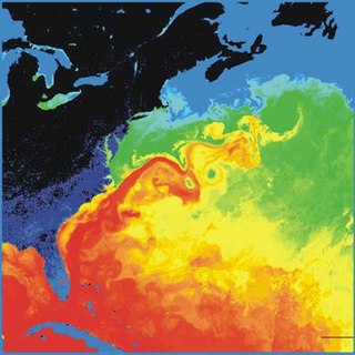
Cold core rings are a type of oceanic eddy, which are characterized as unstable, time-dependent swirling, independent ‘cells’ that separate from their respective ocean current and move into water bodies with different physical, chemical, and biological characteristics, often bringing the physical, chemical, and biological characteristics of the waters of their origin into the water bodies into which they travel. Their size can range from 1 millimeter (0.039 in) to over 10,000 kilometers (6,200 mi) in diameter with depths over 5 kilometers (3.1 mi). Cold core rings are the product of warm water currents wrapping around a colder water mass as it deviates away from its respective current. The direction an eddy swirls can be categorized as either cyclonic or anticyclonic, which is, in the Northern Hemisphere, counterclockwise and clockwise respectively, and in the Southern Hemisphere, clockwise and counterclockwise respectively as a result of the Coriolis effect. Although eddies have large amounts of kinetic energy, their rotation is relatively quick to decrease in relation to the amount of viscous friction in water. They typically last for a few weeks to a year. The nature of eddies are such that the center of the eddy, the outer swirling ring, and the surrounding waters are well stratified and maintain all of their distinctive physical, chemical, and biological properties throughout the eddy’s lifetime, before losing their distinctive characteristics at the end of the life of the cold core ring.

Haida Eddies are episodic, clockwise rotating ocean eddies that form during the winter off the west coast of British Columbia’s Haida Gwaii and Alaska’s Alexander Archipelago. These eddies are notable for their large size, persistence, and frequent recurrence. Rivers flowing off the North American continent supply the continental shelf in the Hecate Strait with warmer, fresher, and nutrient-enriched water. Haida eddies are formed every winter when this rapid outflow of water through the strait wraps around Cape St. James at the southern tip of Haida Gwaii, and meets with the cooler waters of the Alaska Current. This forms a series of plumes which can merge into large eddies that are shed into the northeast Pacific Ocean by late winter, and may persist for up to two years.
The Brazil–Falkland Confluence Zone is a very energetic region of water just off the coast of Argentina and Uruguay where the warm poleward flowing Brazil Current and the cold equatorward flowing Falkland Current converge. The region oscillates latitudinally, but in general the region of confluence occurs between 35 and 45 degrees south latitude and 50 to 70 degrees west longitude. The confluence of these two currents causes a strong thermohaline to exist and causes numerous high energy eddies to form.

The Kuroshio Current is a northward flowing Western Boundary Current (WBC) in the Pacific Ocean. It is a bifurcation arm of the North Equatorial Current and consists of northwestern Pacific Ocean water. The other arm is the southward flowing Mindanao Current. The Kuroshio Current flows along the eastern Philippine coast, up to 13.7 Sv... of it leaking into the Luzon Strait - the gap between the Philippines and Taiwan - before continuing along the Japanese coast. Some of the leaked water manages to intrude into the South China Sea (SCS). This affects the heat and salt budgets and circulation and eddy generation mechanisms in the SCS. There are various theories about possible intrusion paths and what mechanisms initiate them.
Low-latitude western boundary currents (LLWBC) are western boundary currents located between the subtropical gyres, within 20° of the equator. They are important for closing the tropical circulation driven by the equatorial zonal flow, and facilitate inter-ocean transport between the subtropical gyres. They occur in regions of negative (positive) wind stress curl in the southern (northern) hemisphere, and originate at the western bifurcation point of the South or North Equatorial Current. They are typically equatorward (cyclonic) as opposed to sub-tropical western boundary currents, which tend to be poleward (anticyclonic). Some well-known examples include the Mindanao Current (MC) and the East African Coastal Current (EACC).

The North Brazil Current (NBC) retroflects north-eastwards and merges into the North Equatorial Counter Current (NECC). The retroflection occurs in a seasonal pattern when there is strong retroflection from late summer to early winter. There is weakened or no retroflection during other times of the year. Just like in the Agulhas Current, the retroflection also sheds some eddies that make their way to the Caribbean Sea through the Lesser Antilles.
References
- ↑ Aruda, W.Z. Eddies Along Western Boundaries. http://www.im.ufrj.br/~wilton/Papers/Wilton_PhDdiss.pdf
- ↑ Primavera, K.H., Jacinto, G.S., San Diego-McGlon, M.L., Villanoy, C.L. Water Stability. Nutrient Flux, and Chlorophyll-a Distribution in the Mindanao Eddy. Natural Science. 8: 163-173.