Douglas Island

Last updated
Douglas Harbor in Douglas, Alaska. Mayflower Island, in the midground at right, houses a U.S. Coast Guard station. Mount Juneau is in the background. Douglas 6 March 2011 006.jpg
Douglas Harbor in Douglas, Alaska. Mayflower Island, in the midground at right, houses a U.S. Coast Guard station. Mount Juneau is in the background.

Douglas Island is a tidal island in the U.S. state of Alaska. It is part of the city and borough of Juneau, just west of downtown Juneau and east of Admiralty Island. It is separated from mainland Juneau by the Gastineau Channel, and contains the communities of Douglas and West Juneau.

Contents

History

Douglas Island was named for John Douglas, Bishop of Salisbury, by Captain George Vancouver. Joseph Whidbey, master of HMS Discovery during Vancouver's expedition, was the first to sight it in 1794. [1] In 1886, people began to travel to Douglas Island to settle near the developing Treadwell gold mine. By 1902, the Douglas Island community had grown to a population of over 2800 residents, as businesses, schools, and homes began to develop alongside the expansion of the nearby gold mine. After the Gastineau Channel flooded the Treadwell mining tunnels in 1917, many residents were forced to move after the town's dramatic economic downturn, causing the Douglas population to decrease steadily until the late 1930s. [2]

During the summer of 1962, the Douglas Indian Village was seized and burned down by Douglas city officials and residents in order to forgo the development of the Douglas Harbor project. The Douglas Harbor project, which was initiated by the Douglas tribe and the Bureau of Indian Affairs, was a plan to construct a harbor on the Douglas Indian Village site with the intention of having the village rebuilt. In order to obtain control of the project, Douglas city officials invoked eminent domain on the village site while tribal members were fishing at their camps along the Taku River. The tribal members were not compensated for the property and belongings that were lost in the burning of their village and were forced to relocate once they returned to the island. [3]

Photo of Douglas Island by Frank La Roche ca. 1897 Douglas Island, Alaska, ca 1897 (LAROCHE 19).jpeg
Photo of Douglas Island by Frank La Roche ca. 1897

The Juneau-Douglas Bridge, which was first built in 1935, connected Douglas Island with West Juneau. In 1970, the communities of Douglas and Juneau joined together to form the City and Borough of Juneau. [2] The Juneau-Douglas Bridge was later rebuilt in 1980 to provide a two lane road to and from the island and to accommodate both vehicular and pedestrian traffic. [4] There have been plans to build a new bridge from North Douglas to the Mendenhall Valley.

Geography

Admiralty Island lies to the west and south, across the Stephens Passage.

Resting place of several members of the Taku's Raven Clan. Douglas 6 March 2011 001.jpg
Resting place of several members of the Taku's Raven Clan.
Mining operations at Treadwell Gold Mine on Douglas Island, circa 1900 Mining operations at Treadwell Gold Mining Co, Douglas Island, Alaska, ca 1900 (HESTER 280).jpeg
Mining operations at Treadwell Gold Mine on Douglas Island, circa 1900

Features of the island include remnants of the Treadwell gold mine, Sandy Beach, the only sand beach in the Juneau area (made from mine tailings), Eaglecrest Ski Area, Perseverance Theatre, and the Douglas Public Library. As a tidal island, Douglas is connected to the mainland at its north end when the Gastineau Channel is at low tide. During low tide, Douglas Island is connected with Juneau's Twin Lakes area, the Juneau International Airport as well as other sites.

Douglas Bridge, the bridge crossing Gastineau Channel, connecting downtown Juneau with Douglas Island. The original bridge was built in 1935. The replacement (current) bridge, shown here, was completed in 1980. Douglas Bridge.jpg
Douglas Bridge, the bridge crossing Gastineau Channel, connecting downtown Juneau with Douglas Island. The original bridge was built in 1935. The replacement (current) bridge, shown here, was completed in 1980.

Douglas is usually thought of as two areas: downtown Douglas 58°16′32″N134°23′33″W / 58.27556°N 134.39250°W / 58.27556; -134.39250 (including West Juneau 58°17′42″N134°25′46″W / 58.29500°N 134.42944°W / 58.29500; -134.42944 ), containing Douglas Harbor, Sandy Beach, the mines, the library, Gastineau Elementary, the theatre, the gas station, the few bars and restaurants, and the bridge to Juneau; and North Douglas Island, containing a tank farm, Eaglecrest Ski Area and a heliport.

The island has a land area of 76.93 square miles (199.25 km2) and had a population of 5,297 at the 2000 United States Census, with over half of the island's population residing in Douglas proper. It is part of the City and Borough of Juneau. The island's highest point, Mount Ben Stewart, was named in honor of Benjamin D. Stewart (1878–1976), an early mayor of Juneau.

Climate

Climate data for Douglas Island, Alaska (Eaglecrest, 19912020 normals, extremes 2004present)
MonthJanFebMarAprMayJunJulAugSepOctNovDecYear
Record high °F (°C)53
(12)
53
(12)
54
(12)
61
(16)
75
(24)
85
(29)
82
(28)
84
(29)
75
(24)
60
(16)
50
(10)
49
(9)
85
(29)
Mean maximum °F (°C)39.1
(3.9)
41.4
(5.2)
44.4
(6.9)
53.9
(12.2)
67.4
(19.7)
73.4
(23.0)
75.1
(23.9)
74.8
(23.8)
65.5
(18.6)
51.8
(11.0)
42.3
(5.7)
40.3
(4.6)
78.5
(25.8)
Average high °F (°C)28.9
(−1.7)
30.2
(−1.0)
33.7
(0.9)
43.6
(6.4)
52.3
(11.3)
57.7
(14.3)
59.5
(15.3)
59.3
(15.2)
52.9
(11.6)
42.3
(5.7)
34.1
(1.2)
29.7
(−1.3)
43.7
(6.5)
Daily mean °F (°C)24.4
(−4.2)
25.6
(−3.6)
28.2
(−2.1)
36.3
(2.4)
43.9
(6.6)
50.2
(10.1)
53.4
(11.9)
52.9
(11.6)
47.1
(8.4)
38.0
(3.3)
30.2
(−1.0)
26.3
(−3.2)
38.0
(3.3)
Average low °F (°C)19.9
(−6.7)
20.9
(−6.2)
22.6
(−5.2)
28.9
(−1.7)
35.4
(1.9)
42.6
(5.9)
47.3
(8.5)
46.5
(8.1)
41.2
(5.1)
33.7
(0.9)
26.2
(−3.2)
22.8
(−5.1)
32.3
(0.2)
Mean minimum °F (°C)1.4
(−17.0)
4.6
(−15.2)
6.6
(−14.1)
18.5
(−7.5)
27.0
(−2.8)
32.4
(0.2)
39.2
(4.0)
39.1
(3.9)
30.6
(−0.8)
25.2
(−3.8)
10.6
(−11.9)
7.3
(−13.7)
−4.2
(−20.1)
Record low °F (°C)−10
(−23)
−13
(−25)
−5
(−21)
10
(−12)
7
(−14)
16
(−9)
25
(−4)
33
(1)
18
(−8)
14
(−10)
−5
(−21)
−7
(−22)
−13
(−25)
Average precipitation inches (mm)9.44
(240)
6.52
(166)
6.29
(160)
5.94
(151)
5.32
(135)
6.07
(154)
8.11
(206)
10.07
(256)
13.09
(332)
12.65
(321)
10.59
(269)
10.43
(265)
104.52
(2,655)
Average snowfall inches (cm)36.2
(92)
39.3
(100)
37.2
(94)
9.2
(23)
0.7
(1.8)
0.0
(0.0)
0.0
(0.0)
0.0
(0.0)
0.0
(0.0)
1.8
(4.6)
28.8
(73)
40.6
(103)
193.8
(491.4)
Average precipitation days (≥ 0.01 in)22.217.918.117.515.919.419.620.521.122.922.022.3239.4
Average snowy days (≥ 0.1 in)15.113.714.76.10.30.00.00.00.00.712.517.180.2
Source: NOAA [5] [6]

Politics

Following the 2012 election of Merrill Sanford, the incumbent mayor of Juneau, the Juneau Empire noted the island's "outsized contribution" to Juneau-area politics. Sanford, Byron Mallott (former lieutenant governor of Alaska) and Dennis Egan (currently Juneau's representative in the Alaska Senate) live in West Juneau. Sally Smith, who succeeded Egan as mayor, lives in the Lawson Creek neighborhood between Douglas and West Juneau, while her successor Bruce Botelho lives in Douglas. Beth Kerttula, who represented portions of Juneau in the Alaska House of Representatives from 1999 to 2014, lives in North Douglas. [7] Additionally, John Dimond, the first Juneau-based justice of the Alaska Supreme Court, lived in Douglas, while his successor Robert Boochever lived along the Douglas Highway a half-mile north of Douglas's then-city limits.

Related Research Articles

<span class="mw-page-title-main">Juneau, Alaska</span> Capital city of Alaska, United States

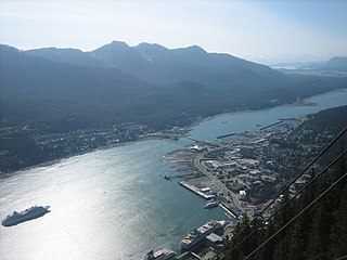
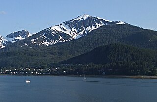
The City and Borough of Juneau, more commonly known simply as Juneau, is the capital city of the state of Alaska. Located in the Gastineau Channel and the Alaskan panhandle, it is a unified municipality and the second-largest city in the United States by area. Juneau was named the capital of Alaska in 1906, when the government of what was then the District of Alaska was moved from Sitka as dictated by the U.S. Congress in 1900. The municipality unified on July 1, 1970, when the city of Juneau merged with the city of Douglas and the surrounding Greater Juneau Borough to form the current municipality, which is larger by area than both Rhode Island and Delaware.

<span class="mw-page-title-main">Douglas, Juneau, Alaska</span> Place in Alaska, United States

Douglas is a community on Douglas Island in southeastern Alaska, directly across the Gastineau Channel from downtown Juneau.

<span class="mw-page-title-main">Gastineau Channel</span> Channel between the mainland of the U.S. state of Alaska and Douglas Island

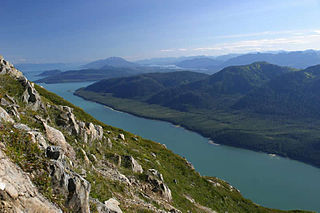
Gastineau Channel is a channel between the mainland of the U.S. state of Alaska and Douglas Island in the Alexander Archipelago of southeastern Alaska. It separates Juneau on the mainland side from Douglas, on Douglas Island. The first European to sight the channel was Joseph Whidbey whilst serving on the Royal Navy's Vancouver Expedition early in August 1794, first from the south and later from the west. It was probably named for John Gastineau, an English civil engineer and surveyor.

<span class="mw-page-title-main">Auke Bay, Juneau</span> Neighborhood in City and Borough of Juneau, Alaska, United States

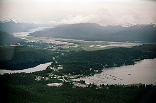
Auke Bay is a neighborhood located in the city and borough of Juneau, Alaska, that contains Auke Bay Harbor, Auke Lake, the University of Alaska Southeast, an elementary school, a church, a post office, a bar, a coffee shop, a waffle house, a thrift shop, a Thai restaurant, and one convenience store. The view of the Mendenhall Glacier behind Auke Bay and Mount McGinnis towering over Auke Lake are some of the most popular photo opportunities in Juneau. The ferry terminal of the Alaska Marine Highway system is also located further out the road in Auke Bay at about 14 miles. The flamingo house on Auke Lake is a local attraction, known for its topical or weather-related formations of pink lawn flamingos. Whale watchings targeting curious humpbacks are available. Humpbacks in these areas are known to demonstrate special feeding methods, so-called "bubble-net feeding", and come very close to shores.

<span class="mw-page-title-main">Treadwell gold mine</span>

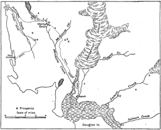
The Treadwell gold mine was on the south side of Douglas Island, .5-mile (0.80 km) east of downtown Douglas and southeast of downtown Juneau, owned and operated by John Treadwell. Composed of four sub-sites, Treadwell was in its time the largest hard rock gold mine in the world, employing over 2,000 people. Between 1881 and 1922, over 3 million troy ounces of gold were extracted. Not much remains today except for a few crumbling buildings and a "glory hole". Although John Treadwell had twelve years of experience in both placer and lode mines, he was a carpenter and builder by trade who had come to Alaska prior to the Klondike Gold Rush.

The Juneau mining district is a gold mining area in the U.S. state of Alaska.

<span class="mw-page-title-main">Douglas Harbor</span>

Douglas Harbor is a harbor off the coast of Douglas Island in Juneau, Alaska.

<span class="mw-page-title-main">West Juneau, Alaska</span>

West Juneau is a populated place in Juneau, Alaska, United States. It is located on Douglas Island 1.8 miles (2.9 km) northwest of Douglas. Despite its location on Douglas Island, the neighborhood was juridically a part of the City of Juneau, rather than the City of Douglas, prior to municipal unification in 1970.

<span class="mw-page-title-main">Tee Harbor, Juneau</span>

Tee Harbor refers to two adjacent populated places in the City and Borough of Juneau, Alaska. The area had a population of 32 in 1950. It is located 3 miles (4.8 km) northwest of Fairhaven and 17 miles (27 km) northwest of the main city of Juneau.

<span class="mw-page-title-main">Kowee Creek</span> River in Juneau, Alaska, United States

Kowee Creek is a river on Douglas Island in the City and Borough of Juneau, Alaska, United States. Its origin is southeast of Mount Troy and it flows north-northeast to Gastineau Channel near West Juneau; it is 0.5 miles (0.80 km) southwest of the city of Juneau. Kowee Creek is nearly 10 miles (16 km) long. It has a drainage basin of about 50 square miles (130 km2) and two transverse tributaries.

Ninemile Creek is a river on Douglas Island in the City and Borough of Juneau, Alaska, United States. Its origin is in hills to the southeast and it flows northwest to Gastineau Channel near West Juneau. It is 1.2 miles (1.9 km) east of Entrance Point and 6.4 miles (10.3 km) northwest of the city of Juneau.

Elevenmile Creek is a river on Douglas Island in the City and Borough of Juneau (CBJ), Alaska, United States. Its origin is in hills to the southeast and it flows northwest to Fritz Cove, a part of Stephens Passage; it is 1.6 miles (2.6 km) southwest of Entrance Point and 8.6 miles (13.8 km) west of the city of Juneau.

<span class="mw-page-title-main">Juneau–Douglas Bridge</span> Bridge in Alaska, USA

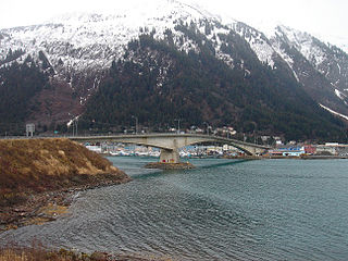
The Douglas Bridge is located in Juneau, Alaska. Spanning the Gastineau Channel, it connects Juneau's eastern, mainland side with the city's communities on Douglas Island to the west. The current span is the second bridge of the same name; the original, built in 1935, was demolished in 1981 following the completion of its replacement in 1980.

The Alaska-Gastineau Mining Co. had its offices in 25 Broad St., New York City, New York. It was the operating company for the Alaska Gold Mines Co. in Alaska. It worked the Alaska-Gastineau Mine/Perseverance Mine in the Silver Bow Basin, approximately 4 miles (6.4 km) from Juneau and processed its ore at an old remodeled mill and crushing plant at Sheep Creek. The property of the Alaska Juneau Gold Mining Co. adjoined the Alaska Gastineau on the west.

<span class="mw-page-title-main">Alaska-Juneau Gold Mining Company</span>

The Alaska-Juneau Gold Mining Company (AJGMC) was incorporated under the laws of West Virginia, USA in 1897. Its lode mining claims covered approximately 402.37 acres (162.83 ha) on the wide vein called the Juneau gold belt of which it owned one mile on the outcrop.

<span class="mw-page-title-main">Lemon Creek (Alaska)</span>

Lemon Creek is a stream in the U.S. state of Alaska. It is primarily filled by the meltwater of Lemon Creek Glacier, as well as another glacier. The Lemon name is said to come from traveling miner John Lemon, who reportedly had a placer mine on the creek in 1879.

John Treadwell (1842–1927) was a Canadian gold miner. He was born in St. Andrews, New Brunswick, Canada. He owned and operated the Treadwell gold mine through the Treadwell Mining Company. He was responsible for initiating low-grade gold mining in Alaska adopting most advanced operations on a big scale, which boosted the economy of the wilderness areas. His four mines formed the largest complex in the world at that time. Treadwell's mine complex "put Juneau on the map".

<span class="mw-page-title-main">Juneau gold belt</span> Juneau gold belt buried deep underground mystery

The Juneau gold belt is located in the southeastern portion of the U.S. state of Alaska. This belt is approximately 100 miles (160 km) in length, north/northwest-trending, and extends from Berners Bay southeastward to Windham Bay, 60 miles (97 km) southeast of Juneau, and includes Douglas Island. The belt contains over 200 gold-quartz-vein deposits with production nearing 7,000,000 ounces (200,000,000 g) of gold. More than three-quarters of Alaska's lode gold was mined from the Juneau gold belt.

<span class="mw-page-title-main">Capital City Fire/Rescue</span>

Capital City Fire/Rescue (CCFR) provides fire suppression and emergency medical services to the city of Juneau, Alaska, United States.

<span class="mw-page-title-main">Mount Bradley (Mount Jumbo)</span> Mountain in Alaska, United States

Mount Bradley is a 3,337-foot (1,017 m) elevation mountain summit located on Douglas Island in the Alexander Archipelago, in the U.S. state of Alaska. It is the third-highest peak on the island, and is situated 4 mi (6 km) south of Juneau, on land managed by Tongass National Forest. Although modest in elevation, relief is significant since the peak rises up from tidewater of Gastineau Channel in approximately two miles. Its nearest higher neighbor is Mount Ben Stewart, 5.6 mi (9 km) to the northwest.

References

  1. "Historic Preservation in Juneau". juneau.org. Archived from the original on 7 November 2018. Retrieved 28 April 2018.
  2. 1 2 H., Choate, Glenda. Gillette, Gary (1989). Douglas townsite historic building survey. City and Borough of Juneau. OCLC   20864179.
  3. Lindoff, Kamal (2019-08-27). "Douglas Indian Village Fire of 1962". Douglas Indian Association - DIATaku. Retrieved 2021-11-30.
  4. "Structures / Douglas Bridge / Images". Structurae. Retrieved 2011-02-18.
  5. "Eaglecrest, AK - NOWData Juneau" . Retrieved August 11, 2022.
  6. "U.S. Climate Normals Quick Access – Station: Eaglecrest Base, AK". National Oceanic and Atmospheric Administration. Retrieved February 15, 2023.
  7. Miller, Mark D. (November 15, 2012). "In Juneau politics, Douglas Island looms large". Juneau Empire. Retrieved January 20, 2015.

Coordinates: 58°16′14″N134°30′21″W / 58.27056°N 134.50583°W / 58.27056; -134.50583