
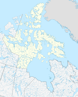
Victoria Island is a large island in the Arctic Archipelago that straddles the boundary between Nunavut and the Northwest Territories of Canada. It is the eighth largest island in the world, and at 217,291 km2 (83,897 sq mi) in area, it is Canada's second largest island. It is nearly double the size of Newfoundland (111,390 km2 [43,008 sq mi]), and is slightly larger than the island of Great Britain (209,331 km2 [80,823 sq mi]) but smaller than Honshu (225,800 km2 [87,182 sq mi]). It contains the world's largest island within an island within an island. The western third of the island lies in the Inuvik Region of the Northwest Territories; the remainder is part of Nunavut's Kitikmeot Region.

The Mid-Atlantic Ridge is a mid-ocean ridge located along the floor of the Atlantic Ocean, and part of the longest mountain range in the world. In the North Atlantic, the ridge separates the North American from the Eurasian Plate and the African Plate, north and south of the Azores Triple Junction respectively. In the South Atlantic, it separates the African and South American plates. The ridge extends from a junction with the Gakkel Ridge northeast of Greenland southward to the Bouvet Triple Junction in the South Atlantic. Although the Mid-Atlantic Ridge is mostly an underwater feature, portions of it have enough elevation to extend above sea level, for example in Iceland. The ridge has an average spreading rate of about 2.5 centimetres (1 in) per year.
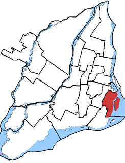
Jeanne-Le Ber was a federal electoral district in Quebec, Canada, that was represented in the House of Commons of Canada from 2004 to 2015. Its population in 2006 was 112,863. It was abolished for the 2015 election and dissolved into Ville-Marie—Le Sud-Ouest—Île-des-Sœurs and LaSalle—Émard—Verdun.

Tawatinaw is a hamlet in Alberta, Canada within Westlock County. It is located on Township Road 614, 2 kilometres (1.2 mi) east of Highway 2 and approximately 70 kilometres (43 mi) north of the City of Edmonton.
There are several lakes named Mud Lake within the Canadian province of Alberta.

Strathclair is a locality in the province of Manitoba in Western Canada. It is located northwest of Brandon, Manitoba and is on Highway 16. It lies within the Rural Municipality of Yellowhead. The population is 709 in the 2016 census.
Lady Franklin Point is a landform in the Canadian Arctic territory of Nunavut. It is located on southwestern Victoria Island in the Coronation Gulf by Austin Bay at the eastern entrance of Dolphin and Union Strait.
Principe Channel is a strait on the North Coast of British Columbia, Canada, located between Banks Island (W) and Pitt Island (E). "Principe" means "prince" in Spanish.
Saqajaa {Inuktitut syllabics: ᓴᖃᔮ) formerly Sakkiak Island is one of the uninhabited Canadian arctic islands located in Hudson Strait, Nunavut, Canada. It is a Baffin Island offshore island in the Qikiqtaaluk Region, separated by deep water from Cape Dorset 64°10′40″N76°29′00″W, 1.5 mi (2.4 km) to the south-southwest. The island is approximately 6 km2 (2.3 sq mi) in size, 2.25 mi (3.62 km) long, and 1 mi (1.6 km) wide. The elevation is approximately 65 m (213 ft) above sea level.
The Kitsault River is a river on the North Coast of British Columbia, Canada, located at the head of Alice Arm, which is the east arm of Observatory Inlet, which is itself an arm of Portland Inlet. Located at the mouth of the river are the localities of Alice Arm, Kitsault and Gits'oohl, a community of the Nisga'a people which was the Gitzault Indian Reserve No. 24 prior to the Nisga'a Treaty.
Yale First Nation is a First Nations government located at Yale, British Columbia. Yale has 16 distinct reserves stretching from near Sawmill Creek to American Creek, with the most southern reserve situated at Ruby Creek in the District of Kent.
The Tlowitsis Nation, formerly the Klowitsis Tribe, the Turnour Island Band and the Tlowitsis-Mumtagila First Nation, is the Indian Act band government of the Ławit'sis (Tlowitsis) tribe of the Kwakwaka'wakw peoples, located in the Queen Charlotte Strait-Johnstone Strait area in the Discovery Islands between Vancouver Island and the British Columbia mainland in Canada. Ławit'sis territory covers parts of northern Vancouver Island, Johnstone Strait, and adjoining inlets of the mainland. Kalugwis, on Turnour Island, was their principal community in times past, but the band's offices are in the city of Campbell River to the southeast. Hanatsa IR No. 6 on Port Neville is the most populated of the band's Indian reserves.
The Tseycum First Nation is a First Nations government located on Vancouver Island. In the 1850s they were signatories to the Douglas Treaties.
Kitselas First Nation is the band government of the Kitselas subgroup of the Tsimshian. The band government is based at Gitaus in the Skeena Valley in the Skeena River valley to the northeast of the city of Terrace, British Columbia, Canada. Though there is no Tsimshian tribal council, they are a participant in the Tsimshian First Nations treaty council.

Bonnington Falls were waterfalls submerged by dams on the Kootenay River between the cities of Castlegar and Nelson, in the West Kootenay region of southern British Columbia. The upper falls was named after the Falls of Clyde upper falls of Bonnington Linn.

The borders of the oceans are the limits of Earth's oceanic waters. The definition and number of oceans can vary depending on the adopted criteria. The principal divisions of the five oceans are the: Pacific Ocean, Atlantic Ocean, Indian Ocean, Southern (Antarctic) Ocean, and Arctic Ocean. Smaller regions of the oceans are called seas, gulfs, bays, straits, and other terms. Geologically, an ocean is an area of oceanic crust covered by water.
Sir Graham Moore Islands may refer to:
Bonnington Falls is a community on the north side of the Kootenay River between the cities of Castlegar and Nelson, in the West Kootenay region of southern British Columbia. It was named after the adjacent Bonnington Falls, now submerged by hydro dams.

Caño (El) Paujil can refer to these waterfalls in Colombia:
- Caño Paujil, Caquetá, 0.56795°S 72.44063°W
- Caño El Paujil, Cesar, 9.46667°N 73.75°W
- Caño Paujil, Cesar, 9.56941°N 73.49797°W
- Caño Paujil, Meta, lat 3,76, long -73,83, 3.75749°N 73.8316°W
- Caño Paujil, Meta, lat 4,01, long -72,36, 4.01194°N 72.36444°W
- Caño Paujil, Meta, lat 4,03, long -73,75, 4.03064°N 73.74777°W
- Caño Paujil, Vichada, 5.43086°N 68.14422°W