Related Research Articles
Benthos, also known as benthon, from Greek benthos 'depth of the sea', is the community of organisms that live on, in, or near the seabed, river, lake, or stream bottom, also known as the benthic zone. This community lives in or near marine or freshwater sedimentary environments, from tidal pools along the foreshore, out to the continental shelf, and then down to the abyssal depths.

The littoral zone or nearshore is the part of a sea, lake, or river that is close to the shore. In coastal environments, the littoral zone extends from the high water mark, which is rarely inundated, to shoreline areas that are permanently submerged. The littoral zone always includes this intertidal zone, and the terms are often used interchangeably. However, the meaning of littoral zone can extend well beyond the intertidal zone.

The benthic zone is the ecological region at the lowest level of a body of water such as an ocean, lake, or stream, including the sediment surface and some sub-surface layers. Organisms living in this zone are called benthos and include microorganisms as well as larger invertebrates, such as crustaceans and polychaetes. Organisms here generally live in close relationship with the substrate and many are permanently attached to the bottom. The benthic boundary layer, which includes the bottom layer of water and the uppermost layer of sediment directly influenced by the overlying water, is an integral part of the benthic zone, as it greatly influences the biological activity that takes place there. Examples of contact soil layers include sand bottoms, rocky outcrops, coral, and bay mud.

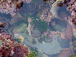
Tide pools or rock pools are shallow pools of seawater that form on the rocky intertidal shore. Many of these pools exist as separate bodies of water only at low tide.
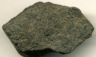
Phosphorite,phosphate rock or rock phosphate is a non-detrital sedimentary rock that contains high amounts of phosphate minerals. The phosphate content of phosphorite (or grade of phosphate rock) varies greatly, from 4% to 20% phosphorus pentoxide (P2O5). Marketed phosphate rock is enriched ("beneficiated") to at least 28%, often more than 30% P2O5. This occurs through washing, screening, de-liming, magnetic separation or flotation. By comparison, the average phosphorus content of sedimentary rocks is less than 0.2%. The phosphate is present as fluorapatite Ca5(PO4)3F typically in cryptocrystalline masses (grain sizes < 1 μm) referred to as collophane-sedimentary apatite deposits of uncertain origin. It is also present as hydroxyapatite Ca5(PO4)3OH or Ca10(PO4)6(OH)2, which is often dissolved from vertebrate bones and teeth, whereas fluorapatite can originate from hydrothermal veins. Other sources also include chemically dissolved phosphate minerals from igneous and metamorphic rocks. Phosphorite deposits often occur in extensive layers, which cumulatively cover tens of thousands of square kilometres of the Earth's crust.

The neritic zone is the relatively shallow part of the ocean above the drop-off of the continental shelf, approximately 200 meters (660 ft) in depth. From the point of view of marine biology it forms a relatively stable and well-illuminated environment for marine life, from plankton up to large fish and corals, while physical oceanography sees it as where the oceanic system interacts with the coast.

The intertidal zone, also known as the foreshore or seashore, is the area above water level at low tide and underwater at high tide. This area can include several types of habitats with various species of life, such as seastars, sea urchins, and many species of coral. Sometimes it is referred to as the littoral zone, although that can be defined as a wider region.

A rocky shore is an intertidal area of seacoasts where solid rock predominates. Rocky shores are biologically rich environments, and are a useful "natural laboratory" for studying intertidal ecology and other biological processes. Due to their high accessibility, they have been well studied for a long time and their species are well known.

Marine ecosystems are the largest of Earth's aquatic ecosystems and exist in waters that have a high salt content. These systems contrast with freshwater ecosystems, which have a lower salt content. Marine waters cover more than 70% of the surface of the Earth and account for more than 97% of Earth's water supply and 90% of habitable space on Earth. Seawater has an average salinity of 35 parts per thousand of water. Actual salinity varies among different marine ecosystems. Marine ecosystems can be divided into many zones depending upon water depth and shoreline features. The oceanic zone is the vast open part of the ocean where animals such as whales, sharks, and tuna live. The benthic zone consists of substrates below water where many invertebrates live. The intertidal zone is the area between high and low tides. Other near-shore (neritic) zones can include mudflats, seagrass meadows, mangroves, rocky intertidal systems, salt marshes, coral reefs, lagoons. In the deep water, hydrothermal vents may occur where chemosynthetic sulfur bacteria form the base of the food web.
As ocean surface waves approach shore, they get taller and break, forming the foamy, bubbly surface called surf. The region of breaking waves defines the surf zone, or breaker zone. After breaking in the surf zone, the waves continue to move in, and they run up onto the sloping front of the beach, forming an uprush of water called swash. The water then runs back again as backwash. The nearshore zone where wave water comes onto the beach is the surf zone. The water in the surf zone is shallow, usually between 5 and 10 m deep; this causes the waves to be unstable.

The Chthamalidae are a family of chthamaloid barnacles, living entirely in intertidal/subtidal habitats, characterized by a primary shell wall of eight, six, or four plates, lacking imbricating plate whorls, and either membraneous or more rarely calcareous basis. They are not found below immediate subtidal habitats, and more likely are found in the highest tier of shallow-water barnacle fauna. They can be found in the most rigorous wave-washed locations, and some species are found in the surf zone above high tide mark, only receiving water from wave action at high tide.

The Ballantine scale is a biologically defined scale for measuring the degree of exposure level of wave action on a rocky shore. Devised in 1961 by W. J. Ballantine, then at the zoology department of Queen Mary College, London, the scale is based on the observation that where shoreline species are concerned "Different species growing on rocky shores require different degrees of protection from certain aspects of the physical environment, of which wave action is often the most important." The species present in the littoral zone therefore indicate the degree of the shore's exposure.
The wrack zone or wrack line is a coastal feature where organic material and other debris is deposited at high tide. This zone acts as a natural input of marine resources into a terrestrial system, providing food and habitat for a variety of coastal organisms.
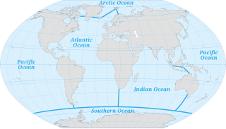
The ocean is the body of salt water which covers approximately 71% of the surface of the Earth and contains 97% of Earth's water. Another definition is "any of the large bodies of water into which the great ocean is divided". Separate names are used to identify five different areas of the ocean: Pacific Atlantic, Indian, Southern (Antarctic), and Arctic. Seawater covers approximately 361,000,000 km2 (139,000,000 sq mi) of the planet. The ocean is the principal component of Earth's hydrosphere, and therefore integral to life on Earth. Acting as a huge heat reservoir, the ocean influences climate and weather patterns. the carbon cycle and the water cycle.
Splash zone applies either to the Supralittoral zone or, in the context of Offshore construction, to the transition from air to water when lowering heavy burdens into the sea. The overall efforts applied on the crane change dramatically when the load starts touching water, up to the point where it is completely submerged. Its buoyancy reduces the static mass that the crane has to support, but contact with the waves creates widely fluctuating dynamic forces.

Harpago chiragra, common name the Chiragra spider conch, is a species of very large sea snail, a marine gastropod mollusk in the family Strombidae, the true conchs.

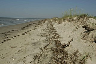
At a flat coast or flat shoreline, the land descends gradually into the sea. Flat coasts can be formed either as a result of the sea advancing into gently-sloping terrain or through the abrasion of loose rock. They may be basically divided into two parallel strips: the shoreface and the beach.

Tigriopus brevicornis is a coastal marine copepod. They are a dominant member of shallow supra tidal rock pools along the North Western European coastline. A broad range of studies have been carried out on this species, including: its ecology, physiology, phylogeography, metapopulation genetics, development and reproductive behaviour. T. brevicornis has also recently been used in ecotoxicology studies and has been trialled as a live feed for larvae in several aquaculture-based studies for the past 30 years.

Dalnevostochny Morskoy Nature Reserve is Russian's first marine reserve, covering large portions of the sea and 30 islands in Peter the Great Gulf, on the west side of the Sea of Japan. It has the highest class of environmental protection as a federal 'zapovednik'. There are four distinct areas with different biological and protection regimes, covering 63,000 ha (240 sq mi) of sea area, additional land on included islands, a 500-meter conservation strip of coastline along the marine area, and a conservation buffer zone inland to a width of 3 miles. The reserve is situated on the continental coast south of Vladivostok in the Russian Far East. The administrative district is Khasansky District of Primorsky Krai. It was formally established in 1978. The reserve is part of the UNESCO "Far East Reserve" MAB Biosphere Reserve, noted for its protection of marine biodiversity, and as a re-population area for open seas fisheries.
References
- Thurman H.V. and Trujillo A.P. 1993.Essentials of Oceanography.Upper Saddle River, NJ:Prentice Hall
- Yip, Maricela and Madl, Pierre (1999) Littoral University of Salzburg.
| | This ecology-related article is a stub. You can help Wikipedia by expanding it. |