Related Research Articles

Physical oceanography is the study of physical conditions and physical processes within the ocean, especially the motions and physical properties of ocean waters.
The Cromwell Current is an eastward-flowing subsurface current that extends the length of the equator in the Pacific Ocean.
The mesopelagiczone, also known as the middle pelagic or twilight zone, is the part of the pelagic zone that lies between the photic epipelagic and the aphotic bathypelagic zones. It is defined by light, and begins at the depth where only 1% of incident light reaches and ends where there is no light; the depths of this zone are between approximately 200 to 1,000 meters below the ocean surface.

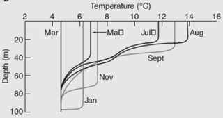
A thermocline is a distinct layer based on temperature within a large body of fluid with a high gradient of distinct temperature differences associated with depth. In the ocean, the thermocline divides the upper mixed layer from the calm deep water below.

Sea surface temperature (SST), or ocean surface temperature, is the ocean temperature close to the surface. The exact meaning of surface varies according to how we measure it. It is between 1 millimetre (0.04 in) and 20 metres (70 ft) below the sea surface. Sea surface temperatures greatly modify air masses in the Earth's atmosphere within a short distance of the shore. Local areas of heavy snow can form in bands downwind of warm water bodies within an otherwise cold air mass. Warm sea surface temperatures can develop and strengthen cyclones over the Ocean. Experts call this process tropical cyclogenesis. Tropical cyclones can also cause a cool wake. This is due to turbulent mixing of the upper 30 metres (100 ft) of the ocean. Sea surface temperature changes during the day. This is like the air above it, but to a lesser degree. There is less variation in sea surface temperature on breezy days than on calm days. Ocean currents, such as the Atlantic Multidecadal Oscillation, can affect sea surface temperatures over several decades. Thermohaline circulation has a major impact on average sea surface temperature throughout most of the world's oceans.
In oceanography, a halocline is a cline, a subtype of chemocline caused by a strong, vertical salinity gradient within a body of water. Because salinity affects the density of seawater, it can play a role in its vertical stratification. Increasing salinity by one kg/m3 results in an increase of seawater density of around 0.7 kg/m3.

A pycnocline is the cline or layer where the density gradient is greatest within a body of water. An ocean current is generated by the forces such as breaking waves, temperature and salinity differences, wind, Coriolis effect, and tides caused by the gravitational pull of celestial bodies. In addition, the physical properties in a pycnocline driven by density gradients also affect the flows and vertical profiles in the ocean. These changes can be connected to the transport of heat, salt, and nutrients through the ocean, and the pycnocline diffusion controls upwelling.
Ocean stratification is the natural separation of an ocean's water into horizontal layers by density, which is generally stable because warm water floats on top of cold water, and heating is mostly from the sun, which reinforces that arrangement. Stratification is reduced by wind-forced mechanical mixing, but reinforced by convection. Stratification occurs in all ocean basins and also in other water bodies. Stratified layers are a barrier to the mixing of water, which impacts the exchange of heat, carbon, oxygen and other nutrients. The surface mixed layer is the uppermost layer in the ocean and is well mixed by mechanical (wind) and thermal (convection) effects. Climate change is causing the upper ocean stratification to increase.
The oceanic or limnological mixed layer is a layer in which active turbulence has homogenized some range of depths. The surface mixed layer is a layer where this turbulence is generated by winds, surface heat fluxes, or processes such as evaporation or sea ice formation which result in an increase in salinity. The atmospheric mixed layer is a zone having nearly constant potential temperature and specific humidity with height. The depth of the atmospheric mixed layer is known as the mixing height. Turbulence typically plays a role in the formation of fluid mixed layers.

The bathythermograph, or BT, also known as the Mechanical Bathythermograph, or MBT; is a device that holds a temperature sensor and a transducer to detect changes in water temperature versus depth down to a depth of approximately 285 meters. Lowered by a small winch on the ship into the water, the BT records pressure and temperature changes on a coated glass slide as it is dropped nearly freely through the water. While the instrument is being dropped, the wire is paid out until it reaches a predetermined depth, then a brake is applied and the BT is drawn back to the surface. Because the pressure is a function of depth, temperature measurements can be correlated with the depth at which they are recorded.
A dimictic lake is a body of freshwater whose difference in temperature between surface and bottom layers becomes negligible twice per year, allowing all strata of the lake's water to circulate vertically. All dimictic lakes are also considered holomictic, a category which includes all lakes which mix one or more times per year. During winter, dimictic lakes are covered by a layer of ice, creating a cold layer at the surface, a slightly warmer layer beneath the ice, and a still-warmer unfrozen bottom layer, while during summer, the same temperature-derived density differences separate the warm surface waters, from the colder bottom waters. In the spring and fall, these temperature differences briefly disappear, and the body of water overturns and circulates from top to bottom. Such lakes are common in mid-latitude regions with temperate climates.

Ocean heat content (OHC) is the energy absorbed and stored by oceans. To calculate the ocean heat content, it is necessary to measure ocean temperature at many different locations and depths. Integrating the areal density of ocean heat over an ocean basin or entire ocean gives the total ocean heat content. Between 1971 and 2018, the rise in ocean heat content accounted for over 90% of Earth’s excess thermal energy from global heating. The main driver of this increase was anthropogenic forcing via rising greenhouse gas emissions. By 2020, about one third of the added energy had propagated to depths below 700 meters. In 2022, the world’s oceans were again the hottest in the historical record and exceeded the previous 2021 record maximum. The four highest ocean heat observations occurred in the period 2019–2022. The North Pacific, North Atlantic, the Mediterranean, and the Southern Ocean all recorded their highest heat observations for more than sixty years. Ocean heat content and sea level rise are important indicators of climate change.
Spice, spiciness, or spicity, symbol τ, is a term in oceanography referring to variations in the temperature and salinity of seawater over space or time, whose combined effects leave the water's density unchanged. For a given spice, any change in temperature is offset by a change in salinity to maintain unchanged density. An increase in temperature decreases density, but an increase in salinity increases density. Such density-compensated thermohaline variability is ubiquitous in the upper ocean. Warmer, saltier water is more spicy while cooler, less salty water is more minty. For a density ratio of 1, all the thermohaline variability is spice, and there are no density fluctuations.
The world ocean (sea) is the body of salt water that covers ~70.8% of the Earth. In English, the term ocean also refers to any of the large bodies of water into which the world ocean is conventionally divided. Distinct names are used to identify five different areas of the ocean: Pacific, Atlantic, Indian, Antarctic/Southern, and Arctic. The ocean contains 97% of Earth's water and is the primary component of the Earth's hydrosphere, thus the ocean essential to life on Earth. The ocean influences climate and weather patterns, the carbon cycle, and the water cycle by acting as a huge heat reservoir.
Ocean dynamics define and describe the flow of water within the oceans. Ocean temperature and motion fields can be separated into three distinct layers: mixed (surface) layer, upper ocean, and deep ocean.

Geophysical fluid dynamics, in its broadest meaning, refers to the fluid dynamics of naturally occurring flows, such as lava flows, oceans, and planetary atmospheres, on Earth and other planets.

Mode water is defined as a particular type of water mass, which is nearly vertically homogeneous. Its vertical homogeneity is caused by the deep vertical convection in winter. The first term to describe this phenomenon is 18° water, which was used by Valentine Worthington to describe the isothermal layer in the northern Sargasso Sea cool to a temperature of about 18 °C each winter. Then Masuzawa introduced the subtropical mode water concept to describe the thick layer of temperature 16–18 °C in the northwestern North Pacific subtropical gyre, on the southern side of the Kuroshio Extension. The terminology mode water was extended to the thick near-surface layer north of the Subantarctic Front by McCartney, who identified and mapped the properties of the Subantarctic mode water (SAMW). After that, McCartney and Talley then applied the term subpolar mode water (SPMW) to the thick near-surface mixed layers in the North Atlantic’s subpolar gyre.
The density ratio of a column of seawater is a measure of the relative contributions of temperature and salinity in determining the density gradient. At a density ratio of 1, temperature and salinity are said to be compensated: their density signatures cancel, leaving a density gradient of zero. The formula for the density ratio, R, is:
Thermohaline staircases are patterns that form in oceans and other bodies of salt water, characterised by step-like structures observed in vertical temperature and salinity profiles; the patterns are formed and maintained by double diffusion of heat and salt. The ocean phenomenon consists of well-mixed layers of ocean water stacked on top of each other. The well-mixed layers are separated by high-gradient interfaces, which can be several meters thick. The total thickness of staircases ranges typically from tens to hundreds of meters.
Mary-Louise Elizabeth Timmermans is a marine scientist known for her work on the Arctic Ocean. She is the Damon Wells Professor of Earth and Planetary Sciences at Yale University.
References
- ↑ Tsuchiya, Mizuki (1986). "Thermostads and circulation in the upper layer of the Atlantic Ocean". Progress in Oceanography. 16 (4): 235–267. Bibcode:1986PrOce..16..235T. doi:10.1016/0079-6611(86)90040-6.
- ↑ Michael S. McCartney (1977). "Subantarctic Mode Water" (PDF). In: A Voyage of Discovery: George Deacon 70th Anniversary Volume, M. V. Angel, editor, Supplement to Deep-Sea Research, Pergamon Press, Oxford, pp. 103-119.: Woods Hole Oceanographic Institute.
{{cite web}}: CS1 maint: location (link) See Publications - Dr. Michael S. McCartney. - ↑ R. Carlton Seitz (Dec 25, 1966). "Thermostad, the Antonym of Thermocline". Journal of Marine Research. 25: 203.
- ↑ "στάδην". Morphologia Graeca. en-academic.com.
- ↑ "Raymond Carlton Seitz Presented with the Albert Nelson Marquis Lifetime Achievement Award by Marquis Who's Who". 24-7 Press Release Newswire. Mar 5, 2019.
| | This oceanography article is a stub. You can help Wikipedia by expanding it. |