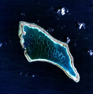
A pseudo-atoll, like an atoll, is an island that encircles a lagoon, either partially or completely. A pseudo-atoll differs from an atoll as established by several authorities, such as how it is formed (not by subsidence, nor by coral). It is considered a preferable term to "near-atoll". There is a need for rigorous definition of "pseudo-atoll" before it can be accepted as a general term.
Alexander Agassiz gave the term pseudo-atoll to "any ring-shaped reefs not formed as a result of subsidence". [1] [2] while Norman D. Newell and J. Keith Rigby [3] called such reefs non-coral. [4] and "We conclude that almost-atoll should be retained as a descriptive term as defined by Davis and Tayama, and that the use of "near-atoll" as a synonym be abandoned. The value of terms such as "semi-atoll" and "pseudo-atoll" needs close examination and more rigorous definition before being generally accepted." H. Mergner yet states that micro-atolls classify as pseudo-atolls. Professor David R. Stoddart of Berkeley states an "almost-atoll" is an atoll with a central island of left over residue.
Dr. Edward J. Petuch, author of Cenozoic seas: the view from eastern North America, refers to pseudo-atolls as pseudoatolls with the Everglades Pseudoatoll as an example. [5]

An atoll, sometimes called a coral atoll, is a ring-shaped coral reef including a coral rim that encircles a lagoon partially or completely. There may be coral islands or cays on the rim. The coral of the atoll often sits atop the rim of an extinct seamount or volcano which has eroded or subsided partially beneath the water. The lagoon forms over the volcanic crater or caldera while the higher rim remains above water or at shallow depths that permit the coral to grow and form the reefs. For the atoll to persist, continued erosion or subsidence must be at a rate slow enough to permit reef growth upward and outward to replace the lost height.

A lagoon is a shallow body of water separated from a larger body of water by barrier islands or reefs. Lagoons are commonly divided into coastal lagoons and atoll lagoons. They have also been identified as occurring on mixed-sand and gravel coastlines. There is an overlap between bodies of water classified as coastal lagoons and bodies of water classified as estuaries. Lagoons are common coastal features around many parts of the world.

A coral reef is an underwater ecosystem characterized by reef-building corals. Reefs are formed of colonies of coral polyps held together by calcium carbonate. Most coral reefs are built from stony corals, whose polyps cluster in groups.

In marine geology, a guyot, also known as a tablemount, is an isolated underwater volcanic mountain (seamount) with a flat top more than 200 m (660 ft) below the surface of the sea. The diameters of these flat summits can exceed 10 km (6.2 mi). Guyots are most commonly found in the Pacific Ocean, but they have been identified in all the oceans except the Arctic Ocean.

A reef is a bar of rock, sand, coral or similar material, lying beneath the surface of water. Many reefs result from natural, abiotic processes—deposition of sand, wave erosion planing down rock outcrops, etc.—but the best known reefs are the coral reefs of tropical waters developed through biotic processes dominated by corals and coralline algae.

Kure Atoll or Ocean Island is an atoll in the Pacific Ocean 48 nautical miles WNW of Midway Atoll in the Northwestern Hawaiian Islands at 28°25′N178°20′W. The only land of significant size is called Green Island and is a habitat for hundreds of thousands of seabirds. A short, unused and unmaintained runway and a portion of one building, both from a former United States Coast Guard LORAN station, are located on the island. Politically, it is part of Hawaii, although separated from the rest of the state by Midway, which is a separate unorganized territory. Green Island, in addition to being the nesting grounds of tens of thousands of seabirds, has recorded several vagrant terrestrial birds including snow bunting, eyebrowed thrush, brambling, olive-backed pipit, black kite, Steller's sea eagle and Chinese sparrowhawk. It is currently managed as a Wildlife Bird Sanctuary by the State of Hawaii's Department of Land and Natural Resource--Division of Forestry and Wildlife as one of the co-trustees of Papahānaumokuākea Marine National Monument with support from Kure Atoll Conservancy.

The Northwestern Hawaiian Islands or Leeward Islands are the small islands and atolls in the Hawaiian island chain located northwest of the islands of Kauai and Niihau. Politically, they are all part of Honolulu County in the U.S. state of Hawaii, except Midway Atoll, which is a territory distinct from Hawaii and grouped as one of the United States Minor Outlying Islands. The United States Census Bureau defines this area, except Midway, as Census Tract 114.98 of Honolulu County. Its total land area is 3.1075 square miles (8.048 km2). All the islands except Nihoa are north of the Tropic of Cancer, making them the only islands in Hawaii that lie outside the tropics.

The Tuamotus, also referred to in English as the Tuamotu Archipelago or the Tuamotu Islands, are a French Polynesian chain of almost 80 islands and atolls forming the largest chain of atolls in the world. This archipelago in the southern Pacific Ocean stretches from the northwest to the southeast over an area roughly the size of Western Europe. The total area of land within this chain is 850 square kilometres, with its major islands being Anaa, Fakarava, Hao and Makemo.

Bokak Atoll or Taongi Atoll is an uninhabited coral atoll in the Ratak Chain of the Marshall Islands, in the North Pacific Ocean. Due to its relative isolation from the main islands in the group, Bokak's flora and fauna has been able to exist in a pristine condition.

A microatoll is a circular colony of coral, dead on the top but living around the perimeter. Growth is mainly lateral, as upward growth is limited by exposure to air. Microatolls may be up to 6 meters (20 ft) in diameter. They are named for their resemblance to island atolls formed during the subsidence of volcanic islands, as originally suggested by Darwin (1842). They act as natural recorders of sea level, which allows the monitoring of sea level changes in response to global warming. They have also been used to quantify and date changes in relative sea level in seismically active areas, and to provide information on changes in sea surface temperature using oxygen isotope values as a proxy.

Toke Atoll or Taka Atoll is a small, uninhabited coral atoll in the Ratak Chain of the Marshall Islands. It is one of the smaller atolls in the Marshalls and located at 11°17′N169°37′E. It is visited regularly by the residents of nearby Utirik Atoll.
The Structure and Distribution of Coral Reefs, Being the first part of the geology of the voyage of the Beagle, under the command of Capt. Fitzroy, R.N. during the years 1832 to 1836, was published in 1842 as Charles Darwin's first monograph, and set out his theory of the formation of coral reefs and atolls. He conceived of the idea during the voyage of the Beagle while still in South America, before he had seen a coral island, and wrote it out as HMS Beagle crossed the Pacific Ocean, completing his draft by November 1835. At the time there was great scientific interest in the way that coral reefs formed, and Captain Robert FitzRoy's orders from the Admiralty included the investigation of an atoll as an important scientific aim of the voyage. FitzRoy chose to survey the Keeling Islands in the Indian Ocean. The results supported Darwin's theory that the various types of coral reefs and atolls could be explained by uplift and subsidence of vast areas of the Earth's crust under the oceans.

The Okeechobean Sea was a Cenozoic eutropical subsea, which along with the Choctaw Sea, occupied the eastern Gulf of Mexico basin system bounding Florida.
The Everglades Pseudoatoll was a major geomorphic feature of southern Florida during the Pliocene epoch.
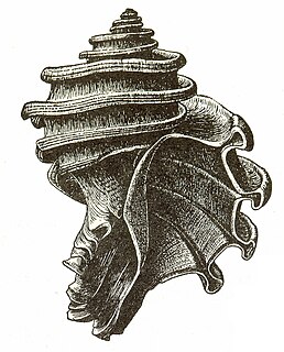
Ecphora is the common name for a group of extinct predatory marine gastropod mollusks within the family Muricidae, the rocks snails or murexes. The common name is based on the first officially described genus, Ecphora. The entire lineage of these ocenebrinid murexes are descended from the Eocene murex, Tritonopsis. Ecphoras are indigenous to the North American Eastern Seaboard, being found in marine strata from the Late Eocene until their extinction during the Pliocene. Many ecphora species are important index fossils.

Wōdejebato is a Cretaceous guyot or tablemount in the northern Marshall Islands, Pacific Ocean. Wōdejebato is probably a shield volcano and is connected through a submarine ridge to the smaller Pikinni Atoll 74 kilometres (46 mi) southeast of the guyot; unlike Wōdejebato, Pikinni rises above sea level. The seamount rises for 4,420 metres (14,500 ft) to 1,335 metres (4,380 ft) depth and is formed by basaltic rocks. The name Wōdejebato refers to a sea god of Pikinni.

Limalok is a Cretaceous-Paleocene guyot/tablemount in the southeastern Marshall Islands, one of a number of seamounts in the Pacific Ocean. It was probably formed by a volcanic hotspot in present-day French Polynesia. Limalok lies southeast of Mili Atoll and Knox Atoll, which rise above sea level, and is joined to each of them through a volcanic ridge. It is located at a depth of 1,255 metres (4,117 ft) and has a summit platform with an area of 636 square kilometres (246 sq mi).
Alexa Bank is a seamount in Samoa, northwest of Rotuma. The seamount reaches a depth of 18–21 metres (59–69 ft) below sea level and has the appearance of an atoll with a flat top and steep slopes. Some active coral growth takes place at its top, but if it ever was an active atoll it has now drowned. It was probably formed by the Samoa hotspot 24 million years ago, although older volcanism about 40 million years ago has also been identified.
Darwin Guyot is a volcanic underwater mountain top, or guyot, in the Mid-Pacific Mountains between the Marshall Islands and Hawaii. Named after Charles Darwin, it rose above sea level more than 118 million years ago during the early Cretaceous period to become an atoll, developed rudist reefs, and then drowned, perhaps as a consequence of sea level rise. The flat top of Darwin Guyot now rests 1,266 metres (4,154 ft) below sea level.
| This article about an island is a stub. You can help Wikipedia by expanding it. |