
The Antarctic Circumpolar Current (ACC) is an ocean current that flows clockwise from west to east around Antarctica. An alternative name for the ACC is the West Wind Drift. The ACC is the dominant circulation feature of the Southern Ocean and has a mean transport estimated at 100–150 Sverdrups, or possibly even higher, making it the largest ocean current. The current is circumpolar due to the lack of any landmass connecting with Antarctica and this keeps warm ocean waters away from Antarctica, enabling that continent to maintain its huge ice sheet.

North Atlantic Deep Water (NADW) is a deep water mass formed in the North Atlantic Ocean. Thermohaline circulation of the world's oceans involves the flow of warm surface waters from the southern hemisphere into the North Atlantic. Water flowing northward becomes modified through evaporation and mixing with other water masses, leading to increased salinity. When this water reaches the North Atlantic it cools and sinks through convection, due to its decreased temperature and increased salinity resulting in increased density. NADW is the outflow of this thick deep layer, which can be detected by its high salinity, high oxygen content, nutrient minima, high 14C/12C, and chlorofluorocarbons (CFCs).

Downwelling is the process of accumulation and sinking of higher density material beneath lower density material, such as cold or saline water beneath warmer or fresher water or cold air beneath warm air. It is the sinking limb of a convection cell. Upwelling is the opposite process, and together, these two forces are responsible in the oceans for the thermohaline circulation. The sinking of the cold lithosphere at subduction zones is another example of downwelling in plate tectonics.

An ocean current is a continuous, directed movement of sea water generated by a number of forces acting upon the water, including wind, the Coriolis effect, breaking waves, cabbeling, and temperature and salinity differences. Depth contours, shoreline configurations, and interactions with other currents influence a current's direction and strength. Ocean currents are primarily horizontal water movements.

Physical oceanography is the study of physical conditions and physical processes within the ocean, especially the motions and physical properties of ocean waters.

The Antarctic bottom water (AABW) is a type of water mass in the Southern Ocean surrounding Antarctica with temperatures ranging from −0.8 to 2 °C (35 °F) and salinities from 34.6 to 34.7 psu. As the densest water mass of the oceans, AABW is found to occupy the depth range below 4000 m of all ocean basins that have a connection to the Southern Ocean at that level.
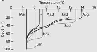
The oceanic or limnological mixed layer is a layer in which active turbulence has homogenized some range of depths. The surface mixed layer is a layer where this turbulence is generated by winds, surface heat fluxes, or processes such as evaporation or sea ice formation which result in an increase in salinity. The atmospheric mixed layer is a zone having nearly constant potential temperature and specific humidity with height. The depth of the atmospheric mixed layer is known as the mixing height. Turbulence typically plays a role in the formation of fluid mixed layers.
The Tasman Outflow is a water pathway connecting water from the Pacific Ocean and the Indian Ocean. The existence of the outflow was published by scientists of the Australian CSIRO's Division of Marine and Atmospheric Research team in August 2007, interpreting salinity and temperature data captured from 1950 to 2002. The Tasman Outflow is seen as the missing link in the supergyre of the Southern Hemisphere and an important part of the thermohaline circulation.
The following outline is provided as an overview of and introduction to Oceanography.
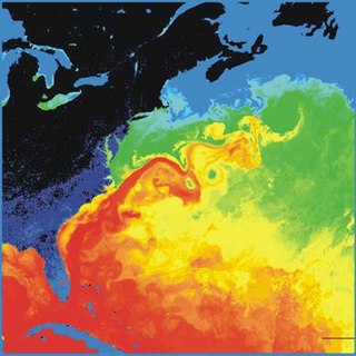
The Gulf Stream, together with its northern extension the North Atlantic Drift, is a warm and swift Atlantic ocean current that originates in the Gulf of Mexico and flows through the Straits of Florida and up the eastern coastline of the United States then veers east near 36 latitude and moves toward Northwest Europe as the North Atlantic Current. The process of western intensification causes the Gulf Stream to be a northwards accelerating current off the east coast of North America. At about 40°0′N30°0′W, it splits in two, with the northern stream, the North Atlantic Drift, crossing to Northern Europe and the southern stream, the Canary Current, recirculating off West Africa.
Antarctic Intermediate Water (AAIW) is a cold, relatively low salinity water mass found mostly at intermediate depths in the Southern Ocean. The AAIW is formed at the ocean surface in the Antarctic Convergence zone or more commonly called the Antarctic Polar Front zone. This convergence zone is normally located between 50°S and 60°S, hence this is where almost all of the AAIW is formed.

The West Spitsbergen Current (WSC) is a warm, salty current that runs poleward just west of Spitsbergen,, in the Arctic Ocean. The WSC branches off the Norwegian Atlantic Current in the Norwegian Sea. The WSC is of importance because it drives warm and salty Atlantic Water into the interior Arctic. The warm and salty WSC flows north through the eastern side of Fram Strait, while the East Greenland Current (EGC) flows south through the western side of Fram Strait. The EGC is characterized by being very cold and low in salinity, but above all else it is a major exporter of Arctic sea ice. Thus, the EGC combined with the warm WSC makes the Fram Strait the northernmost ocean area having ice-free conditions throughout the year in all of the global ocean.

The Barrier layer in the ocean is a layer of water separating the well-mixed surface layer from the thermocline.
In oceanography, a front is a boundary between two distinct water masses. The formation of fronts depends on multiple physical processes and small differences in these lead to a wide range of front types. They can be as narrow as a few hundreds of metres and as wide as several tens of kilometres. While most fronts form and dissipate relatively quickly, some can persist for long periods of time.
Mode water is defined as a particular type of water mass, which is nearly vertically homogeneous. Its vertical homogeneity is caused by the deep vertical convection in winter. The first term to describe this phenomenon is 18° water, which was used by Valentine Worthington to describe the isothermal layer in the northern Sargasso Sea cool to a temperature of about 18 °C each winter. Then Masuzawa introduced the subtropical mode water concept to describe the thick layer of temperature 16–18 °C in the northwestern North Pacific subtropical gyre, on the southern side of the Kuroshio Extension. The terminology mode water was extended to the thick near-surface layer north of the Subantarctic Front by McCartney, who identified and mapped the properties of the Subantarctic mode water (SAMW). After that, McCartney and Talley then applied the term subpolar mode water (SPMW) to the thick near-surface mixed layers in the North Atlantic’s subpolar gyre.
The Brazil–Falkland Confluence Zone is a very energetic region of water just off the coast of Argentina and Uruguay where the warm poleward flowing Brazil Current and the cold equatorward flowing Falkland Current converge. The region oscillates latitudinally, but in general the region of confluence occurs between 35 and 45 degrees south latitude and 50 to 70 degrees west longitude. The confluence of these two currents causes a strong thermohaline to exist and causes numerous high energy eddies to form.
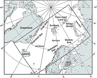
The Nordic Seas are located north of Iceland and south of Svalbard. They have also been defined as the region located north of the Greenland-Scotland Ridge and south of the Fram Strait-Spitsbergen-Norway intersection. Known to connect the North Pacific and the North Atlantic waters, this region is also known as having some of the densest waters, creating the densest region found in the North Atlantic Deep Water. The deepest waters of the Arctic Ocean are connected to the worlds other oceans through Nordic Seas and Fram Strait. There are three seas within the Nordic Sea: Greenland Sea, Norwegian Sea, and Iceland Sea. The Nordic Seas only make up about 0.75% of the World's Oceans. This region is known as having diverse features in such a small topographic area, such as the mid oceanic ridge systems. Some locations have shallow shelves, while others have deep slopes and basins. This region, because of the atmosphere-ocean transfer of energy and gases, has varying seasonal climate. During the winter, sea ice is formed in the western and northern regions of the Nordic Seas, whereas during the summer months, the majority of the region remains free of ice.

The Southern Caribbean Upwelling system (SCUS) is a low latitude tropical upwelling system. Where; due to multiple environmental and bathymetric conditions water from the deep sea is forced to the surface layers of the ocean. The SCUS is located at about 10°N on the southern coast of the Caribbean sea basin off Colombia, Venezuela, and Trinidad.

The Angola - Benguela front (ABF) is a permanent frontal feature situated between 15° and 17°S off the coast of Angola and Namibia, west Africa. It separates the saline, warm and nutrient-poor sea water of the Angola Current from the cold and nutrient-rich sea water associated with the Benguela Current.
The Agulhas Leakage is an inflow of anomalously warm and saline water from the Indian Ocean into the South Atlantic due to the limited latitudinal extent of the African continent compared to the southern extension of the subtropical super gyre in the Indian Ocean. The process occurs during the retroflection of the Agulhas Current via shedding of anticyclonic Agulhas Rings, cyclonic eddies and direct inflow. The leakage contributes to the Atlantic Meridional Overturning Circulation (AMOC) by supplying its upper limb, which has direct climate implications.