
Methane clathrate (CH4·5.75H2O) or (8CH4·46H2O), also called methane hydrate, hydromethane, methane ice, fire ice, natural gas hydrate, or gas hydrate, is a solid clathrate compound (more specifically, a clathrate hydrate) in which a large amount of methane is trapped within a crystal structure of water, forming a solid similar to ice. Originally thought to occur only in the outer regions of the Solar System, where temperatures are low and water ice is common, significant deposits of methane clathrate have been found under sediments on the ocean floors of the Earth. Methane hydrate is formed when hydrogen-bonded water and methane gas come into contact at high pressures and low temperatures in oceans.

A hydrothermal vent is a fissure on the seabed from which geothermally heated water discharges. They are commonly found near volcanically active places, areas where tectonic plates are moving apart at mid-ocean ridges, ocean basins, and hotspots. Hydrothermal deposits are rocks and mineral ore deposits formed by the action of hydrothermal vents.

A cold seep is an area of the ocean floor where hydrogen sulfide, methane and other hydrocarbon-rich fluid seepage occurs, often in the form of a brine pool. Cold does not mean that the temperature of the seepage is lower than that of the surrounding sea water. On the contrary, its temperature is often slightly higher. The "cold" is relative to the very warm conditions of a hydrothermal vent. Cold seeps constitute a biome supporting several endemic species.
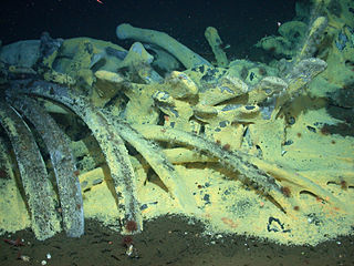
A whale fall occurs when the carcass of a whale has fallen onto the ocean floor at a depth greater than 1,000 m (3,300 ft), in the bathyal or abyssal zones. On the sea floor, these carcasses can create complex localized ecosystems that supply sustenance to deep-sea organisms for decades. This is unlike in shallower waters, where a whale carcass will be consumed by scavengers over a relatively short period of time. Whale falls were first observed in the late 1970s with the development of deep-sea robotic exploration. Since then, several natural and experimental whale falls have been monitored through the use of observations from submersibles and remotely operated underwater vehicles (ROVs) in order to understand patterns of ecological succession on the deep seafloor.

Jason is a two-body remotely operated vehicle (ROV) designed, built, and operated by the National Deep Submergence Laboratory of the Woods Hole Oceanographic Institution (WHOI). Construction of Jason began in 1982 and was first launched in 1988, redesigned in 2002 as the second iteration of the ROV. The ROV allows scientists and explorers to have access to the seafloor without leaving the deck of a ship.

A deep-sea community is any community of organisms associated by a shared habitat in the deep sea. Deep sea communities remain largely unexplored, due to the technological and logistical challenges and expense involved in visiting this remote biome. Because of the unique challenges, it was long believed that little life existed in this hostile environment. Since the 19th century however, research has demonstrated that significant biodiversity exists in the deep sea.

NOAAS Okeanos Explorer is a converted United States Navy ship, now an exploratory vessel for the National Oceanic and Atmospheric Administration (NOAA), officially launched in 2010. Starting in 2010, NOAA entered into a five-year partnership with the San Francisco Exploratorium. The focus is on gathering scientific information about oceans for the public as well as for scientific uses. As much as 95% of the ocean remains unexplored, NOAA officials said. The ship is equipped with cameras and will provide real-time viewing of the ocean floor for scientists and for the public.

Hotspot Ecosystem Research and Man's Impact On European Seas (HERMIONE) is an international multidisciplinary project, started in April 2009, that studies deep-sea ecosystems. HERMIONE scientists study the distribution of hotspot ecosystems, how they function and how they interconnect, partially in the context of how these ecosystems are being affected by climate change and impacted by humans through overfishing, resource extraction, seabed installations and pollution. Major aims of the project are to understand how humans are affecting the deep-sea environment and to provide policy makers with accurate scientific information, enabling effective management strategies to protect deep sea ecosystems. The HERMIONE project is funded by the European Commission's Seventh Framework Programme, and is the successor to the HERMES project, which concluded in March 2009.

Global Explorer ROV is a unique deep water remotely operated vehicle that has made numerous dives below 9,000 feet (2,700 m) on science and survey expeditions for National Geographic, the National Oceanographic and Atmospheric Administration (NOAA) and other research organizations. It was designed and built by Chris Nicholson of Deep Sea Systems International, Inc. of Falmouth, Massachusetts.

A methane chimney or gas chimney is a rising column of natural gas, mainly methane within a water or sediment column. The contrast in physical properties between the gas phase and the surrounding water makes such chimneys visible in oceanographic and geophysical data. In some cases, gas bubbles released at the seafloor may dissolve before they reach the ocean surface, but the increased hydrocarbon concentration may still be measured by chemical oceanographic techniques.

An asphalt volcano is a rare type of submarine volcano (seamount) first discovered in 2003. Several examples have been found: first, along the coasts of the United States and Mexico, and then in other regions of the world; a few are still active. Resembling seamounts in structure, they are made entirely of asphalt, and form when natural oil seeps up from the Earth's crust underwater.

The Campeche Knolls are diapirs rising from a salt deposit in the southern Gulf of Mexico, separated from the Mississippi-Texas-Louisiana salt province by the Sigsbee Abyssal Plain. Located southeast of the Sigsbee Knolls, the Campeche Knolls are bounded by Campeche Bank to the East, the Bay of Campeche to the South, and the salt-free abyssal plain called the Veracruz Tongue to the West. Salt deposition is inferred to have occurred in the Late Jurassic, during the rifting stage of the gulf, equivalent to the Louann Salt of the Texas-Louisiana slope. Multibeam echosounder images collected during R/V Sonne cruise SO174 show the northern Campeche Knolls as distinct, elongated hills that average 3 by 6 mi in size, with reliefs of 1,475 to 2,625 ft and slopes of 10 to 20 percent.
Ocean Networks Canada is a world-leading research and ocean observing facility hosted and owned by the University of Victoria, and managed by the not-for profit ONC Society. ONC operates unparalleled observatories in the deep ocean and coastal waters of Canada’s three coasts–the Arctic, the Pacific and the Atlantic–gathering biological, chemical, geological and physical data to drive solutions for science, industry and society. ONC operates the NEPTUNE and VENUS cabled ocean observatories in the northeast Pacific Ocean and the Salish Sea. Additionally, Ocean Networks Canada operates smaller community-based observatories offshore from Cambridge Bay, Nunavut., Campbell River, Kitamaat Village and Digby Island. These observatories collect data on physical, chemical, biological, and geological aspects of the ocean over long time periods. As with other ocean observatories such as ESONET, Ocean Observatories Initiative, MACHO and DONET, scientific instruments connected to Ocean Networks Canada are operated remotely and provide continuous streams of freely available data to researchers and the public. Over 200 gigabytes of data are collected every day.
The National Centers for Environmental Information (NCEI), an agency of the United States government, manages one of the world's largest archives of atmospheric, coastal, geophysical, and oceanic data, containing information that ranges from the surface of the sun to Earth's core, and from ancient tree ring and ice core records to near-real-time satellite images.

Southern Hydrate Ridge, located about 90 km offshore Oregon Coast, is an active methane seeps site located on the southern portion of Hydrate Ridge. It extends 25 km in length and 15 km across, trending north-northeast-south-southwest at the depth of approximately 800 m. Southern Hydrate Ridge has been the site of numerous submersible dives with the human occupied Alvin submarine, extensive visits by numerous robotic vehicles including the Canadian ROV ROPOS, Jason , and Tiburon (MBARI), and time-series geophysical studies that document changes in the subsurface distribution of methane. It is also a key site of the National Science Foundations Regional Cabled Array that is part of the Ocean Observatories Initiative (OOI), which includes eight types of cabled instruments streaming live data back to shore 24/7/365 at the speed of light, as well as uncabled instruments.

This expedition was the final of three expeditions on the NOAAS Okeanos Explorer intended to increase the understanding of the deep-sea environment in the Gulf of Mexico. Gulf of Mexico 2018 was a 23-day telepresence-enabled expedition to collect critical information and acquire data on priority exploration areas identified by the ocean management and scientific communities. The goal of the expedition was to use remotely operated vehicle (ROV) dives in combination with seafloor mapping operations to increase the understanding of deep-sea ecosystems and collect scientific information to support future management decisions. The expedition lasted from 11 April 2018 to 3 May 2018.

Heceta Bank is a rocky bank located 55 kilometers (km) off the Oregon coast near Florence, centered on approximately 44°N, 125°W, and is roughly 29 km long and upwards of 13 km wide. Heceta Bank is an area of ecological and oceanographic importance. The unique bathymetric features and seasonal circulation within the bank provides habitat for a diversity of economically-important fish species.

The Von Damm Hydrothermal Field is a field of hydrothermal vents located just south of Grand Cayman in the Caribbean, on the Mid-Cayman Rise in the Cayman Trough. It is approximately 24 kilometres (15 mi) south of the Beebe Vent Field. The vent field is named in commemoration of geochemical oceanographer Karen Von Damm, who died in 2008.
Bottom simulating reflectors (BSRs) are, on seismic reflection profiles, shallow seismic reflection events, characterized by their reflection geometry similar to seafloor bathymetry. . They have, however, the opposite reflection polarity to the seabed reflection, and frequently intersect the primary reflections.

Daikoku Seamount is a submarine volcano located in the Northern Mariana Islands, in the western Pacific Ocean. It is part of a chain of volcanoes and seamounts that includes the more known Ahyi Seamount and NW Rota-1 seamounts and is situated about 690 km (429 mi) north of the island of Saipan. Daikoku Seamount rises over 2,500 m (8,202 ft) meters from the seafloor, with its summit about 323 m (1,060 ft) below sea level. Since its discovery, the seamount has been studied by several expeditions, including expeditions made by NOAA, using various scientific tools, such as sonar mapping and remotely operated vehicles (ROVs). Daikoku Seamount is known for its active hydrothermal vent system, which hosts diverse communities of deep-sea organisms, including tube worms, crabs, and snails. The seamount is also one of the only volcanoes along with Nikkō Seamount to have had a partially molten sulfur lake, which is usually a feature seen on Io than on Earth.


