Related Research Articles

Stromatolites or stromatoliths are layered sedimentary formations (microbialite) that are created mainly by photosynthetic microorganisms such as cyanobacteria, sulfate-reducing bacteria, and Pseudomonadota. These microorganisms produce adhesive compounds that cement sand and other rocky materials to form mineral "microbial mats". In turn, these mats build up layer by layer, growing gradually over time. A stromatolite may grow to a meter or more. Although they are rare today, fossilized stromatolites provide records of ancient life on Earth.

William Maurice "Doc" Ewing was an American geophysicist and oceanographer.

The geology of the Grand Canyon area includes one of the most complete and studied sequences of rock on Earth. The nearly 40 major sedimentary rock layers exposed in the Grand Canyon and in the Grand Canyon National Park area range in age from about 200 million to nearly 2 billion years old. Most were deposited in warm, shallow seas and near ancient, long-gone sea shores in western North America. Both marine and terrestrial sediments are represented, including lithified sand dunes from an extinct desert. There are at least 14 known unconformities in the geologic record found in the Grand Canyon.

William Diller Matthew FRS was a vertebrate paleontologist who worked primarily on mammal fossils, although he also published a few early papers on mineralogy, petrological geology, one on botany, one on trilobites, and he described Tetraceratops insignis, which was much later suggested to be the oldest known therapsid.

A turbidite is the geologic deposit of a turbidity current, which is a type of amalgamation of fluidal and sediment gravity flow responsible for distributing vast amounts of clastic sediment into the deep ocean.
The Bimini Road, sometimes called the Bimini Wall, is an underwater rock formation near North Bimini island in the Bahamas. The Road consists of a 0.8 km (0.50 mi)-long northeast-southwest linear feature composed of roughly rectangular to subrectangular limestone blocks. Various claims have been made for this feature being either a wall, road, pier, breakwater, or other man-made structure. However, credible evidence or arguments are lacking for such an origin.

A submarine canyon is a steep-sided valley cut into the seabed of the continental slope, sometimes extending well onto the continental shelf, having nearly vertical walls, and occasionally having canyon wall heights of up to 5 km, from canyon floor to canyon rim, as with the Great Bahama Canyon. Just as above-sea-level canyons serve as channels for the flow of water across land, submarine canyons serve as channels for the flow of turbidity currents across the seafloor. Turbidity currents are flows of dense, sediment laden waters that are supplied by rivers, or generated on the seabed by storms, submarine landslides, earthquakes, and other soil disturbances. Turbidity currents travel down slope at great speed, eroding the continental slope and finally depositing sediment onto the abyssal plain, where the particles settle out.
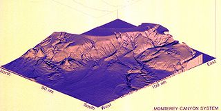
Monterey Canyon, or Monterey Submarine Canyon, is a submarine canyon in Monterey Bay, California with steep canyon walls measuring a full 1 mile in height from bottom to top, which height/depth rivals the depth of the Grand Canyon itself. It is the largest such submarine canyon along the West coast of the North American continent, and was formed by the underwater erosion process known as turbidity current erosion. Many questions remain unresolved regarding the exact nature of its origins, and as such it is the subject of several ongoing geological and marine life studies being carried out by scientists stationed at the nearby Monterey Bay Aquarium Research Institute, the Moss Landing Marine Laboratories, and other oceanographic institutions.
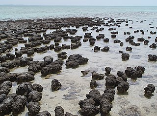
The Hamelin Pool Marine Nature Reserve is a protected marine nature reserve located in the UNESCO World Heritage–listed Shark Bay in the Gascoyne region of Western Australia. The 127,000-hectare (310,000-acre) nature reserve boasts the most diverse and abundant examples of living marine stromatolites in the world, monuments to life on Earth over 3,500 million years BP.

Hotspot Ecosystem Research and Man's Impact On European Seas (HERMIONE) is an international multidisciplinary project, started in April 2009, that studies deep-sea ecosystems. HERMIONE scientists study the distribution of hotspot ecosystems, how they function and how they interconnect, partially in the context of how these ecosystems are being affected by climate change and impacted by humans through overfishing, resource extraction, seabed installations and pollution. Major aims of the project are to understand how humans are affecting the deep-sea environment and to provide policy makers with accurate scientific information, enabling effective management strategies to protect deep sea ecosystems. The HERMIONE project is funded by the European Commission's Seventh Framework Programme, and is the successor to the HERMES project, which concluded in March 2009.
The Lynx Formation or Lynx Group is a stratigraphic unit of Late Cambrian (Dresbachian) age in the Western Canada Sedimentary Basin. It is present in the Canadian Rockies of Alberta and British Columbia. It was originally described as the Lynx Formation by Charles Doolittle Walcott in 1913, based on and named for outcrops on the slopes of Lynx Mountain on the continental divide east of Mount Robson. It was subdivided into five formations and elevated to group status by J.D. Aitken and R.G. Greggs in 1967. The name Lynx Formation continues to be used in areas where some or all of the subdivisions cannot be distinguished. All of the formations in the Lynx Group include fossil trilobites and some contain the stromatolite Collenia.

The Cathedral Formation is a stratigraphic unit in the southern Canadian Rockies of Alberta and British Columbia, on the western edge of the Western Canada Sedimentary Basin. It is a thick sequence of carbonate rocks of Middle Cambrian age. It was named for Cathedral Mountain in Yoho National Park by Charles Doolittle Walcott, the discoverer of the Burgess shale fossils.

Sandfall is a term applied to a variety of forms of sedimentary transport or sedimentary features belonging to the larger category of mass wasting, and are driven by wind, water currents and gravitational forces.

The Unkar Group is a sequence of strata of Proterozoic age that are subdivided into five geologic formations and exposed within the Grand Canyon, Arizona, Southwestern United States. The 5-unit Unkar Group is the basal member of the 8-member Grand Canyon Supergroup. The Unkar is about 1,600 to 2,200 m thick and composed, in ascending order, of the Bass Formation, Hakatai Shale, Shinumo Quartzite, Dox Formation, and Cardenas Basalt. Units 4 & 5 are found mostly in the eastern region of Grand Canyon. Units 1 through 3 are found in central Grand Canyon. The Unkar Group accumulated approximately between 1250 and 1104 Ma. In ascending order, the Unkar Group is overlain by the Nankoweap Formation, about 113 to 150 m thick; the Chuar Group, about 1,900 m (6,200 ft) thick; and the Sixtymile Formation, about 60 m (200 ft) thick. These are all of the units of the Grand Canyon Supergroup. The Unkar Group makes up approximately half of the thickness of the 8-unit Supergroup.

The Bass Formation, also known as the Bass Limestone, is a Mesoproterozoic rock formation that outcrops in the eastern Grand Canyon, Coconino County, Arizona. The Bass Formation erodes as either cliffs or stair-stepped cliffs. In the case of the stair-stepped topography, resistant dolomite layers form risers and argillite layers form steep treads. In general, the Bass Formation in the Grand Canyon region and associated strata of the Unkar Group-rocks dip northeast (10°–30°) toward normal faults that dip 60+° toward the southwest. This can be seen at the Palisades fault in the eastern part of the main Unkar Group outcrop area. In addition, thick, prominent, and dark-colored basaltic sills intrude across the Bass Formation.
San Lucas Canyon is a submarine canyon off Cabo San Lucas, Baja California Sur. The canyon is home to some spectacular submarine phenomena, namely the "rivers of sand" and sandfalls. These were first observed in 1959 by an expedition led by D. F. Shepard and including Conrad Limbaugh, James Steward, and Wheeler J. North. These features were documented by Robert F. Dill (1964) and dived, filmed and made famous by Jacques Cousteau.
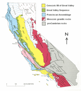
The Great Valley Sequence of California is a 40,000-foot (12 km)-thick group of related geologic formations that are Late Jurassic through Cretaceous in age on the geologic time scale. These sedimentary rocks were deposited during the late Mesozoic Era in an ancient seaway that corresponds roughly to the outline of the modern Great Valley of California.
Titanic Canyon is a submarine canyon located south of the Grand Banks of Newfoundland, Canada. Its name was proposed in 1991 by marine geologist Alan Ruffman in remembrance of British passenger liner RMS Titanic, the wreck of which lies about 34 km (21 mi) south of the head of Titanic Canyon on its eastern slope.
Lee Stocking Island is an island in the Bahamas, located in the district of Exuma.
References
- ↑ Shinn, Eugene A. (2004) Memorials: Robert F. Dill (1927-2004) American Association of Petroleum Geologists Bulletin, Vol. 88, No 12 December p1705-6
| | This biographical article about a geologist is a stub. You can help Wikipedia by expanding it. |