North German basin

Last updated
The North German Basin located in western Europe, represented as the green region defined by USGS NGB Locality Map finished.png
The North German Basin located in western Europe, represented as the green region defined by USGS

The North German Basin is a passive-active rift basin located in central and west Europe, lying within the southeasternmost portions of the North Sea and the southwestern Baltic Sea and across terrestrial portions of northern Germany, Netherlands, and Poland. [1] The North German Basin is a sub-basin of the Southern Permian Basin, that accounts for a composite of intra-continental basins composed of Permian to Cenozoic sediments, which have accumulated to thicknesses around 10–12 kilometres (6–7.5 mi). [2] [3] The complex evolution of the basin takes place from the Permian to the Cenozoic, and is largely influenced by multiple stages of rifting, subsidence, and salt tectonic events. The North German Basin also accounts for a significant amount of Western Europe's natural gas resources, including one of the world's largest natural gas reservoir, the Groningen gas field. [4]

Contents

Regional tectonic evolution

The regional tectonic evolution of the North German Basin coincides with of the evolution of the Southern Permian Basin, the basin across central and western Europe. From the late Neoproterozoic Era to Carboniferous Period, Europe underwent the Caledonian Orogeny and Variscan Orogeny.[ citation needed ] These crustal accretion events produced the present day regional lithosphere, and by the time of the post-orogenic collapse of the Variscan Orogeny the supercontinent Pangea had completely formed. [5] After the formation of Pangea, much of the region underwent crustal instability and thus developing the extensive Permo-Carboniferous magmatic province. [6] This magmatism led to the extrusion of abundant volcanic successions such as the Northeast German Basin, Northwest Polish Basin, and Oslo Rift, while also causing the formation of 70 rift basins throughout the Permian Basin. [5] The regions most evolved and voluminous magmatism occurred within the North German Basin dating back to 297-302 Ma. [7]

Basin evolution

Initial rifting

The initiation of the Northern German Basin took place in the Late Carboniferous approximately 295-285 Ma (Million Years Ago) in association collapse of the Variscan Orogeny due to wrenching tectonics in the over-thickened crust in the northern foreland of the Variscan Orogeny. [8] [9] [10] The initiation formed by crustal rifting and wrenching in addition to huge amounts of volcanism(>40,000 km3 ) and magmatism, can only be approximately dated due to the extensive (>250 Ma) poly-phased subsidence of the region. [2] The most evident dating method has been done using SHRIMP (Sensitive High-Resolution Ion Microprobe) Zircon ages, allowing for dating of sediments produced during the magmatic flare-up during the Permian. [7] The wrench tectonics, magmatic inflation, and mantle lithosphere erosion took place gave a regional uplift allowing for an increase in crustal erosion. [10]

Main phase of subsidence

20 million years post-rifting, the North German Basin experienced a rapid accumulation of sediments, >2,700 m (8,900 ft) of strata from the Upper Rotliegend Unit to the Bunter Unit, thus experiencing maximum thermal subsidence from the Late Permian to the Middle Triassic. [2] [11] This rapid burial of sediments lead to subsidence rates of 220 m per million years due to the drastic increase in crustal load. [11] Another important influence of this subsidence is due to the thermal relaxation of the lithospheric magmatic inflation, thus allowing the basin to deepen with the accumulation of the sediment.[ citation needed ]

Secondary rifting

During the Triassic-Early Jurassic, 252 to 200 Ma, there was a phase of new north to south rifting events due to the break up of the super-continent Pangea caused W-E extension across the Northern German Basin.[ citation needed ] These extensions in the crust created the Triassic grabens such as the local the Gluckstadt Graben, while also initiating the salt tectonics seen in the region. [2] This rifting event was then followed by another phase of subsidence due to sedimentary loading and lithospheric thermal relaxation.[ citation needed ]

Doming

During the Middle-Late Jurassic, the center of the North Sea underwent a doming acknowledged by the Middle Jurassic erosional unconformity, the erosion of >1,000 m (3,300 ft) of Upper Triassic and Lower Jurassic strata. [12] The dome raised above sea level during the Middle Jurassic and began to deflate due to rifting in the Late Jurassic. [13] Though the mechanism forming the North Sea Rift Dome is not particularly well understood, the development of the dome seems to be consistent with an active rift model having a broad-based (1,250 km or 780 mi diameter) plume head influencing the Late Jurassic rifting. [14]

Tertiary rifting

In the Late Jurassic, the third rifting event took place in response to the North Sea doming event. Major extensional faulting and rifting began approximately 157-155 Ma allowing for the Zechstein evaporites to form a detachment between basement rocks and upper stratigraphy largely influencing the natural gas and oil formation seen across the North German Basin. Organic-rich mudstones from the Kimmeridge Clay Formation is the source of the majority of the North German Basin's hydrocarbons which was restricted from migrating upward by the Zechstein salt.[ citation needed ]

Inversion

In the Late Cretaceous, a significant phase of inversion took place due to the reactivation of strike-slip basement faults. [12] Inversion of the region responded significantly to the orientation of compression, such that faults like the E-W Elbe Fault System was inverted 3–4 km (1.9–2.5 mi) while the N-S Grabens did not experience significant uplift. [2]

Final subsidence

During the Cenozoic, the last phase of subsidence occurred. During the Oligocene to Miocene, many of the basement faults were reactivated by the strike-slip faults during the Late Cretaceous inversion. The reactivation of these basement faults triggered more halokinesis. [11] [12] Slight inversion due to the salt tectonics allowed for minor amounts of Miocene and Pliocene deposits, which were later buried by widespread delta and glacial deposits during the Quaternary, resulting in rapid subsidence. [1] [12]

Stratigraphy

This figure breaks down the stratigraphic units of the North German Basin through time. North German Basin Stratigraphy Column.jpg
This figure breaks down the stratigraphic units of the North German Basin through time.

The depositional history of the North German Basin is recorded within the stratigraphy sequence of sediments, which make up the basin. The poly-phase deposition of the basin can be broken down into strati-graphic units, each with their own distinct characteristics. The sedimentary basin was assembled above the Lower Paleozoic crystalline basement formed during the Caledonian Orogeny about 420-400 Ma. [15]

Paleozoic era

Mesozoic era

Cenozoic era

Energy resources

The North German Basin has a particularly abundance of natural gas. These large hydrocarbon accumulations have been created and clumped together by a single total petroleum system (TPS) called the Carboniferous-Rotliegend TPS. [4] Approximately 85% of all gas production has been from the Rotliegend Group aeolian sandstones preserved by the Zechstein Unit, while 13% can be contributed to the Triassic fluvial sandstones, also preserved by the Zechstein Unit but due to the migration of salt rather than chronologically being placed below the Zechstein Unit. [12] The Groningen Gas Field is the located below a region northeast Netherland is the basins largest reserve and also happens to be one of the largest gas fields in the world holding up to 100 trillion cubic feet (2.8×10^12 m3) of natural gas. The North German Basin along with the Anglo-Dutch Basin and the North Sea Graben Province, contain the majority of oil and gas reserves identified throughout Western Europe.[ citation needed ]

Related Research Articles

<span class="mw-page-title-main">Geology of India</span> Geological origins and structure of India

The geology of India is diverse. Different regions of India contain rocks belonging to different geologic periods, dating as far back as the Eoarchean Era. Some of the rocks are very deformed and altered. Other deposits include recently deposited alluvium that has yet to undergo diagenesis. Mineral deposits of great variety are found in the Indian subcontinent in huge quantities. Even India's fossil record is impressive in which stromatolites, invertebrates, vertebrates and plant fossils are included. India's geographical land area can be classified into the Deccan Traps, Gondwana and Vindhyan.

<span class="mw-page-title-main">Geology of Australia</span> Overview of the geology of Australia

The geology of Australia includes virtually all known rock types, spanning a geological time period of over 3.8 billion years, including some of the oldest rocks on earth. Australia is a continent situated on the Indo-Australian Plate.

The geology of the Netherlands describes the geological sequence of the Netherlands. Large parts of the Netherlands today are below sea level and have in the past been covered by the sea or flooded at regular intervals. The modern Netherlands formed as a result of the interplay of the four main rivers and the influence of the North Sea and glaciers during ice-ages. The Netherlands is mostly composed of deltaic, coastal and eolian derived sediments during the Pleistocene glacial and interglacial periods.

<span class="mw-page-title-main">Geology of England</span> Overview of the geology of England

The geology of England is mainly sedimentary. The youngest rocks are in the south east around London, progressing in age in a north westerly direction. The Tees–Exe line marks the division between younger, softer and low-lying rocks in the south east and the generally older and harder rocks of the north and west which give rise to higher relief in those regions. The geology of England is recognisable in the landscape of its counties, the building materials of its towns and its regional extractive industries.

<span class="mw-page-title-main">Geology of the Iberian Peninsula</span> Origins, structure, use and study of the rock formations of Spain, Portugal, Andorra and Gibraltar

The geology of the Iberian Peninsula consists of the study of the rock formations on the Iberian Peninsula, which includes Spain, Portugal, Andorra, and Gibraltar. The peninsula contains rocks from every geological period from the Ediacaran to the Quaternary, and many types of rock are represented. World-class mineral deposits are also found there.

<span class="mw-page-title-main">Geology of the North Sea</span> Description of the current geological features and the geological history that created them

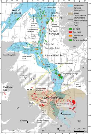
The geology of the North Sea describes the geological features such as channels, trenches, and ridges today and the geological history, plate tectonics, and geological events that created them.

The Rotliegend, Rotliegend Group or Rotliegendes is a lithostratigraphic unit of latest Carboniferous to Guadalupian age that is found in the subsurface of large areas in western and central Europe. The Rotliegend mainly consists of sandstone layers. It is usually covered by the Zechstein and lies on top of regionally different formations of late Carboniferous age.

The Cheshire Basin is a late Palaeozoic and Mesozoic sedimentary basin extending under most of the county of Cheshire in northwest England. It extends northwards into the Manchester area and south into Shropshire. The basin possesses something of the character of a half-graben as its deepest extent is along its eastern and southeastern margins, where it is well defined by a series of sub-parallel faults, most important of which is the Red Rock Fault. These faults divide the basin from the older Carboniferous rocks of the Peak District and the North Staffordshire Coalfield.

<span class="mw-page-title-main">Geology of the Pyrenees</span> European regional geology

The Pyrenees are a 430-kilometre-long, roughly east–west striking, intracontinental mountain chain that divide France, Spain, and Andorra. The belt has an extended, polycyclic geological evolution dating back to the Precambrian. The chain's present configuration is due to the collision between the microcontinent Iberia and the southwestern promontory of the European Plate. The two continents were approaching each other since the onset of the Upper Cretaceous (Albian/Cenomanian) about 100 million years ago and were consequently colliding during the Paleogene (Eocene/Oligocene) 55 to 25 million years ago. After its uplift, the chain experienced intense erosion and isostatic readjustments. A cross-section through the chain shows an asymmetric flower-like structure with steeper dips on the French side. The Pyrenees are not solely the result of compressional forces, but also show an important sinistral shearing.

The Zonguldak basin of northwestern Turkey is the only basin in Turkey with mineable coal deposits. It has been mined for coal since the late 1800s. The basin takes its name after Zonguldak, Turkey, and lies at approximately 41° N. It is roughly elliptical in shape with its long axis oriented roughly southwest to northeast, and is adjacent to the Black Sea. Three main regions have been recognized in the Zonguldak basin: from west to east, Armutcuk, Zonguldak, and Amasra.

<span class="mw-page-title-main">Geology of Iran</span>

The main points that are discussed in the geology of Iran include the study of the geological and structural units or zones; stratigraphy; magmatism and igneous rocks; ophiolite series and ultramafic rocks; and orogenic events in Iran.

<span class="mw-page-title-main">Northern North Sea basin</span>

The North Sea is part of the Atlantic Ocean in northern Europe. It is located between Norway and Denmark in the east, Scotland and England in the west, Germany, the Netherlands, Belgium and France in the south.

The Exmouth Plateau is an elongate northeast striking extensional passive margin located in the Indian Ocean roughly 3,000 meters offshore from western and northwestern Western Australia.

<span class="mw-page-title-main">Geology of the southern North Sea</span> Largest gas producing basin

The North Sea basin is located in northern Europe and lies between the United Kingdom, and Norway just north of The Netherlands and can be divided into many sub-basins. The Southern North Sea basin is the largest gas producing basin in the UK continental shelf, with production coming from the lower Permian sandstones which are sealed by the upper Zechstein salt. The evolution of the North Sea basin occurred through multiple stages throughout the geologic timeline. First the creation of the Sub-Cambrian peneplain, followed by the Caledonian Orogeny in the late Silurian and early Devonian. Rift phases occurred in the late Paleozoic and early Mesozoic which allowed the opening of the northeastern Atlantic. Differential uplift occurred in the late Paleogene and Neogene. The geology of the Southern North Sea basin has a complex history of basinal subsidence that had occurred in the Paleozoic, Mesozoic, and Cenozoic. Uplift events occurred which were then followed by crustal extension which allowed rocks to become folded and faulted late in the Paleozoic. Tectonic movements allowed for halokinesis to occur with more uplift in the Mesozoic followed by a major phase of inversion occurred in the Cenozoic affecting many basins in northwestern Europe. The overall saucer-shaped geometry of the southern North Sea Basin indicates that the major faults have not been actively controlling sediment distribution.

<span class="mw-page-title-main">Lhasa terrane</span> Fragment of crustal material that forms present-day southern Tibet

The Lhasa terrane is a terrane, or fragment of crustal material, sutured to the Eurasian Plate during the Cretaceous that forms present-day southern Tibet. It takes its name from the city of Lhasa in the Tibet Autonomous Region, China. The northern part may have originated in the East African Orogeny, while the southern part appears to have once been part of Australia. The two parts joined, were later attached to Asia, and then were impacted by the collision of the Indian Plate that formed the Himalayas.

<span class="mw-page-title-main">Geology of Germany</span> Overview of the geology of Germany

The geology of Germany is heavily influenced by several phases of orogeny in the Paleozoic and the Cenozoic, by sedimentation in shelf seas and epicontinental seas and on plains in the Permian and Mesozoic as well as by the Quaternary glaciations.

<span class="mw-page-title-main">Wessex Basin</span> Petroliferous geological area on the southern coast of England and the English Channel

The Wessex Basin is a petroleum-bearing geological area located along the southern coast of England and extending into the English Channel. The onshore part of the basin covers approximately 20,000 km2 and the area that encompasses the English Channel is of similar size. The basin is a rift basin that was created during the Permian to early Cretaceous in response to movement of the African plate relative to the Eurasian plate. In the late Cretaceous, and again in the Cenozoic, the basin was inverted as a distant effect of the Alpine orogeny. The basin is usually divided into 3 main sub-basins including the Winterborne-Kingston Trough, Channel Basin, and Vale of Pewsey Basin. The area is also rich in hydrocarbons with several offshore wells in the area. With the large interest in the hydrocarbon exploration of the area, data became more readily available, which improved the understanding of the type of inversion tectonics that characterize this basin.

<span class="mw-page-title-main">Geology of Italy</span> Overview of the geology of Italy

The geology of Italy includes mountain ranges such as the Alps and the Apennines formed from the uplift of igneous and primarily marine sedimentary rocks all formed since the Paleozoic. Some active volcanoes are located in Insular Italy.

<span class="mw-page-title-main">Junggar Basin</span> Sedimentary basin in Xinjiang, China

The Junggar Basin, also known as the Dzungarian Basin or Zungarian Basin, is one of the largest sedimentary basins in Northwest China. It is located in Dzungaria in northern Xinjiang, and enclosed by the Tarbagatai Mountains of Kazakhstan in the northwest, the Altai Mountains of Mongolia in the northeast, and the Heavenly Mountains in the south. The geology of Junggar Basin mainly consists of sedimentary rocks underlain by igneous and metamorphic basement rocks. The basement of the basin was largely formed during the development of the Pangea supercontinent during complex tectonic events from Precambrian to late Paleozoic time. The basin developed as a series of foreland basins – in other words, basins developing immediately in front of growing mountain ranges – from Permian time to the Quaternary period. The basin's preserved sedimentary records show that the climate during the Mesozoic era was marked by a transition from humid to arid conditions as monsoonal climatic effects waned. The Junggar basin is rich in geological resources due to effects of volcanism and sedimentary deposition. According to Guinness World Records it is a land location remotest from open sea with great-circle distance of 2,648 km from the nearest open sea at 46°16′8″N86°40′2″E.

<span class="mw-page-title-main">Parnaíba Basin</span>

The Parnaíba Basin is a large cratonic sedimentary basin located in the North and Northeast portion of Brazil. About 50% of its areal distribution occurs in the state of Maranhão, and the other 50% occurring in the state of Pará, Piauí, Tocantins, and Ceará. It is one of the largest Paleozoic basins in the South American Platform. The basin has a roughly ellipsoidal shape, occupies over 600,000 km2, and is composed of ~3.4 km of mainly Paleozoic sedimentary rock that overlies localized rifts.

References

  1. 1 2 Hubscher, C. (October 28, 2009). "Structure and evolution of the Northeastern German Basin and its transition onto the Baltic Shield". Marine and Petroleum Geology . 27 (4): 923–938. doi:10.1016/j.marpetgeo.2009.10.017.
  2. 1 2 3 4 5 6 7 8 9 10 11 12 13 14 Scheck, M. (November 1999). "Evolution of the Northeast German Basin — inferences from a 3D structural model and subsidence analysis". Tectonophysics. 313 (1–2): 145–169. Bibcode:1999Tectp.313..145S. doi:10.1016/s0040-1951(99)00194-8.
  3. Gemmer, Lykke (September 2002). "Late Cretaceous–Cenozoic evolution of the North German Basin—results from 3-D geodynamic modelling". Tectonophysics. 373 (1–4): 39–54. doi:10.1016/s0040-1951(03)00282-8.
  4. 1 2 Gautier, Donald L. (2003). "Carboniferous-Rotliegend Total Petroleum System Description and Assessment Results Summary". U.S. Geological Survey (2211).
  5. 1 2 McCann, T. "Post-Variscan (end Carboniferous –Early Permian) basin evolution in Western and Central Europe". Geological Survey of Norway.
  6. Scheck-Wenderoth, Magdalena (December 2004). "Crustal memory and basin evolution in the Central European Basin System—new insights from a 3D structural model". Tectonophysics. 397 (1–2): 143–165. doi:10.1016/j.tecto.2004.10.007.
  7. 1 2 Breitkreuz, C. (1999). "Magmatic flare-up at the Carboniferous–Permian boundary in the NE German Basin revealed by SHRIMP zircon ages". Tectonophysics. 302 (3–4): 307–326. Bibcode:1999Tectp.302..307B. doi:10.1016/s0040-1951(98)00293-5.
  8. Ziegler, Peter (1993). "Late Palaeozoic — Early Mesozoic Plate Reorganization: Evolution and Demise of the Variscan Fold Belt". Pre-Mesozoic Geology in the Alps: 203–216. doi:10.1007/978-3-642-84640-3_12. ISBN   978-3-642-84642-7.
  9. 1 2 3 Brink, Heinz-Juergen (2005). "The evolution of the North German Basin and the metamorphism of the lower crust". International J Earth Science (Geol Rundsch). 94 (5–6): 1103–1116. Bibcode:2005IJEaS..94.1103B. doi:10.1007/s00531-005-0037-7.
  10. 1 2 Van Wees, J.D. (2000). "On the origin of Southern Permian Basin, Central Europe". Marine and Petroleum Geology. 17 (1): 43–59. Bibcode:2000MarPG..17...43V. doi:10.1016/s0264-8172(99)00052-5.
  11. 1 2 3 Glennie, K.W. (1995). "Permian and Triassic rifting in northwest Europe". Geological Society Special Publication. 91 (1): 1–5. Bibcode:1995GSLSP..91....1G. doi:10.1144/gsl.sp.1995.091.01.01.
  12. 1 2 3 4 5 Balson, Peter (2001). "NORTH SEA GEOLOGY". British Geological Survey.
  13. Graversen, Ole (2006). "The Jurassic-Cretaceous North Sea Rift Dome and Associated Basin Evolution". Search and Discovery Article.
  14. Underhill, J.R. (1993). "Jurassic thermal doming and deflation in the North Sea: implications of the sequence stratigraphic evidence". Petroleum Geology Conference Series. 4: 337–345. doi:10.1144/0040337.
  15. Sajjad, Noman (2013). "Structural restoration of Mesozoic rifting phases in the northern North Sea". Petroleum Geosciences.
  16. 1 2 George, Gareth (1993). "A new lithostratigraphy and depositional model for the Upper Rotliegend of the UK Sector of the Southern North Sea". Geological Society Special Publications. 73 (1): 291–319. Bibcode:1993GSLSP..73..291G. doi:10.1144/gsl.sp.1993.073.01.18.
  17. Mazur, Stanislaw (2005). "Different modes of the Late Cretaceous Early- Tertiary inversion in the North German and Polish Basins". International Earth Science. 94 (5–6): 782–798. Bibcode:2005IJEaS..94..782M. doi:10.1007/s00531-005-0016-z.
  18. Kyrkjebo, Rune (2004). "Unconformities related to the Jurassic–Cretaceous synrift–post-rift transition of the northern North Sea". Journal of the Geological Society. 161 (1): 1–17. Bibcode:2004JGSoc.161....1K. doi:10.1144/0016-764903-051.
  19. Rawson, P.F. (1982). "Latest Jurassic - Early Cretaceous Events and the "Late Cimmerian Unconformity" in North Sea Area". AAPG Bulletin. 66: 2628 of 2648. doi:10.1306/03b5ac87-16d1-11d7-8645000102c1865d.
  20. Johansen, Steven (1994). "A Genetic Stratigraphy for the Valhall Formation (Cretaceous), Outer Moray Firth, UK Sector, North Sea". AAPG Datapages. Article #90986.
  21. Milmsen, Markus (2003). "Sequence stratigraphy and palaeoceanography of the Cenomanian Stage in northern Germany". Cretaceous Research. 24 (5): 525–568. Bibcode:2003CrRes..24..525W. doi:10.1016/s0195-6671(03)00069-7.
  22. Berggren, William (2007). "A Cenozoic time-scale — some implications for regional geology and paleobiogeography". Lethaia. 5 (2): 195–215. doi:10.1111/j.1502-3931.1972.tb00852.x.
  23. Cameron, T.D. (1987). "The history of Quaternary sedimentation in the UK sector of the North Sea Basin". Journal of the Geological Society. 144 (1): 43–58. Bibcode:1987JGSoc.144...43C. doi:10.1144/gsjgs.144.1.0043.