The PaleozoicEra is the earliest of three geologic eras of the Phanerozoic Eon. The name Paleozoic was coined by the British geologist Adam Sedgwick in 1838 by combining the Greek words palaiós and zōḗ, "life", meaning "ancient life").
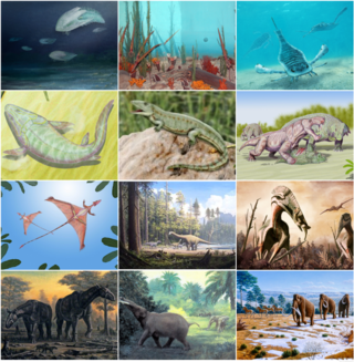
The Phanerozoic Eon is the current geologic eon in the geologic time scale, and the one during which abundant animal and plant life has existed. It covers 538.8 million years to the present, and it began with the Cambrian Period, when animals first developed hard shells preserved in the fossil record. The time before the Phanerozoic, called the Precambrian, is now divided into the Hadean, Archaean and Proterozoic eons.

In geology, a supercontinent is the assembly of most or all of Earth's continental blocks or cratons to form a single large landmass. However, some geologists use a different definition, "a grouping of formerly dispersed continents", which leaves room for interpretation and is easier to apply to Precambrian times. To separate supercontinents from other groupings, a limit has been proposed in which a continent must include at least about 75% of the continental crust then in existence in order to qualify as a supercontinent.

Laurasia was the more northern of two large landmasses that formed part of the Pangaea supercontinent from around 335 to 175 million years ago (Mya), the other being Gondwana. It separated from Gondwana 215 to 175 Mya during the breakup of Pangaea, drifting farther north after the split and finally broke apart with the opening of the North Atlantic Ocean c. 56 Mya. The name is a portmanteau of Laurentia and Asia.

The late Paleozoic icehouse, also known as the Late Paleozoic Ice Age (LPIA) and formerly known as the Karoo ice age, was an ice age that began in the Late Devonian and ended in the Late Permian, occurring from 360 to 255 million years ago (Mya), and large land-based ice-sheets were then present on Earth's surface. It was the second major icehouse period of the Phanerozoic. It is named after the tillite found in the Karoo Basin of western South Africa, where evidence for the ice age was first clearly identified in the 19th century.

The Karoo Supergroup is the most widespread stratigraphic unit in Africa south of the Kalahari Desert. The supergroup consists of a sequence of units, mostly of nonmarine origin, deposited between the Late Carboniferous and Early Jurassic, a period of about 120 million years.

The geology of Antarctica covers the geological development of the continent through the Archean, Proterozoic and Phanerozoic eons.

The geology of England is mainly sedimentary. The youngest rocks are in the south east around London, progressing in age in a north westerly direction. The Tees–Exe line marks the division between younger, softer and low-lying rocks in the south east and the generally older and harder rocks of the north and west which give rise to higher relief in those regions. The geology of England is recognisable in the landscape of its counties, the building materials of its towns and its regional extractive industries.

The geological history of Earth follows the major geological events in Earth's past based on the geological time scale, a system of chronological measurement based on the study of the planet's rock layers (stratigraphy). Earth formed about 4.54 billion years ago by accretion from the solar nebula, a disk-shaped mass of dust and gas left over from the formation of the Sun, which also created the rest of the Solar System.
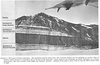
The Beacon Supergroup is a geological formation exposed in Antarctica and deposited from the Devonian to the Triassic. The unit was originally described as either a formation or sandstone, and upgraded to group and supergroup as time passed. It contains a sandy member known as the Beacon Heights Orthoquartzite.
The Glaciogenic Reservoir Analogue Studies Project (GRASP) is a research group studying the subglacial to proglacial record of Pleistocene glacial events. It is based in the Delft University of Technology.

Gondwana was a large landmass, often referred to as a supercontinent, that formed during the late Neoproterozoic and began to break up during the Jurassic period. The final stages of break-up, involving the separation of Antarctica from South America and Australia, occurred during the Paleogene. Gondwana was not considered a supercontinent by the earliest definition, since the landmasses of Baltica, Laurentia, and Siberia were separated from it. To differentiate it from the Indian region of the same name, it is also commonly called Gondwanaland.
Laurentia or the North American Craton is a large continental craton that forms the ancient geological core of North America. Many times in its past, Laurentia has been a separate continent, as it is now in the form of North America, although originally it also included the cratonic areas of Greenland and also the northwestern part of Scotland, known as the Hebridean Terrane. During other times in its past, Laurentia has been part of larger continents and supercontinents and itself consists of many smaller terranes assembled on a network of Early Proterozoic orogenic belts. Small microcontinents and oceanic islands collided with and sutured onto the ever-growing Laurentia, and together formed the stable Precambrian craton seen today.

Pangaea or Pangea was a supercontinent that existed during the late Paleozoic and early Mesozoic eras. It assembled from the earlier continental units of Gondwana, Euramerica and Siberia during the Carboniferous approximately 335 million years ago, and began to break apart about 200 million years ago, at the end of the Triassic and beginning of the Jurassic. In contrast to the present Earth and its distribution of continental mass, Pangaea was centred on the equator and surrounded by the superocean Panthalassa and the Paleo-Tethys and subsequent Tethys Oceans. Pangaea is the most recent supercontinent to have existed and the first to be reconstructed by geologists.
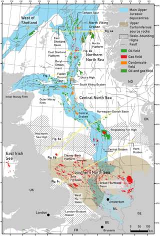
The geology of the North Sea describes the geological features such as channels, trenches, and ridges today and the geological history, plate tectonics, and geological events that created them.
A paleocontinent or palaeocontinent is a distinct area of continental crust that existed as a major landmass in the geological past. There have been many different landmasses throughout Earth's time. They range in sizes, some are just a collection of small microcontinents while others are large conglomerates of crust. As time progresses and sea levels rise and fall more crust can be exposed making way for larger landmasses. The continents of the past shaped the evolution of organisms on Earth and contributed to the climate of the globe as well. As landmasses break apart, species are separated and those that were once the same now have evolved to their new climate. The constant movement of these landmasses greatly determines the distribution of organisms on Earth's surface. This is evident with how similar fossils are found on completely separate continents. Also, as continents move, mountain building events (orogenies) occur, causing a shift in the global climate as new rock is exposed and then there is more exposed rock at higher elevations. This causes glacial ice expansion and an overall cooler global climate. Which effects the overall global climate trend of Earth. The movement of the continents greatly affects the overall dispersal of organisms throughout the world and the trend in climate throughout Earth's history. Examples include Laurentia, Baltica and Avalonia, which collided together during the Caledonian orogeny to form the Old Red Sandstone paleocontinent of Laurussia. Another example includes a collision that occurred during the late Pennsylvanian and early Permian time when there was a collision between the two continents of Tarimsky and Kirghiz-Kazakh. This collision was caused because of their askew convergence when the paleoceanic basin closed.

The Central Pangean Mountains were an extensive northeast–southwest trending mountain range in the central portion of the supercontinent Pangaea during the Carboniferous, Permian and Triassic periods. They were formed as a result of collision between the minor supercontinents Laurussia and Gondwana during the formation of Pangaea. At its greatest elevation during the early part of the Permian period, it was comparable to the present Himalayas. Remnants of this massive mountain range include the Appalachian Mountains and Ouachita Mountains of North America and the Little Atlas of Morocco, Africa.

The Dwyka Group is one of four geological groups that compose the Karoo Supergroup. It is the lowermost geological group and heralds the commencement of sedimentation of the Karoo Supergroup. Based on stratigraphic position, lithostratigraphic correlation and palynological analyses, these lowermost Karoo strata range between the Late Carboniferous (Pennsylvanian) to Early Permian in age.
The geology of Argentina includes ancient Precambrian basement rock affected by the Grenville orogeny, sediment filled basins from the Mesozoic and Cenozoic as well as newly uplifted areas in the Andes.
The Enticho Sandstone is a geological formation in north Ethiopia. It forms the lowermost sedimentary rock formation in the region and lies directly on the basement rocks. Enticho Sandstone consists of arenite that is rich in quartz. The formation has a maximum thickness of 200 metres. Locally, its upper part is coeval with the Edaga Arbi Glacials. The Enticho Sandstone has been deposited during the Ordovician, as evidenced by impressions of organisms.
219 Geology 31:977–980.