The Mariana Trench or Marianas Trench is located in the western Pacific Ocean approximately 200 kilometres (124 mi) east of the Mariana Islands, and has the deepest natural trench in the world. It is a crescent-shaped trough in the Earth's crust averaging about 2,550 km (1,580 mi) long and 69 km (43 mi) wide. The maximum known depth is 10,994 metres (36,070 ft) at the southern end of a small slot-shaped valley in its floor known as the Challenger Deep. However, some unrepeated measurements place the deepest portion at 11,034 metres (36,201 ft). For comparison: if Mount Everest were dropped into the trench at this point, its peak would still be over two kilometres (1.2 mi) under water.

A trench is a type of excavation or depression in the ground that is generally deeper than it is wide, and narrow compared with its length.

The Laramide orogeny was a period of mountain building in western North America, which started in the Late Cretaceous, 70 to 80 million years ago, and ended 35 to 55 million years ago. The exact duration and ages of beginning and end of the orogeny are in dispute. The Laramide orogeny occurred in a series of pulses, with quiescent phases intervening. The major feature that was created by this orogeny was deep-seated, thick-skinned deformation, with evidence of this orogeny found from Canada to northern Mexico, with the easternmost extent of the mountain-building represented by the Black Hills of South Dakota. The phenomenon is named for the Laramie Mountains of eastern Wyoming. The Laramide orogeny is sometimes confused with the Sevier orogeny, which partially overlapped in time and space.

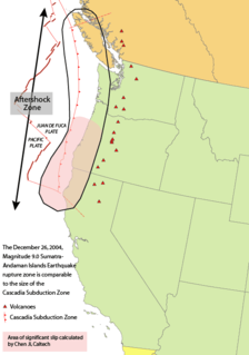
Convergent boundaries are areas on Earth where two or more lithospheric plates collide. One plate eventually slides beneath the other causing a process known as subduction. The subduction zone can be defined by a plane where many earthquakes occur, called the Benioff Zone. These collisions happen on scales of millions to tens of millions of years and can lead to volcanism, earthquakes, orogenesis, destruction of lithosphere, and deformation. Convergent boundaries occur between oceanic-oceanic lithosphere, oceanic-continental lithosphere, and continental-continental lithosphere. The geologic features related to convergent boundaries vary depending on crust types.

The Japan Trench is an oceanic trench part of the Pacific Ring of Fire off northeast Japan. It extends from the Kuril Islands to the northern end of the Izu Islands, and is 8,046 meters (26,398 ft) at its deepest. It links the Kuril-Kamchatka Trench to the north and the Izu-Ogasawara Trench to its south with a length of 800 km. This trench is created as the oceanic Pacific plate subducts beneath the continental Okhotsk Plate. The subduction process causes bending of the down going plate, creating a deep trench. Continuing movement on the subduction zone associated with the Japan Trench is one of the main causes of tsunamis and earthquakes in northern Japan, including the megathrust Tōhoku earthquake and resulting tsunami that occurred on 11 March 2011. The rate of subduction associated with the Japan Trench has been recorded at about 7.9-9.2 cm/yr.

The Farallon Plate was an ancient oceanic plate that began subducting under the west coast of the North American Plate—then located in modern Utah—as Pangaea broke apart during the Jurassic period. It is named for the Farallon Islands, which are located just west of San Francisco, California.

The Pacific Plate is an oceanic tectonic plate that lies beneath the Pacific Ocean. At 103 million square kilometres (40,000,000 sq mi), it is the largest tectonic plate.

A volcanic arc is a chain of volcanoes formed above a subducting plate,
positioned in an arc shape as seen from above. Offshore volcanoes form islands, resulting in a volcanic island arc. Generally, volcanic arcs result from the subduction of an oceanic tectonic plate under another tectonic plate, and often parallel an oceanic trench. The oceanic plate is saturated with water, and volatiles such as water drastically lower the melting point of the mantle. As the oceanic plate is subducted, it is subjected to greater and greater pressures with increasing depth. This pressure squeezes water out of the plate and introduces it to the mantle. Here the mantle melts and forms magma at depth under the overriding plate. The magma ascends to form an arc of volcanoes parallel to the subduction zone.

Marine geology or geological oceanography is the study of the history and structure of the ocean floor. It involves geophysical, geochemical, sedimentological and paleontological investigations of the ocean floor and coastal zone. Marine geology has strong ties to geophysics and to physical oceanography.

The Sunda Trench, earlier known as and sometimes still indicated as the Java Trench, is an oceanic trench located in the Indian Ocean near Sumatra, formed where the Australian-Capricorn plates subduct under a part of the Eurasian Plate. It is 3,200 kilometres (2,000 mi) long. Its maximum depth 7,725 metres (25,344 ft), is the deepest point in the Indian Ocean. The trench stretches from the Lesser Sunda Islands past Java, around the southern coast of Sumatra on to the Andaman Islands, and forms the boundary between Indo-Australian Plate and Eurasian plate. The trench is considered to be part of the Pacific Ring of Fire as well as one of a ring of oceanic trenches around the northern edges of the Australian Plate.

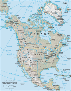
The North American Cordillera is the North American portion of the American Cordillera which is a mountain chain (cordillera) along the western side of the Americas. The North American Cordillera covers an extensive area of mountain ranges, intermontane basins, and plateaus in western North America, including much of the territory west of the Great Plains. It is also sometimes called the Western Cordillera, the Western Cordillera of North America, or the Pacific Cordillera.

The Slide Mountain Ocean was an ancient ocean that existed between the Intermontane Islands and North America beginning around 245 million years ago in the Triassic period. It is named after the Slide Mountain Terrane, which is composed of rocks from the ancient oceanic floor. There was a subduction zone on the Slide Mountain Ocean's floor called the Intermontane Trench where the Intermontane Plate was being subducted under North America. The floor of the Slide Mountain Ocean was pushed up onto the ancient margin of North America.

The Cassiar Mountains are the most northerly group of the Northern Interior Mountains in the Canadian province of British Columbia and also extend slightly into the southernmost Yukon Territory. They lie north and west of the Omineca Mountains, west of the northernmost Rockies and the Rocky Mountain Trench, north of the Hazelton Mountains and east of the Boundary Ranges. They form a section of the Continental Divide, that, in this region, separates water drainage between the Arctic and Pacific Oceans. Physiographically, they are a section of the larger Yukon-Tanana Uplands province, which in turn are part of the larger Intermontane Plateaus physiographic division.

The Insular Islands were a giant chain of active volcanic islands somewhere in the Pacific Ocean during the Cretaceous period that rode on top a microplate called the Insular Plate, beginning around 130 million years ago. The Insular Islands were surrounded by two prehistoric oceans, the Panthalassa Ocean to the west and the Bridge River Ocean to the east. About 115 million years ago, these islands collided with the North American continent, fusing onto the North American Plate and closing the Bridge River Ocean during the Mid-Cretaceous time.

The Intermontane Belt is a physiogeological region in the Pacific Northwest of North America, stretching from northern Washington into British Columbia, Yukon, and Alaska. It comprises rolling hills, high plateaus and deeply cut valleys. The rocks in the belt have very little similarities with the North American continent.


