
Atlantis is a fictional island mentioned within an allegory on the hubris of nations in Plato's works Timaeus and Critias, where it represents the antagonist naval power that besieges "Ancient Athens", the pseudo-historic embodiment of Plato's ideal state in The Republic. In the story, Athens repels the Atlantean attack unlike any other nation of the known world, supposedly giving testament to the superiority of Plato's concept of a state. The story concludes with Atlantis falling out of favor with the deities and submerging into the Atlantic Ocean.

In marine geology, a guyot, also known as a tablemount, is an isolated underwater volcanic mountain (seamount) with a flat top more than 200 m (660 ft) below the surface of the sea. The diameters of these flat summits can exceed 10 km (6.2 mi). Guyots are most commonly found in the Pacific Ocean, but they have been identified in all the oceans except the Arctic Ocean.

The Monteregian Hills is a linear chain of isolated hills in Montreal and Montérégie, between the Laurentians and the Appalachians.
Spartel Bank or Majuán Bank is a submerged former island located in the Strait of Gibraltar near Cape Spartel and the Spartel Sill. Its highest point is currently 56 metres below the surface. Spartel Bank is one of the several seamounts in the bed of Gibraltar Strait, similar but deeper seamounts are found at Camarinal Sill and further east. These represent landslide blocks which slid south from the north bank of the Strait of Gibraltar when the strait was formed, possibly through erosion by inflowing waters of the Zanclean flood.

Mont Saint-Grégoire is a mountain in the Montérégie region of southern Quebec, Canada. It is composed of essexite and syenite, strongly contrasting with the surrounding sedimentary rocks. The area around Mont Saint-Grégoire is known for its maple syrup production, as well as some wine production.
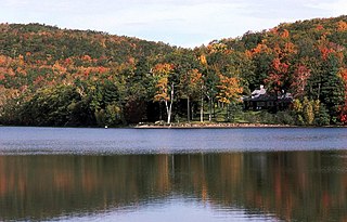
Mont Saint-Bruno is part of the Monteregian Hills in southern Quebec, Canada. Its summit stands 213 m (699 ft) high and lies 23 km (14 mi) east of downtown Montreal.

Mont Rougemont is part of the Monteregian Hills in southern Quebec. It is composed of igneous rock and hornfels. The summit stands 366 m (1,201 ft) above sea level. The mountain is mostly covered with sugar maple-dominated forest. Apple orchards and vineyards are cultivated on many of the lower slopes, and much of the fruit is used to make cider.

Mont Yamaska is part of the Monteregian Hills in southern Quebec. Its summit stands 411 m (1,348 ft) above sea level. This mountain is largely covered with deciduous forest dominated by sugar maple. Some apple orchards are raised on lower slopes.
The Lord Howe Seamount Chain is one of the two parallel seamount chains alongside the east coast of Australia; the Lord Howe and Tasmantid seamount chains both run north-south through parts of the Coral Sea and Tasman Sea. These chains have longitudes of approximately 159°E and 156°E respectively.

The New England Seamounts is a chain of over twenty underwater extinct volcanic mountains known as seamounts. This chain is located off the coast of Massachusetts in the Atlantic Ocean and extends over 1,000 km from the edge of Georges Bank. Many of the peaks of these mountains rise over 4,000 m from the seabed. The New England Seamounts chain is the longest such chain in the North Atlantic and is home to a diverse range of deep sea fauna. Scientists have visited the chain on various occasions to survey the geologic makeup and biota of the region. The chain is part of the Great Meteor hotspot track and was formed by the movement of the North American Plate over the New England hotspot. The oldest volcanoes that were formed by the same hotspot are northwest of Hudson Bay, Canada. Part of the seamount chain is protected by Northeast Canyons and Seamounts Marine National Monument.

The Bear Seamount is a guyot or flat-topped underwater volcano in the Atlantic Ocean. It is the oldest of the New England Seamounts, which was active more than 100 million years ago. It was formed when the North American Plate moved over the New England hotspot. It is located inside the Northeast Canyons and Seamounts Marine National Monument, which was proclaimed by President of the United States Barack Obama to protect the seamount's biodiversity.

The New England hotspot, also referred to as the Great Meteor hotspot, is a long-lived volcanic hotspot in the Atlantic Ocean. The hotspot's most recent eruptive center is the Great Meteor Seamount, and it probably created a short line of mid to late-Cenozoic age seamounts on the African Plate but appears to be currently inactive.

Mont Brome is part of the Monteregian Hills in southern Quebec. Its summit stands 553 m (1,814 ft) above sea level. It is near the town of Bromont, Quebec. The ski resort Ski Bromont lies on its slopes.

The Great Meteor Seamount, also called the Great Meteor Tablemount, is a guyot and the largest seamount in the North Atlantic with a volume of 24,000 km3 (5,800 cu mi). It is one of the Seewarte Seamounts, rooted on a large terrace located south of the Azores Plateau. The crust underlying Great Meteor has an age of 85 million years, deduced from the magnetic anomaly 34 (An34) at this location.
The Corner Rise Seamounts are a chain of extinct submarine volcanoes in the northern Atlantic Ocean east of the New England Seamounts. Both it and the New England Seamounts were formed when the North American Plate moved over the Great Meteor hotspot 75 million years ago. It is the shallowest seamount in New England, with some of its nineteen highest peaks only 800–900 m deep.

The Caloosahatchee Seamount is a seamount in the northern Atlantic Ocean. It is part of the Corner Rise Seamounts, which was active about 75 million years ago. It was formed when the North American Plate moved over the New England hotspot, also known as the Great Meteor Hotspot. The Great Meteor Hotspot also formed various kimberlite fields in Canada, the Monteregian Hills, the White Mountains, the New England Seamounts, and the Seewarte Seamounts, which are the newest volcanoes produced by the New England Hotspot.

The volcanology of Eastern Canada includes the hundreds of volcanic areas and extensive lava formations in Eastern Canada. The region's different volcano and lava types originate from different tectonic settings and types of volcanic eruptions, ranging from passive lava eruptions to violent explosive eruptions. Eastern Canada has very large volumes of magmatic rock called large igneous provinces. They are represented by deep-level plumbing systems consisting of giant dike swarms, sill provinces and layered intrusions. The most capable large igneous provinces in Eastern Canada are Archean age greenstone belts containing a rare volcanic rock called komatiite.
The Great Meteor hotspot track, also referred to as the New England hotspot track, is a vast trail of hotspot magmatism in the Northern Hemisphere. It extends over 5,800 km (3,604 mi) from Nunavut in Northern Canada to the northern Atlantic Ocean. Volcanism in the hotspot track was produced by the New England or Great Meteor hotspot, with the oldest magmatic activity dating back at least 214 million years ago during the Late Triassic period. This makes the Great Meteor track one of the oldest hotspot tracks on Earth. It contains over 80 volcanoes, with the most recognizable ones located in the Atlantic Ocean where they form seamounts.
Krylov Seamount is a volcanic seamount in the Atlantic Ocean, west of the Cape Verde islands. It is formed by one seamount and one ridge which are separated by a 5 kilometres (3.1 mi) wide depression, and it rises to a minimum depth of 1,240 metres (4,070 ft); formerly the depression was interpreted to be a caldera. The seamount probably formed no later than 70-75 million years ago before sinking to its current depth.
Madeira Abyssal Plain, also called Madeira Plain, is an abyssal plain situated at the center and deepest part of the Canary Basin. It is a north-northeast to south-southeast elongated basin that almost parallels the Mid-Atlantic Ridge. Its western boundary is marked by a chain of seamounts known as the either Seewarte Seamounts or Atlantis-Great Meteor Seamount Chain. Its eastern boundary is a distinct break of slope that marks the foot of the African Continental Rise. This abyssal plain occupies an area of about 68,000 km2 (26,000 sq mi). Across this basin, slope angles are generally less than 0.01°.
