
A fixed-point ocean observatory is an ocean observing autonomous system of automatic sensors and samplers that continuously gathers data from deep sea, water column and lower atmosphere, and transmits the data to shore in real or near real-time.
A fixed-point ocean observatory is an ocean observing autonomous system of automatic sensors and samplers that continuously gathers data from deep sea, water column and lower atmosphere, and transmits the data to shore in real or near real-time.
Fixed-point ocean observatories are typically composed of a cable anchored to the sea floor to which several automatic sensors and samplers are attached. The cable ends with a buoy at the ocean surface that may have some more sensors attached. [1] Most observatories have communicating buoys that transmit data to shore, and which allow changes to the acquisition method of the sensors, as required.
These unmanned platforms can be linked via a cable to the shore transmitting data via an internet connection, or they can transmit data to relay buoys which are able to provide a satellite link to the shore.
An example for a network of observatories is the Ocean Observatories Initiative.
A typical multi-disciplinary observatory is equipped with sensors and instruments to measure physical and biogeochemical variables along the water column. Additionally the surface buoy can hold several sensors measuring atmospheric parameters at sea level. [2] Main measured variables:
| Sea surface | Sea-surface temperature (SST) Sea-surface salinity (SSS) |
| Sub-surface | Temperature Salinity |
| Atmosphere (Surface) | Air Temperature |
In order to do so, typically the ocean observatories are equipped with instruments like:
Ocean observatories can collect data for different purposes from scientific research to environmental monitoring for marine operations or governance for the benefit of economy and society as a whole. Ocean observatories provide real-time, or near real time data allowing to detect changes as they happen, such as geo-hazards for example. Furthermore continuous time series data allow to investigate interannual-to-decadal changes and to capture episodic events, changes in ocean circulation, water properties, water mass formation and ecosystems, to quantify air-sea fluxes, and to analyse the role of the oceans for the climate.[ citation needed ]
The data collected by the several ocean observatories around the globe on the sub-sea-floor, seafloor, and water column, allows to improve our knowledge [3] of the ocean including:
Moreover networks of ocean observatories can also be used to input data into global ocean models and to calibrate them thus allowing for the investigation of future changes in ocean circulation and ecosystems.

Bathymetry is the study of underwater depth of ocean floors, lake floors, or river floors. In other words, bathymetry is the underwater equivalent to hypsometry or topography. The first recorded evidence of water depth measurements are from Ancient Egypt over 3000 years ago.
The Arctic Research Office (ARO) a division of the National Oceanic and Atmospheric Administration (NOAA) run under the auspices of the Office of Oceanic and Atmospheric Research (OAR).
An acoustic doppler current profiler (ADCP) is a hydroacoustic current meter similar to a sonar, used to measure water current velocities over a depth range using the Doppler effect of sound waves scattered back from particles within the water column. The term ADCP is a generic term for all acoustic current profilers, although the abbreviation originates from an instrument series introduced by RD Instruments in the 1980s. The working frequencies range of ADCPs range from 38 kHz to several megahertz.

The National Data Buoy Center (NDBC) is a part of the National Oceanic and Atmospheric Administration's (NOAA) National Weather Service (NWS). NDBC designs, develops, operates, and maintains a network of data collecting buoys and coastal stations. The NDBC is located in southern Mississippi as a tenant at the John C. Stennis Space Center, a National Aeronautics and Space Administration (NASA) facility.

The former Proudman Oceanographic Laboratory (POL) is based in Brownlow Street, Liverpool, England. In April 2010, POL merged with the National Oceanography Centre, Southampton (NOCS) to form the National Oceanography Centre. The Liverpool laboratory's scientific research focuses on oceanography encompassing global sea-levels and geodesy, numerical modelling of continental shelf seas and coastal sediment processes. This research alongside activities of surveying, monitoring, data management and forecasting provides strategic support for the wider mission of the Natural Environment Research Council.
VENUS - is one of two principal cabled seafloor observatories operated by Ocean Networks Canada at the University of Victoria, British Columbia, Canada.
A mooring in oceanography is a collection of devices connected to a wire and anchored on the sea floor. It is the Eulerian way of measuring ocean currents, since a mooring is stationary at a fixed location. In contrast to that, the Lagrangian way measures the motion of an oceanographic drifter, the Lagrangian drifter.

The Ocean Observatories Initiative (OOI) is a National Science Foundation (NSF) Major Research Facility composed of a network of science-driven ocean observing platforms and sensors in the Atlantic and Pacific Oceans. This networked infrastructure measures physical, chemical, geological, and biological variables from the seafloor to the sea surface and overlying atmosphere, providing an integrated data collection system on coastal, regional and global scales. OOI's goal is to deliver data and data products for a 25-year-plus time period, enabling a better understanding of ocean environments and critical ocean issues.

A drifter is an oceanographic device floating on the surface to investigate ocean currents by tracking location. They can also measure other parameters like sea surface temperature, salinity, barometric pressure, and wave height. Modern drifters are typically tracked by satellite, often GPS. They are sometimes called Lagrangian drifters since the location of the measurements they make moves with the flow. A major user of drifters is NOAA's Global Drifter Program.
The following are considered ocean essential climate variables (ECVs) by the Ocean Observations Panel for Climate (OOPC) that are currently feasible with current observational systems.
The Hawaii Ocean Time-series (HOT) program is a long-term oceanographic study based at the University of Hawaii at Manoa. In 2015, the American Society for Microbiology designated the HOT Program's field site Station ALOHA a "Milestone in Microbiology", for playing "a key role in defining the discipline of microbial oceanography and educating the public about the vital role of marine microbes in global ecosystems."

CTD stands for conductivity, temperature, and depth. A CTD instrument is an oceanography sonde used to measure the electrical conductivity, temperature, and pressure of seawater. The pressure is closely related to depth. Conductivity is used to determine salinity.

A cabled observatory is a seabed oceanographic research platform connected to land by cables that provide power and communication. Observatories are outfitted with a multitude of scientific instruments that can collect many kinds of data from the seafloor and water column. By removing the limitations of undersea power sources and sonar or RF communications, cabled observatories allow persistent study of underwater phenomena. Data from these instruments is relayed to a land station and data networks, such as Ocean Networks Canada, in real time.
The Tropical Atmosphere Ocean (TAO) project is a major international effort that instrumented the entire tropical Pacific Ocean, with approximately 70 deep ocean moorings. The development of the TAO array in 1985 was motivated by the 1982-1983 El Niño event and ultimately designed for the study of year-to-year climate variations related to El Niño and the Southern Oscillation (ENSO). Led by the TAO Project Office of the Pacific Marine Environmental Laboratory (PMEL), the full array of 70 moorings was completed in 1994.
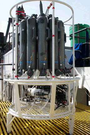
A rosette sampler is a device used for water sampling in deep water. Rosette samplers are used in the ocean and large inland water bodies such as the North American Great Lakes in order to investigate quality. Rosette samplers are a key piece of equipment in oceanography and have been used to collect information over many years in repeat hydrographic surveys.

A float is an oceanographic instrument platform used for making subsurface measurements in the ocean without the need for a ship, propeller, or a person operating it. Floats measure the physical and chemical aspects of the ocean in detail, such as measuring the direction and speed of water or the temperature and salinity. A float will descend to a predetermined depth where it will be neutrally buoyant. Once a certain amount of time has passed, most floats will rise back to the surface by increasing its buoyancy so it can transmit the data it collected to a satellite. A float can collect data while it is neutrally buoyant or moving through the water column. Often, floats are treated as disposable, as the expense of recovering them from remote areas of the ocean is prohibitive; when the batteries fail, a float ceases to function, and drifts at depth until it runs aground or floods and sinks. In other cases, floats are deployed for a short time and recovered.
Free Ocean CO2 Enrichment (FOCE) is a technology facilitating studies of the consequences of ocean acidification for marine organisms and communities by enabling the precise control of CO2 enrichment within in situ, partially open, experimental enclosures. Current FOCE systems control experimental CO2 perturbations by real-time monitoring of differences in seawater pH between treatment (i.e. high-CO2) and control (i.e. ambient) seawater within experimental enclosures.
European Multidisciplinary Seafloor and water-column Observatory (EMSO) is a large-scale European distributed Research Infrastructure for ocean observation, enabling real-time interactive long term monitoring of ocean processes. EMSO allows study of the interaction between the geosphere, the biosphere, the hydrosphere, and the lithosphere; including natural hazards, climate change, and marine ecosystems. EMSO nodes have been deployed at key sites in European seas, starting from the Arctic, through the Atlantic and Mediterranean, to the Black Sea.
Ocean Networks Canada is a world-leading research and ocean observing facility hosted and owned by the University of Victoria, and managed by the not-for profit ONC Society. ONC operates unparalleled observatories in the deep ocean and coastal waters of Canada’s three coasts–the Arctic, the Pacific and the Atlantic–gathering biological, chemical, geological and physical data to drive solutions for science, industry and society. ONC operates the NEPTUNE and VENUS cabled ocean observatories in the northeast Pacific Ocean and the Salish Sea. Additionally, Ocean Networks Canada operates smaller community-based observatories offshore from Cambridge Bay, Nunavut., Campbell River, Kitamaat Village and Digby Island. These observatories collect data on physical, chemical, biological, and geological aspects of the ocean over long time periods. As with other ocean observatories such as ESONET, Ocean Observatories Initiative, MACHO and DONET, scientific instruments connected to Ocean Networks Canada are operated remotely and provide continuous streams of freely available data to researchers and the public. Over 200 gigabytes of data are collected every day.

The National Science Foundation's (NSF) Ocean Observatories Initiative (OOI) Regional Scale Nodes (RSN) component is an electro-optically cabled underwater observatory that directly connects to the global Internet. It is the largest cable-linked seabed observatory in the world, and also the first of its kind in the United States.