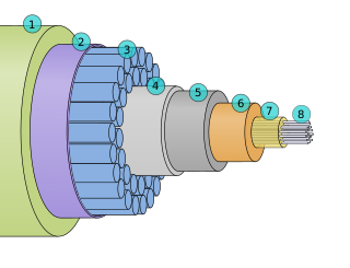
A submarine communications cable is a cable laid on the seabed between land-based stations to carry telecommunication signals across stretches of ocean and sea. The first submarine communications cables were laid beginning in the 1850s and carried telegraphy traffic, establishing the first instant telecommunications links between continents, such as the first transatlantic telegraph cable which became operational on 16 August 1858.

A cable television headend is a master facility for receiving television signals for processing and distribution over a cable television system. A headend facility may be staffed or unstaffed and is typically surrounded by some type of security fencing. The building is typically sturdy and purpose-built to provide security, cooling, and easy access for the electronic equipment used to receive and re-transmit video over the local cable infrastructure. One can also find head ends in power-line communication (PLC) substations and Internet communications networks.
Sound Surveillance System (SOSUS) was the original name for a submarine detection system based on passive sonar developed by the United States Navy to track Soviet submarines. The system's true nature was classified with the name and acronym SOSUS classified as well. The unclassified name Project Caesar was used to cover the installation of the system and a cover story developed regarding the shore stations, identified only as a Naval Facility (NAVFAC), being for oceanographic research. The name changed to Integrated Undersea Surveillance System (IUSS) in 1985, as the fixed bottom arrays were supplemented by the mobile Surveillance Towed Array Sensor System (SURTASS) and other new systems. The commands and personnel were covered by the "oceanographic" term until 1991 when the mission was declassified. As a result, the commands, Oceanographic System Atlantic and Oceanographic System Pacific became Undersea Surveillance Atlantic and Undersea Surveillance Pacific, and personnel were able to wear insignia reflecting the mission.
Fibre-optic Link Around the Globe (FLAG) is a 28,000-kilometre-long fibre optic mostly-submarine communications cable that connects the United Kingdom, Japan, India, and many places in between. The cable is operated by Global Cloud Xchange, a subsidiary of RCOM. The system runs from the eastern coast of North America to Japan. Its Europe–Asia segment was the fourth longest cable in the world in 2008.

Fiber to the x or fiber in the loop is a generic term for any broadband network architecture using optical fiber to provide all or part of the local loop used for last mile telecommunications. As fiber optic cables are able to carry much more data than copper cables, especially over long distances, copper telephone networks built in the 20th century are being replaced by fiber.
VENUS - is one of two principal cabled seafloor observatories operated by Ocean Networks Canada at the University of Victoria, British Columbia, Canada.
Unity is a Trans-Pacific submarine communications cable between Japan and the United States that was completed in April 2010.

The Ocean Observatories Initiative (OOI) is a National Science Foundation (NSF) Major Research Facility composed of a network of science-driven ocean observing platforms and sensors in the Atlantic and Pacific Oceans. This networked infrastructure measures physical, chemical, geological, and biological variables from the seafloor to the sea surface and overlying atmosphere, providing an integrated data collection system on coastal, regional and global scales. OOI's goal is to deliver data and data products for a 25-year-plus time period, enabling a better understanding of ocean environments and critical ocean issues.
Monterey Accelerated Research System (MARS) is a cabled-based observatory system below the surface of Monterey Bay, developed and managed by the Monterey Bay Aquarium Research Institute. The system, operational since November 10, 2008, incorporates a 52 km (32 mi) undersea cable that carries data and power to benthic instrument nodes, AUVs, and various benthic and moored instrumentation.
Communication services in American Samoa are diversified among telephony, radio broadcasting, television, and Internet services.
The following are considered ocean essential climate variables (ECVs) by the Ocean Observations Panel for Climate (OOPC) that are currently feasible with current observational systems.
TRANSPAC or Trans-pacific cable (TPC) is a series of undersea cables under the Pacific Ocean.
SAex is a proposed submarine communications cable linking South Africa to the United States with branches to Namibia, Saint Helena, and Brazil.

A cabled observatory is a seabed oceanographic research platform connected to land by cables that provide power and communication. Observatories are outfitted with a multitude of scientific instruments that can collect many kinds of data from the seafloor and water column. By removing the limitations of undersea power sources and sonar or RF communications, cabled observatories allow persistent study of underwater phenomena. Data from these instruments is relayed to a land station and data networks, such as Ocean Networks Canada, in real time.
European Multidisciplinary Seafloor and water-column Observatory (EMSO) is a large-scale European distributed Research Infrastructure for ocean observation, enabling real-time interactive long term monitoring of ocean processes. EMSO allows study of the interaction between the geosphere, the biosphere, the hydrosphere, and the lithosphere; including natural hazards, climate change, and marine ecosystems. EMSO nodes have been deployed at key sites in European seas, starting from the Arctic, through the Atlantic and Mediterranean, to the Black Sea.
Ocean Networks Canada is a world-leading research and ocean observing facility hosted and owned by the University of Victoria, and managed by the not-for profit ONC Society. ONC operates unparalleled observatories in the deep ocean and coastal waters of Canada’s three coasts–the Arctic, the Pacific and the Atlantic–gathering biological, chemical, geological and physical data to drive solutions for science, industry and society. ONC operates the NEPTUNE and VENUS cabled ocean observatories in the northeast Pacific Ocean and the Salish Sea. Additionally, Ocean Networks Canada operates smaller community-based observatories offshore from Cambridge Bay, Nunavut., Campbell River, Kitamaat Village and Digby Island. These observatories collect data on physical, chemical, biological, and geological aspects of the ocean over long time periods. As with other ocean observatories such as ESONET, Ocean Observatories Initiative, MACHO and DONET, scientific instruments connected to Ocean Networks Canada are operated remotely and provide continuous streams of freely available data to researchers and the public. Over 200 gigabytes of data are collected every day.

JASCO Applied Sciences provides scientific consulting services and equipment related to underwater acoustics. JASCO operates from 7 international locations and provides services to the oil and gas, marine construction, energy, renewable energy, fisheries, maritime transport and defence sectors. The head office is located in Halifax, NS Canada. JASCO employs acousticians, bioacousticians, physicists, marine mammal scientists, engineers, technologists, and project managers.

The National Science Foundation's (NSF) Ocean Observatories Initiative (OOI) Regional Scale Nodes (RSN) component is an electro-optically cabled underwater observatory that directly connects to the global Internet. It is the largest cable-linked seabed observatory in the world, and also the first of its kind in the United States.

A fixed-point ocean observatory is an ocean observing autonomous system of automatic sensors and samplers that continuously gathers data from deep sea, water column and lower atmosphere, and transmits the data to shore in real or near real-time.
The following outline is provided as an overview of and topical guide to infrastructure of the U.S. state of Washington.
