
The Macdonald hotspot is a volcanic hotspot in the southern Pacific Ocean. The hotspot was responsible for the formation of the Macdonald Seamount, and possibly the Austral-Cook Islands chain. It probably did not generate all of the volcanism in the Austral and Cook Islands as age data imply that several additional hotspots were needed to generate some volcanoes.
The Mid-Pacific Mountains (MPM) is a large oceanic plateau located in the central North Pacific Ocean or south of the Hawaiian–Emperor seamount chain. Of volcanic origin and Mesozoic in age, it is located on the oldest part of the Pacific Plate and rises up to 2 km (1.2 mi) above the surrounding ocean floor and is covered with several layers of thick sedimentary sequences that differ from those of other plateaux in the North Pacific. About 50 seamounts are distributed over the MPM. Some of the highest points in the range are above sea level which include Wake Island and Marcus Island.

Arago hotspot is a hotspot in the Pacific Ocean, presently located below the Arago seamount close to the island of Rurutu, French Polynesia.

Wōdejebato is a Cretaceous guyot or tablemount in the northern Marshall Islands, Pacific Ocean. Wōdejebato is probably a shield volcano and is connected through a submarine ridge to the smaller Pikinni Atoll 74 kilometres (46 mi) southeast of the guyot; unlike Wōdejebato, Pikinni rises above sea level. The seamount rises for 4,420 metres (14,500 ft) to 1,335 metres (4,380 ft) depth and is formed by basaltic rocks. The name Wōdejebato refers to a sea god of Pikinni.

Limalok is a Cretaceous-Paleocene guyot/tablemount in the southeastern Marshall Islands, one of a number of seamounts in the Pacific Ocean. It was probably formed by a volcanic hotspot in present-day French Polynesia. Limalok lies southeast of Mili Atoll and Knox Atoll, which rise above sea level, and is joined to each of them through a volcanic ridge. It is located at a depth of 1,255 metres (4,117 ft) and has a summit platform with an area of 636 square kilometres (246 sq mi).
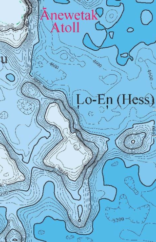
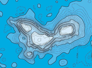
Lo-En or Hess is an Albian–Campanian guyot in the Marshall Islands. One among a number of seamounts in the Pacific Ocean, it was probably formed by a hotspot in what is present-day French Polynesia. Lo-En lies southeast of Eniwetok which rises above sea level, and Lo-En is almost connected to it through a ridge.

Ruwitūn̄tūn̄ is a guyot in the Pacific Ocean which reaches a depth of 1,215 metres (3,986 ft) below sea level. It is capped off with a summit platform covered in sediments and some volcanic pinnacles with craters. Basaltic rocks have been found on Ruwitūn̄tūn̄.
MIT Guyot is a guyot in the Pacific Ocean that rises to a depth of 1,323 metres (4,341 ft). It has a 20-kilometre-long (12 mi) summit platform and formed during the Cretaceous in the region of present-day French Polynesia through volcanic eruptions.
Takuyo-Daisan is a guyot in the Western Pacific Ocean off Japan. It is 1,409 metres (4,623 ft) deep and has a square-shaped flat top surrounded by a perimeter ridge. Several other seamounts lie nearby.
Ioah Guyot is a seamount in the Pacific Ocean, close to the Marshall Islands. Part of the Magellan Seamounts, it is a shield volcano that has erupted alkali basalt and hawaiite 87 million years ago, but may have continued erupting into the Miocene. During the Cretaceous, reefs developed on the guyot.

Ita Mai Tai is a Cretaceous-early Cenozoic seamount northwest of the Marshall Islands and north of Micronesia. One among a number of seamounts in the Pacific Ocean, it is part of the Magellan Seamounts which may have a hotspot origin although Ita Mai Tai itself may not have formed on a hotspot.
The Rarotonga hotspot is a volcanic hotspot in the southern Pacific Ocean. The hotspot is claimed to be responsible for the formation of Rarotonga and some volcanics of Aitutaki but an alternative explanation for these islands most recent volcanics has not be ruled out. Recently alternatives to hotspot activity have been offered for several other intra-plate volcanoes that may have been associated with the Rarotonga hotspot hypothesis.

Resolution Guyot is a guyot (tablemount) in the underwater Mid-Pacific Mountains in the Pacific Ocean. It is a circular flat mountain, rising 500 metres (1,600 ft) above the seafloor to a depth of about 1,320 metres (4,330 ft), with a 35-kilometre-wide (22 mi) summit platform. The Mid-Pacific Mountains lie west of Hawaii and northeast of the Marshall Islands, but at the time of its formation, the guyot was located in the Southern Hemisphere.

Horizon Guyot is a presumably Cretaceous guyot (tablemount) in the Mid-Pacific Mountains, Pacific Ocean. It is an elongated ridge, over 300 kilometres (190 mi) long and 4.3 kilometres (2.7 mi) high, that stretches in a northeast-southwest direction and has two flat tops; it rises to a minimum depth of 1,443 metres (4,730 ft). The Mid-Pacific Mountains lie west of Hawaii and northeast of the Line Islands.
Allison Guyot is a tablemount (guyot) in the underwater Mid-Pacific Mountains of the Pacific Ocean. It is a trapezoidal flat mountain rising 1,500 metres above the seafloor to a depth of less than 1,500 m, with a summit platform 35 by 70 kilometres wide. The Mid-Pacific Mountains lie west of Hawaii and northeast of the Marshall Islands, but at the time of their formation were located in the Southern Hemisphere.
Darwin Guyot is a volcanic underwater mountain top, or guyot, in the Mid-Pacific Mountains between the Marshall Islands and Hawaii. Named after Charles Darwin, it rose above sea level more than 118 million years ago during the early Cretaceous period to become an atoll, developed rudist reefs, and then drowned, perhaps as a consequence of sea level rise. The flat top of Darwin Guyot now rests 1,266 metres (4,154 ft) below sea level.
Vlinder Guyot is a guyot in the Western Pacific Ocean. It rises to a depth of 1,500 metres (4,900 ft) and has a flat top covering an area of 40 by 50 kilometres. On top of this flat top lie some volcanic cones, one of which rises to a depth of 551 metres (1,808 ft) below sea level. Vlinder Guyot has noticeable rift zones, including an older and lower volcano to the northwest and Oma Vlinder seamount south.
Daiichi-Kashima Seamount is a guyot in the Pacific Ocean off Japan. It is about 3.5 kilometres (2.2 mi) high and reaches a depth of 3,540 metres (11,610 ft). Daiichi-Kashima formed during the Barremian as a result of volcanic activity; during the Albian reefs formed on the seamount and generated a limestone cap. The seamount later.
Cape Johnson Guyot is a guyot in the Pacific Ocean, more precisely in the Mid-Pacific Mountains, and the type locality of guyots. It is of middle Cretaceous age and a number of fossils have been dredged from it.

