Bear Seamount

Last updated

Bear Seamount
Bear Seamount guyot.jpg
3-D depiction of Bear Seamount, with Physalia Seamount in the background.
NE seamounts.jpg
North Atlantic Ocean, about 200 miles (320 km) from Woods Hole, Massachusetts [1]
Summit depth1,100 m (3,600 ft) [1]
Height2,000 m (6,600 ft)
Location
LocationNorth Atlantic Ocean, about 200 miles (320 km) from Woods Hole, Massachusetts [1]
Coordinates 39°55′N67°24′W / 39.917°N 67.400°W / 39.917; -67.400 Coordinates: 39°55′N67°24′W / 39.917°N 67.400°W / 39.917; -67.400 [2]
Geology
Type Guyot
Volcanic arc/chain New England Seamounts
Age of rock 100–103 million years [3]
Bathymetric image of Bear Seamount Bear Seamount.jpg
Bathymetric image of Bear Seamount

The Bear Seamount is a guyot or flat-topped underwater volcano in the Atlantic Ocean. It is the oldest of the New England Seamounts, which was active more than 100 million years ago. It was formed when the North American Plate moved over the New England hotspot. [3] It is located inside the Northeast Canyons and Seamounts Marine National Monument, which was proclaimed by President of the United States Barack Obama to protect the seamount's biodiversity. [4]

Contents

Formation

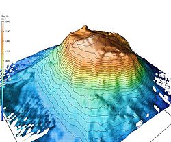
The Bear Seamount is the first guyot in a chain of about 30 extinct volcanoes extending in a straight line south-eastwards from the edge of the continental shelf near Woods Hole, Massachusetts to north-east of Bermuda. These seamounts resulted from the movement of a mantle plume hotspot. This hotspot is now under the Great Meteor Seamount. The chain rises about 4,000 metres (13,000 ft) above the surrounding Sohm Abyssal Plain. Over time they have been eroded and have developed flat table-like summits surrounded by slopes with an inclination of about 20°. The currents in the vicinity of the Bear Seamount include the warm water Gulf Stream flowing towards the north east, the deep boundary current flowing along the continental shelf towards the south west, and the deep, icy cold Arctic bottom water that flows past the lower flanks of the chain. [5]

Bear Seamount rises approximately 2,000 to 3,000 metres (6,600 to 9,800 ft) above the surrounding seabed and the roughly flat summit is about 1,100 metres (3,600 ft) below the surface of the sea. The top is covered by a deep layer of sediment through which basaltic rocks and erratic boulders protrude. Much of this material has fallen from above, probably from icebergs that drifted southwards during the Pleistocene. [5]

Biodiversity

Because little was known about the biodiversity of the New England Seamount Chain, an expedition was mounted in 2000. The NOAA National Marine Fisheries Service deep water research vessel R/V Delaware II made 20 exploratory trawls in the vicinity of Bear Seamount and around 274 species were collected. These included 115 species of fish, some of which were rare or had not been recorded in the western North Atlantic before. The roundnose grenadier ( Coryphaenoides rupestris ) and the onion-eye grenadier ( Macrourus berglax ) were the only fish species of potential commercial importance – they were caught in mid-water at depths of between 1,100 and 1,800 metres (3,600 and 5,900 ft) and were up to a metre in length. [5] A common but much smaller fish was Aldrovandia phalacra . [5]

Twenty-six species of cephalopods were collected including squid such as Mastigoteuthis agassizii and Mastigoteuthis magna . Other invertebrates caught by trawls dragged along the seamount surface included 46 species of crustacean such as the prawns Sergestes spp. and Acanthephyra spp., and the shrimp Pasiphaea spp. Also present was the bank-forming deepwater coral Lophelia pertusa , which supported a community of worms, hydroids and other corals. Brittle stars, especially Ophiomusium lymani , were numerous as were the sea urchin Echinus affinis , the sea star Neomorphaster forcipatus , mysids and various scyphozoans. [5]

Notes and references

  1. 1 2 3 "NOAA Ocean Explorer" . Retrieved August 13, 2007.
  2. "Alvin Dive Information". Archived from the original on September 8, 2006. Retrieved August 13, 2007.
  3. 1 2 "Geological Origin of the New England Seamount Chain". National Oceanic and Atmospheric Administration. U.S. Department of Commerce. 2005. Retrieved September 16, 2007.
  4. "Secretaries Pritzker, Jewell Applaud President's Designation of Northeast Canyons and Seamounts Marine National Monument". U.S. Department of the Interior . September 15, 2016.
  5. 1 2 3 4 5 Moore, J.A.; Vecchione, M.; Collette, B. B.; Gibbons, R.; Hartel, K. E.; Galbraithe, J. K.; Turnipseed, M.; Southworth, M.; Watkins, E. (2003). "Biodiversity of Bear Seamount, New England Seamount Chain: Results of exploratory trawling" (PDF). Journal of Northwest Atlantic Fishery Science. 31: 363–372. doi:10.2960/J.v31.a28. Archived from the original (PDF) on December 3, 2013.

Related Research Articles

Guyot Isolated, flat-topped underwater volcano mountain

In marine geology, a guyot, also known as a tablemount, is an isolated underwater volcanic mountain (seamount) with a flat top more than 200 m (660 ft) below the surface of the sea. The diameters of these flat summits can exceed 10 km (6.2 mi). Guyots are most commonly found in the Pacific Ocean, but they have been identified in all the oceans except the Arctic Ocean.

Seamount Mountain rising from the ocean seafloor that does not reach to the waters surface

A seamount is a large geologic landform that rises from the ocean floor that does not reach to the water's surface, and thus is not an island, islet or cliff-rock. Seamounts are typically formed from extinct volcanoes that rise abruptly and are usually found rising from the seafloor to 1,000–4,000 m (3,300–13,100 ft) in height. They are defined by oceanographers as independent features that rise to at least 1,000 m (3,281 ft) above the seafloor, characteristically of conical form. The peaks are often found hundreds to thousands of meters below the surface, and are therefore considered to be within the deep sea. During their evolution over geologic time, the largest seamounts may reach the sea surface where wave action erodes the summit to form a flat surface. After they have subsided and sunk below the sea surface such flat-top seamounts are called "guyots" or "tablemounts".

Bottom trawling Fishing method for fishing trawlers

Bottom trawling is trawling along the seafloor. It is also referred to as "dragging". The scientific community divides bottom trawling into benthic trawling and demersal trawling. Benthic trawling is towing a net at the very bottom of the ocean and demersal trawling is towing a net just above the benthic zone. Bottom trawling can be contrasted with midwater trawling, where a net is towed higher in the water column. Midwater trawling catches pelagic fish such as anchovies and mackerel, whereas bottom trawling targets both bottom-living fish (groundfish) and semi-pelagic species such as cod, squid, shrimp, and rockfish.

High island Island of volcanic origin

Geologically, a high island or volcanic island is an island of volcanic origin. The term can be used to distinguish such islands from low islands, which are formed from sedimentation or the uplifting of coral reefs.

Neocyema erythrosoma is a species of pelagic fish, a deep-water bobtail snipe eel in the family Cyematidae. It is the only member of its genus, Neocyema. It was first described by Peter Castle in 1978 after two specimens were caught at great depths in the south Atlantic Ocean in 1971. Further specimens have since been caught in the North Atlantic.

New England Seamounts Chain of more than 20 seamounts in the Atlantic Ocean

The New England Seamounts is a chain of over twenty underwater extinct volcanic mountains known as seamounts. This chain is located off the coast of Massachusetts in the Atlantic Ocean and extends over 1,000 km from the edge of Georges Bank. Many of the peaks of these mountains rise over 4,000 m from the seabed. The New England Seamounts chain is the longest such chain in the North Atlantic and is home to a diverse range of deep sea fauna. Scientists have visited the chain on various occasions to survey the geologic makeup and biota of the region. The chain is part of the Great Meteor hotspot track and was formed by the movement of the North American Plate over the New England hotspot. The oldest volcanoes that were formed by the same hotspot are northwest of Hudson Bay, Canada. Part of the seamount chain is protected by Northeast Canyons and Seamounts Marine National Monument.

Cobb Seamount is a seamount and guyot located 500 km (310 mi) west of Grays Harbor, Washington, United States. Cobb Seamount is one of the seamounts in the Cobb–Eickelberg Seamount chain, a chain of underwater volcanoes created by the Cobb hotspot that terminates near the coast of Alaska. It lies just west of the Cascadia subduction zone, and was discovered in August 1950 by the U.S. Fish and Wildlife Service fisheries research vessel R/V John N. Cobb. By 1967, over 927 km (576 mi) of soundings and dozens of samples from the seamount had been collected.

Great Meteor Seamount A large guyot in the Southern Azores Seamount Chain

The Great Meteor Seamount, also called the Great Meteor Tablemount, is a guyot and the largest seamount in the North Atlantic with a volume of 24,000 km3 (5,800 cu mi). It is one of the Seewarte Seamounts, rooted on a large terrace located south of the Azores Plateau. The crust underlying Great Meteor has an age of 85 million years, deduced from the magnetic anomaly 34 (An34) at this location.

Anton Dohrn Seamount Guyot in the Rockall Trough in the northeast Atlantic

The Anton Dohrn Seamount is a guyot in the Rockall Trough in the northeast Atlantic. It is 1.8 kilometres (1.1 mi) high and is topped with pinnacles, one of which reaches a depth of 530 metres (1,740 ft). Away from the flat top upon which the pinnacles rest, the slopes fall off steeply into the Rockall Trough and a moat in the sediment that surrounds the seamount.

The following outline is provided as an overview of and introduction to Oceanography.

Deep-water coral

The habitat of deep-water corals, also known as cold-water corals, extends to deeper, darker parts of the oceans than tropical corals, ranging from near the surface to the abyss, beyond 2,000 metres (6,600 ft) where water temperatures may be as cold as 4 °C (39 °F). Deep-water corals belong to the Phylum Cnidaria and are most often stony corals, but also include black and thorny corals and soft corals including the Gorgonians. Like tropical corals, they provide habitat to other species, but deep-water corals do not require zooxanthellae to survive.

The Fogo Seamounts, also called the Fogo Seamount Chain, are a group of undersea mountains southeast of the Grand Banks of Newfoundland in the North Atlantic Ocean. This seamount chain, lying approximately 500 km (310 mi) offshore from the island of Newfoundland, consists of several submarine volcanoes that have been extinct for millions of years. They are one of the few seamount chains located in Canadian waters off the coast of Atlantic Canada.

Corner Rise Seamounts Chain of extinct submarine volcanoes in the northern Atlantic Ocean

The Corner Rise Seamounts are a chain of extinct submarine volcanoes in the northern Atlantic Ocean east of the New England Seamounts. Both it and the New England Seamounts were formed when the North American Plate moved over the Great Meteor hotspot 75 million years ago. It is the shallowest seamount in New England, with some of its nineteen highest peaks only 800–900 m deep.

Aldrovandia phalacra, the Hawaiian halosaurid, is a species of ray-finned fish in the family Halosauridae. It is a circumglobal species found at bathyal depths.

<i>Coryphaenoides rupestris</i> Species of fish

Coryphaenoides rupestris is a species of marine ray-finned fish in the family Macrouridae. Its common names include the rock grenadier, the roundnose grenadier and the roundhead rat-tail. In France it is known as grenadier de roche and in Spain as granadero de roca. It is a large, deep-water species and is fished commercially in the northern Atlantic Ocean.

<i>Macrourus berglax</i> Species of fish

Macrourus berglax, the roughhead grenadier or onion-eye grenadier, is a species of marine ray-finned fish in the family Macrouridae. It is a deep-water fish found in the Atlantic Ocean.

Bassogigas gillii is a species of cusk-eel found in the Indian, Pacific Ocean, and Atlantic Oceans at depths of from 637 to 2,239 metres.

Ita Mai Tai

Ita Mai Tai is a Cretaceous-early Cenozoic seamount northwest of the Marshall Islands and north of Micronesia. One among a number of seamounts in the Pacific Ocean, it is part of the Magellan Seamounts which may have a hotspot origin although Ita Mai Tai itself may not have formed on a hotspot.

Horizon Guyot Tablemount in the Pacific Ocean

Horizon Guyot is a presumably Cretaceous guyot (tablemount) in the Mid-Pacific Mountains, Pacific Ocean. It is an elongated ridge, over 300 kilometres (190 mi) long and 4.3 kilometres (2.7 mi) high, that stretches in a northeast-southwest direction and has two flat tops; it rises to a minimum depth of 1,443 metres (4,730 ft). The Mid-Pacific Mountains lie west of Hawaii and northeast of the Line Islands.

Vlinder Guyot is a guyot in the Western Pacific Ocean. It rises to a depth of 1,500 metres (4,900 ft) and has a flat top covering an area of 40 by 50 kilometres. On top of this flat top lie some volcanic cones, one of which rises to a depth of 551 metres (1,808 ft) below sea level. Vlinder Guyot has noticeable rift zones, including an older and lower volcano to the northwest and Oma Vlinder seamount south.