
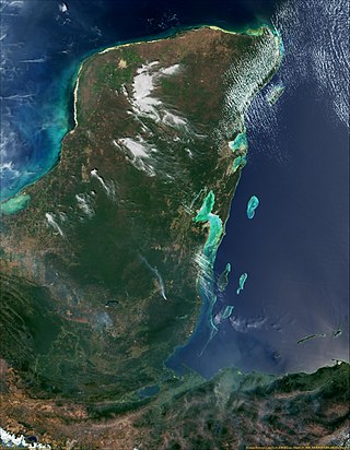
Belize is a small Central American nation, located at 17°15' north of the equator and 88°45' west of the Prime Meridian on the Yucatán Peninsula. It borders the Caribbean Sea to the east, with 386 km of coastline. It has a total of 542 km of land borders—Mexico to the north-northwest (272 km) and Guatemala to the south-southwest (266 km). Belize's total size is 22,966 km2 (8,867 sq mi), of which 22,806 km2 (8,805 sq mi) is land and 160 km2 (62 sq mi) is water.

Ambergris Caye, is the largest island of Belize, located northeast of the country's mainland, in the Caribbean Sea. It is about 40 kilometres (25 mi) long from north to south, and about 1.6 kilometres (1 mi) wide. Many parts of the island have been modified by human development since the arrival of coconut plantations in the 17th century, but it remains largely white coral sand with mangrove forest at its center. Its eastern coast runs parallel to the northernmost stretch of the Belize Barrier Reef, a UNESCO World Heritage Site.
The Gulf or Bay of Honduras is a large inlet of the Caribbean Sea, indenting the coasts of Belize, Guatemala, and Honduras. From north to south, it runs for approximately 200 km from Dangriga, Belize, to La Ceiba, Honduras.

Banco Chinchorro is an atoll reef lying off the southeast coast of the Municipality of Othón P. Blanco in Quintana Roo, Mexico, near Belize. It was featured throughout the 2009 semi-documentary film Alamar by Pedro González-Rubio.

The Maranhão mangroves is a mangrove ecoregion of northern Brazil. It supports half of the shorebird population of the country. The combination of flat land, heavy rainfall and high tides causes the mangroves to extend up to 40 kilometres (25 mi) inland, where they are interspersed with other rainforest species.

The Petén–Veracruz moist forests is an ecoregion of the tropical and subtropical moist broadleaf forest biome found in Belize, Guatemala, and Mexico.
Sarstoon-Temash is the southernmost national park in Belize. The national park was designated in 1994, and covers an area of 165.92 km2. It is managed by the Sarstoon Temash Institute for Indigenous Management (SATIIM), in partnership with the Forest Department.

The Belizean pine forests is an ecoregion that represents an example of lowland and premontane pine forests in the Neotropical realm, where the dominant tree species is Caribbean pine. The vegetation here is generally adapted to the xeric, acidic and nutrient-poor conditions along the Belizean near coastal zone of the Caribbean versant.
St. Peter Claver Catholic parish is located in Punta Gorda, Toledo District, Belize.

The Amazon–Orinoco–Southern Caribbean mangroves (NT1401) is an ecoregion along the coasts of Colombia, Venezuela, Guyana, Suriname, French Guiana and Brazil.

The Central American Atlantic moist forests ecoregion covers the lowland coastal forests of Honduras, southeast Guatemala, and the eastern forests of Nicaragua. Half of the ecoregion is closed-canopy tropical broadleaf evergreen forest, with tree heights reaching 50 meters. This ecoregion has the largest single fragment of natural forest in Central America, with a size of 14,629 square kilometres (5,648 sq mi). The total area is 89,979 square kilometres (34,741 sq mi).

The Mesoamerican Gulf-Caribbean mangroves ecoregion covers the series of disconnected mangrove habitats along the eastern coast of Central America. These salt-water wetlands are found in river deltas, lagoons, and low-lying areas facing the Gulf of Mexico and Caribbean Sea, from Tampico, Mexico to central Panama. The mangroves are areas of high biodiversity and endemism. Many of the sites are protected as national parks or nature reserves.

The Belizean reef mangroves ecoregion covers the mangrove habitats along the islands and cayes of the Belize Barrier Reef. This ecoregion is distinct from the mainland Belizean Coast mangroves ecoregion, and may be considered a sub-unit of the overall Mesoamerican Gulf-Caribbean mangroves ecoregion.

The Bocas del Toro-San Bastimentos Island-San Blas mangroves ecoregion covers the mangrove habitats along the Caribbean Sea coast of Costa Rica and across the northern coast of Panama. An offshore reef and barrier islands of the region help protect the mangroves from destructive waves. The ecoregion has a high number of endangered and threatened species, including the loggerhead sea turtle, green sea turtle, and hawk's bill sea turtle.

The Lesser Antilles mangroves ecoregion covers the salt-water habitats along the coasts of the islands on the divide between the Caribbean Sea and the Atlantic Ocean. the included islands stretch from Anguilla in the north to the island of Grenada in the south. The species diversity of these small islands is less than that of the larger islands of the Greater Antilles with to the west, but endemism is high due to the relative isolation of the different islands.
The Magdalena-Santa Marta mangroves ecoregion covers the mangrove forests along the coast of Colombia on the Caribbean Sea, from Gulf of Urabá in the west at the Colombia-Panama border to the Guajira Peninsula in the east. The region is relatively dry, with low precipitation and high evapotranspiration, so the mangroves depend for water and nutrients on the rivers flowing across the estuarine plain from the Sierra Nevada de Santa Marta mountains to the east. Efforts are currently underway to restore mangroves degraded by development and road building from the 1950s to 1980s.

The Moist Pacific Coast mangroves ecoregion covers a series of disconnected mangrove sites along the Pacific Ocean coast of Costa Rica and Panama. These sites occur mostly on coastal flatlands around lagoons, particularly where rivers from the inland mountains reach the sea, bringing fresh water to the coastal forests. The area is in a transition zone from the drier coastline to the north; rainfall in this ecoregions is over 2,000 mm/year, and reaches over 3,600 mm/year at the southern end.

The Mayan Corridor mangroves ecoregion covers the mangrove habitats along the Caribbean Sea coast of the state of Quintana Roo in southern Mexico and a narrow strip on the north of Belize. The region is named for the Maya Civilization archeological sites along the coast. Biodiversity in the area high due to the interactions of different environments - coastal lagoons, river estuaries, coral reefs, and barrier beaches. The ecoregion supports Mexico's largest population of crocodiles.

The Rio Piranhas mangroves ecoregion covers a series of mangrove forests along the Atlantic Ocean coast of the eastern tip of Brazil. The mangrove sections are spread across 350 km, from the mouth of the Mamanguape River in the north, to the vicinity of Maceió in the south. This coast is centered on the city of Recife, and the mangrove sections often surround industrial ports and cities.

The Trinidad mangroves ecoregion covers the separate mangrove forest areas on the coast of the island of Trinidad, in the country of Trinidad and Tobago. The character of the mangroves is affected by the large amount of fresh water flowing out of the Orinoco River and Amazon River to the south, which flow northwest around the island. The mangroves of Trinidad are found on all coasts, and are usually in the estuaries of rivers, but also found in coastal lagoons.

