Meiobenthos, also called meiofauna, are small benthic invertebrates that live in marine or freshwater environments, or both. The term meiofauna loosely defines a group of organisms by their size—larger than microfauna but smaller than macrofauna—rather than by their taxonomy. This fauna includes both animals that turn into macrofauna later in life, and those small enough to belong to the meiobenthos their entire life. In marine environments there can be thousands of individuals in 10 cubic centimeters of sediment, and counts animals like nematodes, copepods, rotifers, tardigrades and ostracods, but protists like ciliates and foraminifers within the size range of the meiobethos are also often included. In practice, the term usually includes organisms that can pass through a 1 mm mesh but are retained by a 45 μm mesh, though exact dimensions may vary. Whether an organism will pass through a 1 mm mesh also depends upon whether it is alive or dead at the time of sorting.

The benthic zone is the ecological region at the lowest level of a body of water such as an ocean, lake, or stream, including the sediment surface and some sub-surface layers. The name comes from the Ancient Greek word βένθος (bénthos), meaning "the depths". Organisms living in this zone are called benthos and include microorganisms as well as larger invertebrates, such as crustaceans and polychaetes. Organisms here generally live in close relationship with the substrate and many are permanently attached to the bottom. The benthic boundary layer, which includes the bottom layer of water and the uppermost layer of sediment directly influenced by the overlying water, is an integral part of the benthic zone, as it greatly influences the biological activity that takes place there. Examples of contact soil layers include sand bottoms, rocky outcrops, coral, and bay mud.

An abyssal plain is an underwater plain on the deep ocean floor, usually found at depths between 3,000 and 6,000 metres. Lying generally between the foot of a continental rise and a mid-ocean ridge, abyssal plains cover more than 50% of the Earth's surface. They are among the flattest, smoothest, and least explored regions on Earth. Abyssal plains are key geologic elements of oceanic basins.

A survey vessel is any type of ship or boat that is used for underwater surveys, usually to collect data for mapping or planning underwater construction or mineral extraction. It is a type of research vessel, and may be designed for the purpose, modified for the purpose or temporarily put into the service as a vessel of opportunity, and may be crewed, remotely operated, or autonomous. The size and equipment vary to suit the task and availability.

A pollen core is a core sample of a medium containing a stratigraphic sequence of pollen. Analysis of the type and frequency of the pollen in each layer is used to study changes in climate or land use using regional vegetation as a proxy. This analysis is conceptually comparable to the study of ice cores.

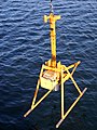
Sediment traps are instruments used in oceanography and limnology to measure the quantity of sinking particulate organic material in aquatic systems, usually oceans, lakes, or reservoirs. This flux of material is the product of biological and ecological processes typically within the surface euphotic zone, and is of interest to scientists studying the role of the biological pump in the carbon cycle.
Sediment Profile Imagery (SPI) is an underwater technique for photographing the interface between the seabed and the overlying water. The technique is used to measure or estimate biological, chemical, and physical processes occurring in the first few centimetres of sediment, pore water, and the important benthic boundary layer of water. Time-lapse imaging (tSPI) is used to examine biological activity over natural cycles, like tides and daylight or anthropogenic variables like feeding loads in aquaculture. SPI systems cost between tens and hundreds of thousands of dollars and weigh between 20 and 400 kilograms. Traditional SPI units can be effectively used to explore continental shelf and abyssal depths. Recently developed SPI-Scan or rSPI (rotational SPI) systems can now also be used to inexpensively investigate shallow (<50m) freshwater, estuarine, and marine systems.

The Albatross expedition (Albatrossexpeditionen) was a Swedish oceanographic expedition that between July 4, 1947, and October 3, 1948, sailed around the world during 15 months covering 45 000 nautical miles. The expedition is considered the second largest Swedish research expedition after the Vega expedition. The expedition was very successful, received international attention, and is considered one of the important steps in the history of oceanography.

The North Pacific Subtropical Gyre (NPSG) is the largest contiguous ecosystem on earth. In oceanography, a subtropical gyre is a ring-like system of ocean currents rotating clockwise in the Northern Hemisphere and counterclockwise in the Southern Hemisphere caused by the Coriolis Effect. They generally form in large open ocean areas that lie between land masses.

BENGAL was the acronym of the research project High-resolution temporal and spatial study of the BENthic biology and Geochemistry of a north-eastern Atlantic abyssal Locality. The project was funded through the EC MAST III program from 1996 to 1998.
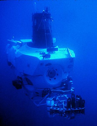
ABISMO is a remotely operated underwater vehicle (ROV) built by the Japan Agency for Marine-Earth Science and Technology (JAMSTEC) for exploration of the deep sea. It is the only remaining ROV rated to 11,000-meters, ABISMO is intended to be the permanent replacement for Kaikō, a ROV that was lost at sea in 2003.

An epibenthic sled is an instrument designed to collect benthic and benthopelagic faunas from the deep sea. The sled is made from a steel frame consisting of two skids and stabilizing planes to keep it from sinking too deep into the mud. Attached to the frame is a 1 mm mesh net to collect the samples. The sled is towed along the seafloor at the sediment water interface. The device has a mechanically operated door that is closed when the sled is mid water and opens when it reaches the seafloor. When the fauna is collected, the door closes again to preserve the sample on the long trek back through the water column. The door prevents washing of the sample and loss of organisms through turbulence generated as the net is lifted out. The epibenthic sled can also be used with external sensors and cameras.
Fishery Oceanographic Research Vessel Sagar Sampada is an Indian research vessel that is equipped to carry out multidisciplinary research in oceanography, marine biology and fishery science. This is the unique facility of the country equipped to undertake oceanography and fisheries (demersal) in the same platform. The vessel is currently managed and operated by the Centre for Marine Living Resources & Ecology (CMLRE), Kochi, a research institute attached to the Ministry of Earth Sciences, Government of India, and is operated from Kochi. FORV Sagar Sampada is a platform for interdisciplinary expeditions in and around the Indian Exclusive Economic Zone, and in International waters with participation from various institutions, from India and abroad.

The Van Veen grab sampler is an instrument to sample sediment in water environments. Usually it is a clamshell bucket made of stainless steel. Up to 20 cm deep samples of roughly 0.1 m2 can be extracted with this instrument. It can be light-weight and low-tech. The smallest version even fits into hand luggage. The sampler was invented by Johan van Veen in 1933.
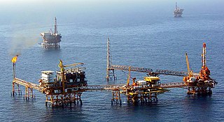
Offshore geotechnical engineering is a sub-field of geotechnical engineering. It is concerned with foundation design, construction, maintenance and decommissioning for human-made structures in the sea. Oil platforms, artificial islands and submarine pipelines are examples of such structures. The seabed has to be able to withstand the weight of these structures and the applied loads. Geohazards must also be taken into account. The need for offshore developments stems from a gradual depletion of hydrocarbon reserves onshore or near the coastlines, as new fields are being developed at greater distances offshore and in deeper water, with a corresponding adaptation of the offshore site investigations. Today, there are more than 7,000 offshore platforms operating at a water depth up to and exceeding 2000 m. A typical field development extends over tens of square kilometers, and may comprise several fixed structures, infield flowlines with an export pipeline either to the shoreline or connected to a regional trunkline.

The Young grab, or the Young modified Van Veen grab sampler is an instrument to sample sediment in the ocean. It is a modified version of the Van Veen grab sampler, with a clamshell bucket made out of stainless steel mounted to a supporting frame. The sampling area extracted with this instrument can vary depending on its size. With the modifications this version of the Van Veen grab sampler is heavier than the traditional version. The frame allows for better stability and level sampling. Weights can be attached to the frame to ensure the bucket grabs sufficient sediment, or skids to ensure the gear does not sink too deep in soft sediments.
USSP is a planned Submarine rescue ship of the Marina Militare, financed with 2017's balance law.
It is expected to replace Italian ship Anteo.

Scotoplanes globosa, commonly known as the sea pig, is a species of sea cucumber that lives in the deep sea. It was first described by Hjalmar Théel, a Swedish scientist. Scotoplanes globosa, along with numerous other sea cucumbers were discovered by Théel during an expedition on HMS Challenger between the years of 1873-1876. Scotoplanes globosa was officially described in 1882, 6 to 9 years after its first sighting. Scotoplanes globosa is most closely related to the genus Peniagone.
Cascadia Channel is the most extensive deep-sea channel currently known of the Pacific Ocean. It extends across Cascadia Abyssal Plain, through the Blanco Fracture Zone, and into Tufts Abyssal Plain. Notably, Cascadia Channel has tributaries, akin to river tributaries.
Underwater exploration is the exploration of any underwater environment, either by direct observation by the explorer, or by remote observation and measurement under the direction of the investigators. Systematic, targeted exploration is the most effective method to increase understanding of the ocean and other underwater regions, so they can be effectively managed, conserved, regulated, and their resources discovered, accessed, and used. Less than 10% of the ocean has been mapped in any detail, less has been visually observed, and the total diversity of life and distribution of populations is similarly obscure.