Dart or DART may refer to:

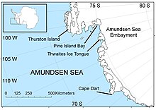
The Amundsen Sea is an arm of the Southern Ocean off Marie Byrd Land in western Antarctica. It lies between Cape Flying Fish to the east and Cape Dart on Siple Island to the west. Cape Flying Fish marks the boundary between the Amundsen Sea and the Bellingshausen Sea. West of Cape Dart there is no named marginal sea of the Southern Ocean between the Amundsen and Ross Seas. The Norwegian expedition of 1928–1929 under Captain Nils Larsen named the body of water for the Norwegian polar explorer Roald Amundsen while exploring this area in February 1929.

Siple Island is a 110 km (68 mi) long snow-covered island lying east of Wrigley Gulf along the Getz Ice Shelf off Bakutis Coast of Marie Byrd Land, Antarctica. Its centre is located at 73°51′S125°50′W.

Carney Island is an ice-covered island, 70 nautical miles long with all but its north coast lying within the Getz Ice Shelf, Antarctica. It is located between Siple Island and Wright Island along the coast of Marie Byrd Land.

The Getz Ice Shelf is an ice shelf over 300 nautical miles long and from 20 to 60 nautical miles wide, bordering the Hobbs Coast and Bakutis Coast of Marie Byrd Land, Antarctica, between the McDonald Heights and Martin Peninsula. Several large islands are partially or wholly embedded in the ice shelf.
The Gould Coast is a portion of the coast of Antarctica along the eastern margin of the Ross Ice Shelf at Amundsen Coast between the west side of Scott Glacier and the south end of the Siple Coast. It was named by the New Zealand Antarctic Place-Names Committee in 1961 for Laurence M. Gould, a geologist who was second-in-command of the Byrd Antarctic Expedition, 1928–30. Gould led the Geological Party which in 1929 mapped 175 miles (280 km) of this coast. While president of Carleton College, Northfield, Minnesota, he was appointed Chairman of the U.S. National Committee for the International Geophysical Year and took a prominent part in planning the United States research program for Antarctica.
Northeast Glacier is a steep, heavily crevassed glacier, 13 nautical miles long and 5 nautical miles wide at its mouth, which flows from McLeod Hill westward and then south-westwards into Marguerite Bay between the Debenham Islands and Roman Four Promontory, on the west coast of Graham Land, Antarctica.

The Dailey Islands are a group of small volcanic islands lying off the coast of Victoria Land, 9 kilometres (5 nmi) northeast of Cape Chocolate, in the northern part of the ice shelf bordering McMurdo Sound. They were discovered by the British National Antarctic Expedition, 1901–04, under Robert Falcon Scott, and named for Fred E. Dailey, the expedition carpenter.
King Peninsula is an ice-covered peninsula, 100 nautical miles long and 20 nautical miles wide, lying south of Thurston Island and forming the south side of Peacock Sound, Antarctica. It projects from the continental ice sheet and trends west between the Abbot Ice Shelf and Cosgrove Ice Shelf to terminate at the Amundsen Sea.
The Yee Nunataks are a group of scattered nunataks, about 24 nautical miles long and 12 nautical miles wide, centered 35 nautical miles northeast of Lyon Nunataks in Ellsworth Land, Antarctica. The nunataks rise 1,300–1,700 metres (4,300–5,600 ft) in elevation and in the four quadrants include Staack Nunatak, Olander Nunatak, Metzgar Nunatak and Triassic Nunatak.
Acosta Glacier is a glacier about 2 miles (3 km) long flowing north from Thurston Island just east of Dyer Point in Antarctica. It was named by the Advisory Committee on Antarctic Names (US-ACAN) after Alex V. Acosta of the United States Geological Survey (USGS) in Flagstaff, Arizona. He is a computer and graphic specialist, and was part of the USGS team that compiled the 1:5,000,000-scale Advanced Very High Resolution Radiometer satellite image maps of Antarctica and the 1:250,000-scale Landsat image maps of the Siple Coast area in the 1990s.
Armour Inlet is an ice-filled inlet indenting the north side of Siple Island just west of the Armour Peninsula, along the coast of Marie Byrd Land. The inlet was first roughly delineated from air photos taken by U.S. Navy Operation Highjump in January 1947, and named by the Advisory Committee on Antarctic Names for the Armour Institute of Technology, Chicago, which donated funds to the United States Antarctic Service, 1939–41, for purchase of the Snow Cruiser.
Armour Peninsula is an ice-covered peninsula situated immediately east of Armour Inlet on Siple Island, along the coast of Marie Byrd Land. It was mapped by the United States Geological Survey from ground surveys and from U.S. Navy air photos, 1959–65, and named by the Advisory Committee on Antarctic Names in association with Armour Inlet.
Burtis Island is a small island lying 19 kilometres (10 nmi) east of Cape Dart, Siple Island, off the coast of Marie Byrd Land. It was mapped by the U.S. Geological Survey from U.S. Navy aerial photography, 1962–65, and named by the Advisory Committee on Antarctic Names for William J. Burtis, an ionospheric physicist at Byrd Station in 1965.
Nereson Glacier is a glacier about 5 nautical miles (9 km) long draining the north side of Siple Island. Named by Advisory Committee on Antarctic Names (US-ACAN) after Nadine A. Nereson, University of Washington, glaciologist whose research in West Antarctica during the 1990s focused on the history of ice flow, and the past and present stability of the ice sheet.
Pankratz Bay is a bay in the western end of Siple Island, off the coast of Marie Byrd Land. The bay is just south of Lovill Bluff and opens on Wrigley Gulf. Mapped by United States Geological Survey (USGS) from surveys and U.S. Navy aerial photography, 1959–65. Named by Advisory Committee on Antarctic Names (US-ACAN) for Leroy M. Pankratz, United States Antarctic Research Program (USARP) geomagnetician and seismologist at Byrd Station in 1965.
Lovill Bluff is a rock and snow coastal bluff at the western end of Siple Island, off the coast of Marie Byrd Land, Antarctica. The bluff stands 14 nautical miles (26 km) southwest of the summit of Mount Siple and marks the north side of the entrance to Pankratz Bay. It was mapped by United States Geological Survey from surveys and U.S. Navy air photos, 1959–65, and was named by the Advisory Committee on Antarctic Names for James E. Lovill, the United States Antarctic Research Program meteorologist-in-charge at Byrd Station in 1965.
Hulbe Glacier is a glacier about 10 nautical miles (20 km) long draining the north side of Siple Island, Antarctica. It was named by the Advisory Committee on Antarctic Names after Christina Hulbe, faculty member of the University of Otago, New Zealand, and a theoretical and field researcher of ice motion in Antarctica.

Thurston Glacier is a glacier about 28 km (17 mi) long which drains the south-eastern slopes of Mount Siple on Siple Island. The glacier trends eastward and then east-north-eastward to reach the northern shore of the island. It was mapped by the United States Geological Survey (USGS) from surveys and United States Navy aerial photography, 1959–65.
Lauff Island is a small island lying 4 kilometres (2 nmi) north of Cape Dart, Siple Island, off the Bakutis Coast of Marie Byrd Land, Antarctica. Like its neighbor Maher Island, Lauff Island is a tuff cone. It was discovered and photographed from aircraft of U.S. Navy Operation Highjump, 1946–47, and was named by the Advisory Committee on Antarctic Names for Commander Bernard J. Lauff, U.S. Navy, Commanding Officer of USS Glacier (AGB-4) during Operation Deep Freeze, 1956–57.