The Baltic Sea is an arm of the Atlantic Ocean that is enclosed by Denmark, Estonia, Finland, Germany, Latvia, Lithuania, Poland, Russia, Sweden, and the North and Central European Plain.

Pomerania is a historical region on the southern shore of the Baltic Sea in Central Europe, split between Poland and Germany. The central and eastern part belongs to the West Pomeranian, Pomeranian and Kuyavian-Pomeranian voivodeships of Poland, while the western part belongs to the German states of Mecklenburg-Western Pomerania and Brandenburg.

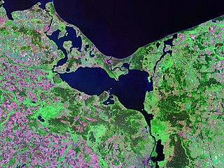
Sambia or Samland or Kaliningrad Peninsula is a peninsula in the Kaliningrad Oblast of Russia, on the southeastern shore of the Baltic Sea. The peninsula is bounded by the Curonian Lagoon to the north-east, the Vistula Lagoon in the southwest, the Pregolya River in the south, and the Deyma River in the east. As Sambia is surrounded on all sides by water, it is technically an island. Historically it formed an important part of the historic region of Prussia.
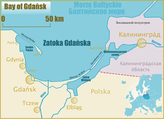
Gdańsk Bay or the Gulf of Gdańsk is a southeastern bay of the Baltic Sea. It is named after the adjacent port city of Gdańsk in Poland.
Szczecin Lagoon, also known as Oder Lagoon, and Pomeranian Lagoon, is a lagoon in the Oder estuary, shared by Germany and Poland. It is separated from the Pomeranian Bay of the Baltic Sea by the islands of Usedom and Wolin. The lagoon is subdivided into the Kleines Haff in the West and the Wielki Zalew in the East. An ambiguous historical German name was Frisches Haff, which later exclusively referred to the Vistula Lagoon.
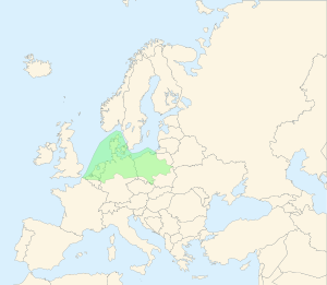
The East European Plain is a vast interior plain extending east of the North European Plain, and comprising several plateaus stretching roughly from 25 degrees longitude eastward. It includes Volhynian-Podolian Upland on its westernmost fringe, the Central Russian Upland, and, on the eastern border, encompasses the Volga Upland. The plain includes also a series of major river basins such as the Dnepr Basin, the Oka–Don Lowland, and the Volga Basin. At the southeastern point of the East European Plain are the Caucasus and Crimean mountain ranges. Together with the North European Plain, and covering the Baltic states, European Russia, Belarus, Ukraine, Moldova, southeastern Romania, and, at its southernmost point, the Danubian Plain in Northern Bulgaria, it constitutes the majority of the Great European Plain, the greatest mountain-free part of the European landscape. The plain spans approximately 4,000,000 km2 (2,000,000 sq mi) and averages about 170 m (560 ft) in elevation. The highest point of the plain, located in the Valdai Hills, is 346.9 metres (1,138.1 ft).

Europe is traditionally defined as one of seven continents. Physiographically, it is the northwestern peninsula of the larger landmass known as Eurasia ; Asia occupies the centre and east of this continuous landmass. Europe's eastern frontier is usually delineated by the Ural Mountains in Russia, which is the largest country by land area in the continent. The southeast boundary with Asia is not universally defined, but the modern definition is generally the Ural River or, less commonly, the Emba River. The boundary continues to the Caspian Sea, the crest of the Caucasus Mountains, and on to the Black Sea. The Bosporus, the Sea of Marmara, and the Dardanelles conclude the Asian boundary. The Mediterranean Sea to the south separates Europe from Africa. The western boundary is the Atlantic Ocean. Iceland is usually included in Europe because it is over twice as close to mainland Europe as mainland North America. There is ongoing debate on where the geographical centre of Europe falls.

The Pannonian Basin or Carpathian Basin is a large sedimentary basin situated in southeast Central Europe. After the Treaty of Trianon following World War I, the geomorphological term Pannonian Plain became more widely used for roughly the same region, referring to the lowlands in the area occupied by the Pannonian Sea during the Pliocene Epoch.
The Mazovian Lowland, also known as the Masovian Plain, is the largest geographical region in central Poland, roughly covering the historical region of Masovia. Sometimes it is also categorized as including Mazovian-Podlasian Lowlands which together form part of the greater North European Plain.

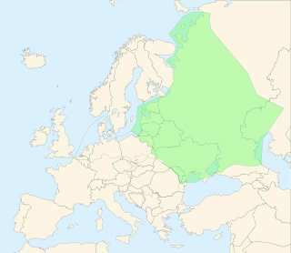
The European Plain or the Great European Plain is a plain in Europe and is a major feature of one of four major topographical units of Europe – the Central and Interior Lowlands. It is the largest mountain-free landform in Europe, although a number of highlands are identified within it.

Silesian Lowlands are lowlands located in Silesia, Poland in Central Europe. A small part is located in the Czech Republic. It is part of the Central European Plain. Silesian Lowlands is a physical-geographical macroregion. It is the warmest region in Poland.
Vistula Germans are ethnic Germans who had settled in what became known after the 1863 Polish rebellion as the Vistula Territory. This territory, so designated by the ruling Russians of the time, encompassed most of the Vistula river basin of central Poland up to just east of Toruń.

The Swiderian culture is an Upper Palaeolithic/Mesolithic cultural complex, centred on the area of modern Poland. The type-site is Świdry Wielkie, in Otwock near the Swider River, a tributary to the Vistula River, in Masovia. The Swiderian is recognized as a distinctive culture that developed on the sand dunes left behind by the retreating glaciers. Rimantienė (1996) considered the relationship between Swiderian and Solutrean "outstanding, though also indirect", in contrast with the Bromme-Ahrensburg complex, for which she introduced the term "Baltic Magdalenian" for generalizing all other North European Late Paleolithic culture groups that have a common origin in Aurignacian.

Sandomierz Basin is a lowland, located in southeastern Poland, between the Lesser Poland Upland, Lublin Upland and the Western Carpathians. Its name comes from the historical city of Sandomierz, and the basin has a triangular shape with the size of around 15,000 km2 (5,800 sq mi). It is drained by the Vistula River, as well as its eastern tributary, the San. Among major cities located in the Sandomierz Basin are Dębica, Jarosław, Mielec, Przemyśl, Przeworsk, Rzeszów, Stalowa Wola, Sandomierz, Tarnobrzeg, and Tarnów.

Polish regions are regions that are in present-day Poland but are not identified in its administrative division.

The North German Plain or Northern Lowland is one of the major geographical regions of Germany. It is the German part of the North European Plain. The region is bounded by the coasts of the North Sea and the Baltic Sea to the north, Germany's Central Uplands to the south, by the Netherlands to the west and Poland to the east.

The Oder is a river in Central Europe. It is Poland's second-longest river and third-longest within its borders after the Vistula and its largest tributary the Warta. The Oder rises in the Czech Republic and flows 742 kilometres (461 mi) through western Poland, later forming 187 kilometres (116 mi) of the border between Poland and Germany as part of the Oder–Neisse line. The river ultimately flows into the Szczecin Lagoon north of Szczecin and then into three branches that empty into the Bay of Pomerania of the Baltic Sea.

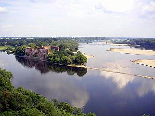
The Vistula is the longest river in Poland and the ninth-longest in Europe, at 1,047 kilometres in length. Its drainage basin, extending into three other countries apart from Poland, covers 193,960 km2 (74,890 sq mi), of which 168,868 km2 (65,200 sq mi) is in Poland.
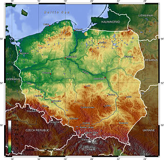
Poland is a country that extends across the North European Plain from the Sudetes and Carpathian Mountains in the south to the sandy beaches of the Baltic Sea in the north. Poland is the fifth-most populous country of the European Union and the ninth-largest country in Europe by area. The territory of Poland covers approximately 312,696 km2 (120,733 sq mi), of which 98.52% is land and 1.48% is water. The Polish coastline was estimated at 770 km (478 mi) in length. Poland's highest point is Rysy, at 2,500 m (8,202 ft).

The Vistula Lagoon is a brackish water lagoon on the Baltic Sea roughly 56 miles (90 km) long, 6 to 15 miles wide, and up to 17 feet (5 m) deep, separated from the Gdańsk Bay by the Vistula Spit.