The Baltic Sea is an arm of the Atlantic Ocean that is enclosed by Denmark, Estonia, Finland, Germany, Latvia, Lithuania, Poland, Russia, Sweden, and the North and Central European Plain.
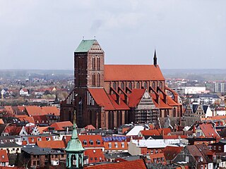
Wismar, officially the Hanseatic City of Wismar is, with around 43,000 inhabitants, the sixth-largest city of the northeastern German state of Mecklenburg-Vorpommern, and the fourth-largest city of Mecklenburg after Rostock, Schwerin and Neubrandenburg. The city was the third-largest port city in former East Germany after Rostock and Stralsund.

Poel or Poel Island, is an island in the Baltic Sea. It forms the natural northern and eastern boundaries of the Bay of Wismar on the German coast. The northern coast of the island is also on the south side of the large gulf known as the Bay of Mecklenburg, which Wismar Bay enters into. Insel Poel thus forms on its northern side the unofficial latitude of the northern boundary of the Wismar Bay.
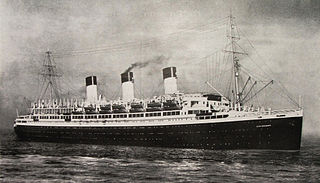
SS Cap Arcona, named after Cape Arkona on the island of Rügen, was a large German ocean liner, later a requisitioned auxiliary ship of the Kriegsmarine, and finally a prison ship in the later months of World War II (1939–1945). A flagship of the Hamburg Südamerikanische Dampfschifffahrts-Gesellschaft, she made her maiden voyage on 29 October 1927, carrying passengers and cargo between Germany and the east coast of South America, and for a brief period of time she was the largest and fastest ship on the route, until one month later she was surpassed on the same Europe-South America route by the Italian liner MS Augustus.

The Bay of Lübeck is a basin in the southwestern Baltic Sea, off the shores of the German states of Mecklenburg-Vorpommern and Schleswig-Holstein. It forms the southwestern part of the Bay of Mecklenburg.

The Bay of Kiel or Kiel Bay is a bay in the southwestern Baltic Sea, off the shores of Schleswig-Holstein in Germany and the islands of Denmark. It is connected with the Bay of Mecklenburg in the east, the Little Belt in the northwest, and the Great Belt in the North.
The Victual Brothers were a loosely organized guild of privateers who later turned to piracy. They affected maritime trade during the 14th century in both the North and Baltic Seas.

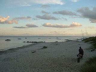
Boltenhagen is a German seaside resort in Mecklenburg-Vorpommern situated on the Baltic Sea coast 30 km east of Lübeck. It has a wide view of the Bay of Lübeck; a 5 km stretch of a wide and sandy beach, a boardwalk, restaurants and health spas. Boltenhagen is considered to be part of the German Riviera.

Walfisch is an uninhabited German island, in the Bay of Mecklenburg in the Baltic Sea. It lies approximately 4.5 kilometres (2.8 mi) north of the city of Wismar, south of the island of Poel. The island is very flat and has a maximum circumference of about 500 by 300 metres, a surface area of 20 hectares and is a nature reserve.

Dassow is a town in the Nordwestmecklenburg district, in Mecklenburg-Western Pomerania, Germany. It is situated on a bay of the Baltic Sea, 20 km east of Lübeck and 2 km south of Lübeck-Travemünde. It is also close to the cities of Wismar and Schwerin, and is part of the Hamburg Metropolitan Region.
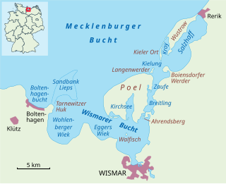
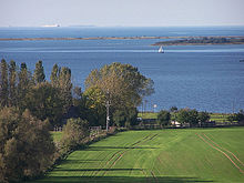
The Bay of Wismar or more commonly Wismar Bay or Wismarbucht is a well sheltered multi-sectioned bay in the southwestern Baltic Sea, in Mecklenburg-Vorpommern, Germany, and is considered the south-central part of the much larger arm of the Baltic known as the Mecklenburg Bay —a long fingerlike gulf oriented to the west-southwest (WSW) from the (central) Baltic proper. Wismar bay is considered one of the finest natural harbors on the Baltic, and served as the destination for much seaborne shipping until circa the 1910s when its minimum depths of 5 meters (16 ft) became too shallow for larger more modern ships. Today, because of the shallow sheltered waters the bay is the subject of much research via underwater archeology

Eckernförde Bay is a firth and a branch of the Bay of Kiel between the Danish Wahld peninsula in the south and the Schwansen peninsula in the north in the Baltic Sea off the lands of Schleswig-Holstein, Germany. The bay extends around 17 km (11 mi) deep into the land and is 10 km (6.2 mi) wide at its entrance where Booknis-Eck and Danish-Nienhof mark the endpoints. The bay is up to 28 m (92 ft) deep. The border to the Kiel Fjord lies at the Bülk Lighthouse. The once forested Danish Wahld peninsula between Kiel Fjord and Eckernförde Bay constituted the borderland between the Saxons and the Danes until the Middle Ages. At the inner end of the bay lies the town of Eckernförde.
Despite its name, the Dassower See , sometimes called Lake Dassow or Dassow Bay in English, is not a lake, but a side bay, locally known as a wiek, of the Trave Fjord, northeast of Lübeck (Schleswig-Holstein) on the Baltic Sea.
The Klützer Winkel or Klützer Ort is a part of the Nordwestmecklenburg district, in Mecklenburg-Western Pomerania, Germany. It is in the western part of the district on the Baltic Sea between the Hanseatic towns of Lübeck (Priwall) and Wismar, north of Grevesmühlen and centred on Klütz. The hilly landscape of the Klützer Winkel was formed during the last ice age. Its highest points are the Hohe Schönberg, at 89 metres above mean sea level, and the Heideberg. The Klützer Winkel may also be considered a peninsula between the Bay of Lübeck and Bay of Mecklenburg, because from a line between the Dassower See and Wohlenberger Wiek it extends up to 10 km to the north. The area has a number of tourist attractions such as the Baltic Sea cliffs, the spa resort of Boltenhagen, the town of Klütz with its castle, Schloss Bothmer, and the railway museum as well as various other castles such as the castle of Gross-Schwansee, today a luxury hotel.

Dorf Mecklenburg is a municipality in the Nordwestmecklenburg district, in Mecklenburg-Vorpommern, Germany. It is located 6 km south of Wismar. It is home to the castle "Mikilenburg", that gave its name to the whole region known as Mecklenburg.

Mühlenteich is a lake in Wismar, Mecklenburg-Vorpommern, Germany. Its elevation is 4 m (13 ft) and its surface area is 0.482 km2 (0.186 sq mi). The water body is highly indented. There is a prominent southern bay with two smaller islands and a distinct northern bay. The Mühlenteich has a north-south extension of about 1700 metres and a west-east extension of about 400 metres. Large parts of the pond shore, especially in the south, are marshy and mostly silted up. The Wallenstein Ditch, which is dammed in the pond, flows into it in the southwest and leaves it again in the north. In addition, the Mühlenbach flows off in the west through the inner city towards the Baltic Sea. Another tributary is a ditch from the south-east. The south-western part of the water body belongs to the nature reserve Teichgebiet Wismar-Kluß. The pond is used for commercial trout farming.

Hohwacht Bay is a wide bay in the state of Schleswig-Holstein on Germany's Baltic Sea coastline. It is named after the village and seaside resort of Hohwacht. The nearest large town is Oldenburg in Holstein, about 5 kilometres inland. A number of nature reserves fringe the bay and there is a military training area along its eastern shore.

Neuland Lighthouse is a lighthouse in the north German state of Schleswig-Holstein on the Baltic Sea coast that was in service from 1918 to 1996. It stands on the western shore of Hohwacht Bay about 1 kilometre north of the village of Behrensdorf.

The Dueodde Lighthouse is located on the Danish island of Bornholm. It was built during the years 1960–62 and commissioned on 15 August 1962. It is 47 m (154 ft) in height, with a focal height of 48 m (157 ft). It is the nodal point of the southeast coast line, warning ships to keep away from the extreme southern tip of the island. Dueodde Lighthouse is Denmark's tallest lighthouse and one of the most important lighthouses of the Baltic Sea.
The Bay of Neustadt or Neustadt Bay is a sub-bay within the Bay of Lübeck which, in turn, is part of the Bay of Mecklenburg in the Baltic Sea.