This article needs additional citations for verification .(July 2012) |
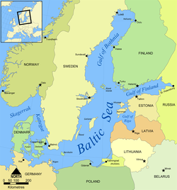
Bodies of water of brackish nature are found around the world in a wide variety of settings, shapes and sizes. The following is a list of notable bodies of brackish water.
Brackish water, sometimes termed brack water, is water occurring in a natural environment that has more salinity than freshwater, but not as much as seawater. It may result from mixing seawater and fresh water together, as in estuaries, or it may occur in brackish fossil aquifers. The word comes from the Middle Dutch root brak. Certain human activities can produce brackish water, in particular civil engineering projects such as dikes and the flooding of coastal marshland to produce brackish water pools for freshwater prawn farming. Brackish water is also the primary waste product of the salinity gradient power process. Because brackish water is hostile to the growth of most terrestrial plant species, without appropriate management it can be damaging to the environment.
The St. Lawrence River is a large international river in the middle latitudes of North America connecting the Great Lakes to the North Atlantic Ocean. Its waters flow in a northeasterly direction from Lake Ontario to the Gulf of St. Lawrence, traversing Ontario and Quebec in Canada and New York in the United States. A section of the river demarcates the Canada–U.S. border.
An estuary is a partially enclosed coastal body of brackish water with one or more rivers or streams flowing into it, and with a free connection to the open sea. Estuaries form a transition zone between river environments and maritime environments and are an example of an ecotone. Estuaries are subject both to marine influences such as tides, waves, and the influx of saline water, and to fluvial influences such as flows of freshwater and sediment. The mixing of seawater and freshwater provides high levels of nutrients both in the water column and in sediment, making estuaries among the most productive natural habitats in the world.
A lagoon is a shallow body of water separated from a larger body of water by a narrow landform, such as reefs, barrier islands, barrier peninsulas, or isthmuses. Lagoons are commonly divided into coastal lagoons and atoll lagoons. They have also been identified as occurring on mixed-sand and gravel coastlines. There is an overlap between bodies of water classified as coastal lagoons and bodies of water classified as estuaries. Lagoons are common coastal features around many parts of the world.
A ria is a coastal inlet formed by the partial submergence of an unglaciated river valley. It is a drowned river valley that remains open to the sea.
Pulicat Lake is the second largest brackish water lagoon in India,, measuring 759 square kilometres (293 sq mi). A major part of the lagoon lies in the Tirupati district of Andhra Pradesh. The lagoon is one of three important wetlands that attracts northeast monsoon rain clouds during the October to December season. The lagoon comprises the following regions: Pulicat Lake, Marshy/Wetland Land Region (AP), Venadu Reserve Forest (AP), and Pernadu Reserve Forest (AP). The lagoon was cut across in the middle by the Sriharikota Link Road, which divided the water body into lagoon and marshy land. The lagoon encompasses the Pulicat Lake Bird Sanctuary. The barrier island of Sriharikota separates the lagoon from the Bay of Bengal and is home to the Indian Space Research Organisation's Satish Dhawan Space Centre.
Chilika Lake is the largest brackish water lagoon in Asia and second largest coastal lagoon in the world, covering an area of over 1,100 square kilometres (420 sq mi). It is spread over the Puri, Khordha and Ganjam districts of Odisha state on the east coast of India, at the mouth of the Daya River, flowing into the Bay of Bengal.
A liman is an enlarged estuary formed as a lagoon at the wide mouth of one or several rivers, where flow is nearly fully or partially constrained by a mouth bar of sediments (peresyp), as in the Dniester Liman or the Razelm liman. A liman can be maritime or fluvial. The term describes many wet estuaries in the Black Sea and the Sea of Azov; a synonymous term guba (губа) is used in Russian sources for estuaries of the Russian shores in the north.
The St. Lucie River is a 35-mile-long (56 km) estuary linked to a coastal river system in St. Lucie and Martin counties in the U.S. state of Florida. The St. Lucie River and St. Lucie Estuary are an "ecological jewel" of the Treasure Coast, central to the health and well-being of the surrounding communities. The river is part of the larger Indian River Lagoon system, the most diverse estuarine environment in North America with more than 4,000 plant and animal species, including manatees, oysters, dolphins, sea turtles and seahorses.
Victorella pavida or trembling sea mat is a species of bryozoan found in shallow waters of low or fluctuating salinity, such as lagoons and estuaries. In summer it can have the appearance of velvet. The zooids may be from 0.3 mm to 1 mm in length. They live in colonies underwater attaching to stones. They feed using tiny hairs attached to their crown of tentacles to catch tiny particles flowing through the water, also known as "filter feeding".
Condado Lagoon is located in San Juan, Puerto Rico. It is an effluent body of water that flows freely between the Condado and Miramar neighborhoods of Santurce, a barrio of San Juan.
Classification of wetlands has been a problematical task, with the commonly accepted definition of what constitutes a wetland being among the major difficulties. A number of national wetland classifications exist. In the 1970s, the Ramsar Convention on Wetlands of International Importance introduced a first attempt to establish an internationally acceptable wetland classification scheme.
Tourism in Odisha is one of the main contributors to the economy of Odisha, India, with a 500 km (310 mi) long coastline, mountains, lakes, natural biodiversity and rivers. Odisha is a major tourist destination in India, with various tourist attractions, including wildlife reserves, beaches, temples, monuments, the arts and festivals. Other than wildlife reserves, beaches, temples, monuments, the arts and festivals, the Odisha Tourism Development Corporation, a public sector undertaking of the Government of Odisha, is also developing the tourism sector of Odisha and India.
Odisha, a state in eastern India, is extremely diverse and gives the state abundance of natural beauty and wildlife. The districts in the interior are thickly covered by tropical moist deciduous and tropical dry deciduous forests. The hills, plateaus and isolated areas of the northeastern part of the state are covered by the tropical moist deciduous forests whereas the dry deciduous forests are located in the southwest region of the state. Some of the trees which grow in abundance in Odisha are bamboo, teak, rosewood, sal, piasal, sanghvan and haldi. There are 479 species of birds, 86 species of mammals, 19 species of amphibians and 110 species of reptiles present in Odisha. The state is also an important habitat for the endangered olive ridley turtles and Irrawaddy dolphins. Koraput district of southern Odisha has been identified by Food and Agriculture Organisation (FAO) of UN as Global Agricultural Heritage site which is among only other three sites in the world. Other sites are in Peru, China and Philippines.
The Laguna Madre is a long, shallow, hypersaline lagoon along the western coast of the Gulf of Mexico in Nueces, Kenedy, Kleberg, Willacy and Cameron Counties in Texas, United States. It is one of seven major estuaries along the Gulf Coast of Texas. The roughly 20-mile (32 km) long Saltillo Flats land bridge divides it into Upper and Lower lagoons joined by the Intracoastal Waterway, which has been dredged through the lagoon. Cumulatively, Laguna Madre is approximately 130 miles (210 km) long, the length of Padre Island in the US. The main extensions include Baffin Bay in Upper Laguna Madre, Red Fish Bay just below the Saltillo Flats, and South Bay near the Mexican border. As a natural ecological unit, the Laguna Madre of the United States is the northern half of the ecosystem as a whole, which extends into Tamaulipas, Mexico approximately 144 miles (232 km) south of the US border, to the vicinity of the Rio Soto La Marina and the town of La Pesca, extending approximately 275 miles (443 km) through USA and Mexico in total.
Lough Furnace is a tidally-influenced, meromictic, saline lagoon in County Mayo, Ireland, located south of Lough Feeagh. It receives freshwater inflow from the upstream Lough Feeagh at the base of the Burrishoole Catchment and tidal input of saline water from Clew Bay, through the Burrishoole Estuary.
St. Lawrence River Estuary stretches from west to east for 655 km, from the outlet of Lake Saint Pierre to Pointe-des-Monts, where it becomes the Gulf of St. Lawrence, in Quebec, Canada.
The U.S. state of Texas has a series of estuaries along its coast on the Gulf of Mexico, most of them bounded by the Texas barrier islands. Estuaries are coastal bodies of water in which freshwater from rivers mixes with saltwater from the sea. Twenty-one drainage basins terminate along the Texas coastline, forming a chain of seven major and five minor estuaries: listed from southwest to northeast, these are the Rio Grande Estuary, Laguna Madre, the Nueces Estuary, the Mission–Aransas Estuary, the Guadalupe Estuary, the Colorado–Lavaca Estuary, East Matagorda Bay, the San Bernard River and Cedar Lakes Estuary, the Brazos River Estuary, Christmas Bay, the Trinity–San Jacinto Estuary, and the Sabine–Neches Estuary. Each estuary is named for its one or two chief contributing rivers, excepting Laguna Madre, East Matagorda Bay, and Christmas Bay, which have no major river sources. The estuaries are also sometimes referred to by the names of their respective primary or central water bodies, though each also includes smaller secondary bays, inlets, or other marginal water bodies.
{{cite web}}
: CS1 maint: archived copy as title (link){{cite web}}
: CS1 maint: archived copy as title (link)