
The cultural heritage of Kaliningrad Oblast is a mixture of the pre-World War II German, Lithuanian and Polish heritage, dating back to the Ducal Prussian and East Prussian periods, and the Soviet and Russian designs constructed since then.
The cultural heritage of Kaliningrad Oblast is a mixture of the pre-World War II German, Lithuanian and Polish heritage, dating back to the Ducal Prussian and East Prussian periods, and the Soviet and Russian designs constructed since then.
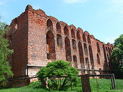
Many heritage sites in Kaliningrad Oblast were damaged during World War II, or willfully destroyed in the postwar period by Soviet authorities. [1] A number of landmarks did survive, such as the gothic Königsberg Cathedral containing the tomb of Kant, or the Königsberg Stock Exchange building. [2] Already in the 1960s, a group of local architects and intellectuals began to campaign for the preservation of the region's German heritage, albeit unsuccessfully. [3]
The first Soviet housing blocks were built only in 1966. [4] The spread of Soviet-style prefabricated panel buildings eventually changed the appearance of Kaliningrad. The 1970s House of Soviets is another part of the local Soviet architectural period. [2]
Mirroring the rediscovery of pre-revolutionary history in the rest of Russia, since 1991 there have been many efforts to recover the prewar heritage sites of Kaliningrad. [1] Preservation and reconstruction efforts are hampered by a complicated property ownership situation, as during the 1990s the city administration raised cash by selling land for construction without regard for central planning. [5]
Old buildings are being restored, and new ones built in conscious imitation of the old Königsberg architecture. [3] Some local architects are cautious about the reconstruction efforts, worried that the result may end up looking too kitsch and unauthentic. [5]
Königsberg Cathedral was successfully restored from 1992 to 1998, in a joint Russian-German project. [3] The Fischerdorf development, while being a new development, is a city quarter that intentionally mirrors the prewar architectural styles. [3] A project to restore Kant's House in Veselovka was announced in 2013, and should be completed in time for the 2018 World Cup. [6]
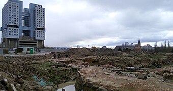
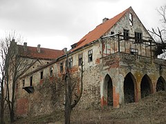
The ruins of Königsberg Castle are being excavated, with a plan to preserve them under a transparent enclosure. [7]
| | This section needs expansion. You can help by adding to it. (May 2024) |
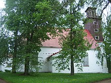
The eastern part of the current Kaliningrad Oblast was part of the region of Lithuania Minor, traditionally inhabited by Lithuanian people, and preserved Lithuanian heritage is thus mostly located there. In Chistye Prudy (Lithuanian : Tolminkiemis), there is a Memorial Museum of Kristijonas Donelaitis, author of The Seasons , the first Lithuanian poem. Several churches, which hosted Lithuanian services for the region's Lithuanian population in the past, are located in the province, including the preserved churches in Slavsk (Gastos) and Saranskoe (Laukiška) and ruins in Chernyshevskoye (Eitkūnai), Kalinino (Mielkiemis), Ozyorsk (Darkiemis) and Ulyanovo (Kraupiškas). The Lithuanian Church in Sovetsk (Tilžė), traditional capital of Lithuania Minor, [8] was destroyed by the Soviets in 1951–1952.
| | This section needs expansion. You can help by adding to it. (May 2024) |

Polish people historically inhabited especially Königsberg (Polish : Królewiec), the current southern border strip, plus some locations in the central (e.g. Chernyakhovsk/Wystruć, Znamensk/Welawa and Zagorskoye) and northern parts of the current oblast.
The former Polish Church at Steindamm (Polish : Kamienna Grobla), the main Polish Church of Königsberg (Królewiec) and the city's oldest church, where Jan Seklucjan, publisher of the oldest Polish translation of the New Testament, was a pastor in the mid-16th century, [9] was demolished by the Soviet administration in 1950. In 1972, the Soviets destroyed the main church of Chernyakhovsk (Wystruć), which also hosted Polish services in the past. The Königsberg Cathedral was historically also a place of worship for local Poles with Polish-language services held there until the 18th century. It contains the epitaph of 17th-century Polish princely magnate Bogusław Radziwiłł and his wife Anna Maria, renovated in 2007–2008 with funds from the Polish Ministry of Culture and National Heritage. [10]
A number of villages in the current southern border strip were founded by Poles several centuries ago, e.g. Kazachye (Piątki), Nekrasovo (Karpowo Wielkie), Maltsevo (Karpówko) near Krylovo (Nordenbork), [11] and Chorzele and Chorzelki near Mamonovo (Święta Siekierka). [12] In 1945, the southern border strip even initially passed under Polish control with Polish administration organized in the towns of Gierdawy and Iławka, however, the Polish administration was eventually expelled and the area was annexed by the Soviet Union and included within the Kaliningrad Oblast. [13]
In 2011, a Polish-built monument with Polish and Russian inscriptions was unveiled at the site of the former Hohenbruch concentration camp at Gromovo where Nazi Germany imprisoned mostly Poles, especially intelligentsia. [14]


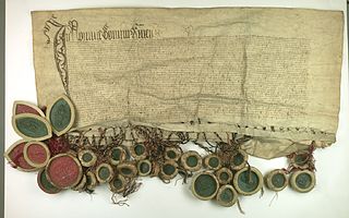
The Prussian Confederation was an organization formed on 21 February 1440 at Kwidzyn by a group of 53 nobles and clergy and 19 cities in Prussia, to oppose the arbitrariness of the Teutonic Knights. It was based on an earlier similar organization, the Lizard Union established in 1397 by the nobles of Chełmno Land.

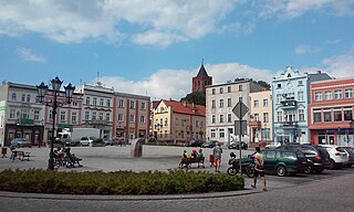
Chernyakhovsk, known prior to 1946 by its German name of Insterburg, is a town in Kaliningrad Oblast, Russia, and the administrative center of Chernyakhovsky District. Located at the confluence of the Instruch and Angrapa rivers, which unite to become the Pregolya river below Chernyakhovsk, the town had a population in 2017 of 36,423.

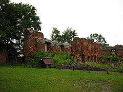
Balga was a medieval castle of the Teutonic Knights in Kaliningrad Oblast, Russia. The castle ruins are located on the shore of the Vistula Lagoon, north of Mamonovo in the Pogranichny municipality of Bagrationovsky District, about 30 km (19 mi) southwest of Kaliningrad.
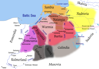
Natangians or Notangians was a Prussian clan, which lived in the region of Natangia, an area that is now mostly part of the Russian exclave Kaliningrad Oblast, whereas the southern portion lies in the Polish Warmian-Masurian Voivodeship.

Kulm law, Culm law or Chełmno Law was a legal constitution for a municipal form of government used in several Central European cities in the Middle Ages and early modern period.

The borders of Russia changed through military conquests and by ideological and political unions from the 16th century.
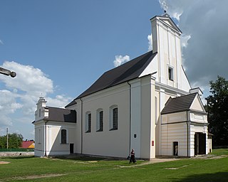
Saranskoe, Saranskoye is a rural locality (selo) in Kaliningrad Oblast. It lies approximately 11 kilometres (7 mi) east of Polessk.

Varniai is a city in the Telšiai County, western Lithuania. In the Middle Ages the city was known as Medininkai.

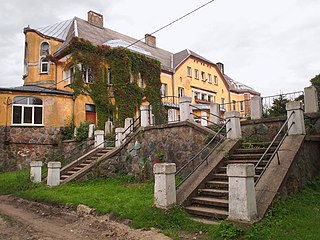
Bolshakovo, also referred to as Bolshakovo-Novoye, is a settlement located in the southern part of Slavsky District of Kaliningrad Oblast, Russia, 90 km from Kaliningrad. The adjective "Novoye" (new) is sometimes used to distinguish it from an eponymous village in Ivanovo Oblast of Russia.

Pervomaisk is a city in Mykolaiv Oblast, Ukraine. It serves as the administrative center of Pervomaisk Raion within the oblast. It is located on the Southern Bug River which bisects the city. Pervomaisk also hosts the administration of Pervomaisk urban hromada, one of the hromadas of Ukraine. Population: 62,426 ; 70,170 (2001).

Mayakovskoye is a rural locality in Gusevsky District of Kaliningrad Oblast, Russia, located on the banks of the Angrapa River. It lies approximately 11 kilometres (7 mi) south-west of Gusev.
Nowe is a town in Świecie County, Kuyavian-Pomeranian Voivodeship, Poland, with 6,270 inhabitants (2004). It is located within the ethnocultural region of Kociewie.

Polish historic regions are regions that were related to a former Polish state, or are within present-day Poland, with or without being identified in its administrative divisions.

Nesterov, until 1938 known by its German name Stallupönen and in 1938-1946 as Ebenrode, is a town and the administrative center of Nesterovsky District in Kaliningrad Oblast, Russia, located 140 kilometers (87 mi) east of Kaliningrad, near the Russian-Lithuanian border on the railway connecting Kaliningrad Oblast with Moscow. Population figures: 4,595 (2010 Census); 5,049 (2002 Census); 4,826 (1989 Soviet census).

Domnovo is a rural locality in Pravdinsky District of Kaliningrad Oblast, Russia, located near the Poland–Russia border, about 40 kilometers (25 mi) southeast of Kaliningrad, the administrative center of the oblast, and 12 kilometers (7.5 mi) west of Pravdinsk, the administrative center of the district. Population: 820.
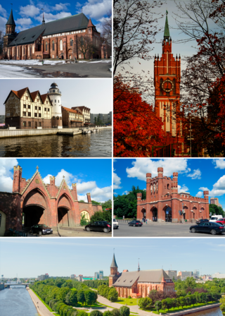
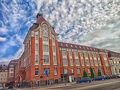
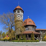
Kaliningrad, known as Königsberg until 1946, is the largest city and administrative centre of Kaliningrad Oblast, a Russian exclave between Lithuania and Poland. The city sits about 663 kilometres (412 mi) west of the bulk of Russia. The city is situated on the Pregolya River, at the head of the Vistula Lagoon on the Baltic Sea, and is the only ice-free Russian port on the Baltic Sea. Its population in 2020 was 489,359. Kaliningrad is the second-largest city in the Northwestern Federal District, after Saint Petersburg, the third-largest city in the Baltic region, and the seventh-largest city on the Baltic Sea.
Donskoye is a rural locality in the Ozyorsky District in the Kaliningrad Oblast, Russia. Population: 27 (2010 Census);
Hyeranyony is an agrotown in Iwye District, Grodno Region, Belarus. It serves as the administrative center of Hyeranyony selsoviet. It is located near the border with Lithuania and is known for the 16th-century Hieraniony Castle built by Albertas Goštautas. The village had a population of 1,278 in 2010.
Krylovo is a rural locality in Pravdinsk Urban Okrug, Pravdinsky District, Kaliningrad Oblast, Russia, on the border with Poland. Population: 785 (2010 Census); 756 (2002 Census); 2,291 (1905).
{{cite book}}: CS1 maint: location missing publisher (link){{cite book}}: CS1 maint: location missing publisher (link){{cite book}}: CS1 maint: location missing publisher (link)