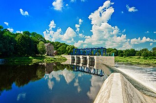
Gvardeysk, known prior to 1946 by its German name Tapiau (help·info), is a town and the administrative center of Gvardeysky District in Kaliningrad Oblast, Russia, located on the right bank of the Pregolya River 38 kilometers (24 mi) east of Kaliningrad, the administrative center of the oblast. Population: 13,899 (2010 Census); 14,572 (2002 Census); 11,904 (1989 Census).

Polessk, prior to 1946 known by its German name Labiau, is a town and the administrative center of Polessky District in Kaliningrad Oblast, Russia, located 49 kilometers (30 mi) northeast of Kaliningrad, the administrative center of the oblast, at the junction of a main road and a railroad at the Deyma River, shortly before it enters the Curonian Lagoon. Population: 7,581 (2010 Census); 7,681 (2002 Census); 6,859 (1989 Census); 4,744 (1885).

Slavsk, prior to 1946 known by its German name Heinrichswalde, is a town and the administrative center of Slavsky District in Kaliningrad Oblast, Russia, located 105 kilometers (65 mi) northeast of Kaliningrad, the administrative center of the oblast. Population: 4,614 (2010 Census); 5,172 (2002 Census); 4,682 (1989 Census).

Pionersky is a town in Kaliningrad Oblast, Russia, located along the Baltic Sea on the Sambian Peninsula, between Zelenogradsk and Svetlogorsk. Population: 11,016 (2010 Census); 11,816 (2002 Census); 11,635 (1989 Census). In the town there are a Residence of the President of the Russian Federation "Yantar" and the only Federal Children's orthopedic sanatorium in Russia "Pionersk".

Bagrationovsky District is an administrative district (raion), one of the fifteen in Kaliningrad Oblast, Russia. As a municipal division, it is incorporated as Bagrationovsky Municipal District. It is located in the southwest of the oblast. The area of the district is 1,146 square kilometers (442 sq mi). Its administrative center is the town of Bagrationovsk. Population: 32,352 (2010 Census); 45,672 ; 39,724 (1989 Census). The population of Bagrationovsk accounts for 19.8% of the district's total population.
Chernyakhovsky District is an administrative district (raion), one of the fifteen in Kaliningrad Oblast, Russia. As a municipal division, it is incorporated as Chernyakhovsky Municipal District. It is located in the center of the oblast. The area of the district is 1,285.75 square kilometers (496.43 sq mi). Its administrative center is the town of Chernyakhovsk. Population: 51,936 (2010 Census); 57,521 ; 12,806 (1989 Census). The population of Chernyakhovsk accounts for 77.9% of the district's total population.

Guryevsky District is an administrative district (raion), one of the fifteen in Kaliningrad Oblast, Russia. As a municipal division, it is incorporated as Guryevsky Urban Okrug. It is located in the west of the oblast. The area of the district is 1,284 square kilometers (496 sq mi). Its administrative center is the town of Guryevsk. Population: 52,988 (2010 Census); 47,330 ; 39,148 (1989 Census). The population of Guryevsk accounts for 23.5% of the district's total population.

Gusevsky District is an administrative district (raion), one of the fifteen in Kaliningrad Oblast, Russia. As a municipal division, it is incorporated as Gusevsky Urban Okrug. It is located in the east of the oblast. The area of the district is 654.9 square kilometers (252.9 sq mi). Its administrative center is the town of Gusev. Population: 37,142 (2010 Census); 37,461 ; 7,533 (1989 Census). The population of Gusev accounts for 76.1% of the district's total population.
Gvardeysky District is an administrative district (raion), one of the fifteen in Kaliningrad Oblast, Russia. It is located in the center of the oblast. The area of the district is 783 square kilometers (302 sq mi). Its administrative center is the town of Gvardeysk. Population: 29,926 (2010 Census); 32,101 ; 27,299 (1989 Census). The population of Gvardeysk accounts for 46.4% of the district's total population.
Krasnoznamensky District is an administrative district (raion), one of the fifteen in Kaliningrad Oblast, Russia. It is located in the northeast of the oblast. The area of the district is 1,280.47 square kilometers (494.39 sq mi). Its administrative center is the town of Krasnoznamensk. As of the 2010 Census, the total population of the district was 12,905, with the population of Krasnoznamensk accounting for 27.3% of that number.

Nemansky District is an administrative district (raion), one of the fifteen in Kaliningrad Oblast, Russia. As a municipal division, it is incorporated as Nemansky Municipal District. It is located in the north of the oblast. The area of the district is 699.3 square kilometers (270.0 sq mi). Its administrative center is the town of Neman. Population: 20,132 (2010 Census); 22,536 ; 8,904 (1989 Census). The population of Neman accounts for 58.6% of the district's total population.

Nesterovsky District is an administrative district (raion), one of the fifteen in Kaliningrad Oblast, Russia. As a municipal division, it is incorporated as Nesterovsky Municipal District. It is located in the southeast of the oblast and borders with Krasnoznamensky District in the north, Lithuania in the east, Poland in the south, and with Gusevsky and Ozyorsky Districts in the west. The area of the district is 1,062 square kilometers (410 sq mi). Its administrative center is the town of Nesterov. Population: 16,213 (2010 Census); 17,250 ; 15,181 (1989 Census). The population of Nesterov accounts for 28.3% of the district's total population.

Ozyorsky District is an administrative district (raion), one of the fifteen in Kaliningrad Oblast, Russia. It is located in the southeast of the oblast. The area of the district is 877 square kilometers (339 sq mi). Its administrative center is the town of Ozyorsk. Population: 15,316 (2010 Census); 17,239 ; 16,089 (1989 Census). The population of Ozyorsk accounts for 30.9% of the district's total population.

Polessky District is an administrative district (raion), one of the fifteen in Kaliningrad Oblast, Russia. As a municipal division, it is incorporated as Polessky Municipal District. It is located in the center of the oblast. The area of the district is 834.3 square kilometers (322.1 sq mi). Its administrative center is the town of Polessk. As of the 2010 Census, the total population of the district was 19,205, with the population of Polessk accounting for 39.5% of that number.

Pravdinsky District is an administrative district (raion), one of the fifteen in Kaliningrad Oblast, Russia. It is located in the south of the oblast. The area of the district is 1,300 square kilometers (500 sq mi). Its administrative center is the town of Pravdinsk. Population: 19,061 (2010 Census); 21,076 ; 19,555 (1989 Census). The population of Pravdinsk accounts for 22.7% of the district's total population.

Guryevsk, previously known by its German name Neuhausen, is a town and the administrative center of Guryevsky District of Kaliningrad Oblast, Russia, located 7 kilometers (4.3 mi) northeast of Kaliningrad. Population: 12,431 (2010 Census); 10,913 (2002 Census); 7,934 (1989 Census).

Slavsky District is an administrative district (raion), one of the fifteen in Kaliningrad Oblast, Russia. As a municipal division, it is incorporated as Slavsky Municipal District. It is located in the northern and central parts of the oblast. The area of the district is 1,349 square kilometers (521 sq mi). Its administrative center is the town of Slavsk. Population: 21,015 (2010 Census); 21,918 ; 20,864 (1989 Census). The population of Slavsk accounts for 22.0% of the district's total population.

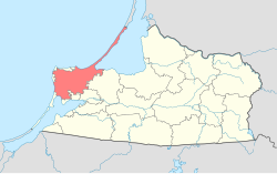
Baltiysky District is an administrative district (raion), one of the fifteen in Kaliningrad Oblast, Russia. As a municipal division, it is incorporated as Baltiysky Municipal District. Its administrative center is the town of Baltiysk, which accounts for 90.7% of the district's total population of 36,047 (2010 Census). It is the westernmost district in Russia, with the abandoned village of Narmeln being the westernmost point.
Svetlogorsky District is an administrative district (raion), one of the fifteen in Kaliningrad Oblast, Russia. As a municipal division, it is incorporated as Svetlogorsky Municipal District. It is located in the west of the oblast. The area of the district is 33.16 square kilometers (12.80 sq mi). Its administrative center is the town of Svetlogorsk. As of the 2010 Census, the total population of the district was 14,875, with the population of Svetlogorsk accounting for 72.4% of that number.