This article needs additional citations for verification .(June 2019) |

In Malta, most of the main roads are in the outskirts of the localities to connect one urban area with another urban area. The most important roads are those that connect the south of the island with the northern part, like Tal-Barrani Road, Aldo Moro Street in Marsa (the widest road in Malta) and Birkirkara Bypass (the busiest road in Malta)[ citation needed ].
Contents
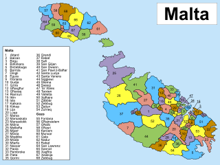
- Route Network in Malta
- Route 1
- Route 5
- Route 6
- Route 7
- Route 8
- Route 9
- Route 16
- Route 17
- Route 18
- Route 19
- Route 20
- Route 21
- Route 22
- Route 23
- Route 24
- Route 25
- Route 26
- Route 27
- Route 28
- Route 29
- Route 30
- Route 31
- Route 32
- Route 33
- Route 34
- Route 114
- Route 115
- Route 116
- Route 117
- Route 118
- Route 119
- Route 120
- Route 121
- Route 122
- Route 123
- Route 124
- Route 125
- Route 126
- Route 127
- Route 128
- Route 129
- From 130
- Route 131
- Route 132
- Route 133
- Route 134
- Route 135
- Route 137
- Route 138
- Route 139
- Route 140
- Route 141
- Route 142
- Route 143
- Route 144
- Route Network in Gozo
- Route 1 2
- Route 2
- Route 3
- Route 4
- Route 10
- Route 11
- Route 12
- Route 13
- Route 15
- Route 100
- Route 102
- Route 103
- Route 106
- Route 107
- Route 112
- Route 113
- Route 114 2
- Attard
- Balzan
- Birgu
- Birkirkara
- Birżebbuġa
- Bormla
- Dingli
- Fgura
- Floriana
- Gharghur
- Għaxaq
- Gudja
- Gżira
- Ħamrun
- Iklin
- Kalkara
- Kirkop
- Lija
- Luqa
- Marsa, Malta
- Marsaskala
- Marsaxlokk
- Mdina
- Mellieħa
- Mġarr
- Mosta
- Mqabba
- Msida
- Mtarfa
- Naxxar
- Paola, Malta
- Pembroke, Malta
- Pietà, Malta
- Qormi
- Qrendi
- Rabat, Malta
- San Ġiljan
- San Ġwann
- San Pawl il-Baħar
- Santa Luċija
- Santa Venera
- Siġġiewi
- Sliema
- Swieqi
- Ta' Xbiex
- Tarxien
- Valletta (Capital City)
- Żabbar
- Żebbuġ, Malta
- Żejtun
- Żurrieq
- Gozo
- Fontana, Gozo
- Għajnsielem
- Għarb
- Għasri
- Kerċem
- Munxar
- Nadur
- Qala
- San Lawrenz
- Sannat
- Victoria, Gozo (Gozo's capital)
- Xagħra
- Xewkija
- Żebbuġ, Gozo
- References
Traffic in Malta drives on the left. Car ownership in Malta is excessively high, given the islands' small size. In 1990, there were 182,254 registered cars, giving an automobile density of 582 per km2. [1] In 2009, the country had the fifth-highest number of vehicles per capita in the world, with 607 motor vehicles per 1,000 people. [2] At the end of March 2022, the number of licensed motor vehicles reached 414,669. [3]
Malta has 3,096 kilometres of road, 2,704 km (87.3%) of which are paved and 392 km are unpaved as of 2008. [4] The official road user guide for Malta is The Highway Code . [5]