Munxar

Last updated

Munxar
Il-Munxarin
Munxar parish church.jpg
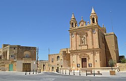
View of Munxar parish church and surroundings
Flag of Munxar.svg
Munxar coa.svg
Munxar in Malta.svg
Coordinates: 36°1′49″N14°14′7″E / 36.03028°N 14.23528°E / 36.03028; 14.23528
Country Flag of Malta.svg  Malta
Region Flag of Gozo.svg Gozo Region
District Gozo and Comino District
Borders Fontana, Kerċem, Sannat, Xewkija
Government
   Mayor Ludvik Azzopardi (PN)
Area
  Total2.8 km2 (1.1 sq mi)
Population
 (March 2023)
  Total110
  Density39/km2 (100/sq mi)
Demonym(s) Munxari (m), Munxarija (f), Munxarin (pl)
Time zone UTC+1 (CET)
  Summer (DST) UTC+2 (CEST)
Postal code
MXR
Dialing code 356
ISO 3166 code MT-36
Patron saint St. Paul
Website Official website

Munxar (Maltese : Il-Munxar) is an administrative unit of Malta, which lies on the southern side of island of Gozo. As of March 2014, its population was 1,454 people. [1]

Contents

Close by to this village, there is Xlendi Bay, a popular tourist resort engulfed in a fiord like inlet amongst high cliffs. Xlendi Bay is a small fishing village, but is also an ideal bathing and diving resort especially in summer. Otherwise, foreigners and locals enjoy the late spring and early autumn sunsets often captured by artists or keen photographers.

The parish church, a small baroque building built from the typical Maltese stone, is dedicated to St. Paul. It was built between 1914 and 1925 and was consecrated on 18 October 1925. Bishop Giuseppe Pace established it as a parish church on 12 December 1957. As a result, Munxar was the last village in Gozo to become an autonomous parish. The feast officially falls on 10 February which is also a national public holiday; however, the outside festivities are celebrated on the third Sunday of each May.

One of the people of note to have been born and lived in this village is Professor Joseph Aquilina.

History

The first records that were found recording Munxar as an area dates back to the sixteenth century when the area was named Monxiar, which means a bucksaw, taking its name from the two valleys running parallel from the village. From a sixteenth-century census, the village had a population of around 200 inhabitants. The first surnames recorded in the census were Attard, Barberi, Hagius, among a few others which suggests that these were the first Munxarin. In that time, Monxiar and Xlendi were part of the village of Sannat. At the time, the population of Xlendi was only 8 persons – the tower guardian and his family who lived in Xlendi tower.

Munxar playing field Munxar playing field.jpg
Munxar playing field

Remains of a megalithic temple were found in limits of Ta' Marżiena and also Roman remains were found in Xlendi valley. Geographically, Munxar has always formed part of the neighbouring village of Sannat. People of Munxar attended their spiritual needs at Saint Maragret parish at Sannat; however, historical facts and documented evidence points the existence of three other chapels, now completely demolished.

Late in the nineteenth century, the present parish priest of Sannat noticed the need for a small chapel for the spiritual need of the Munxarin, so a chapel was constructed in the site where the parish church now stands. In the following years, the chapel became too small since the village grew, and the rector of the chapel presented a petition to build a church to the bishop. The building of a new church was approved by the curia and on 2 February 1914 construction of a new church began on a site donated by two brothers and a sister known as 'Ta Katalla'. The church was finished on 19 February 1921. The church was dedicated to Saint Paul and later a statue of Saint Paul was made by Wistin Camilleri in 1933. Munxar church was made a parish on its own rights on 12 December 1957.

Zones in Munxar

Munxar Main Roads

Other Streets at Munxar

Related Research Articles

<span class="mw-page-title-main">Birkirkara</span> Local council in Central Region, Malta

Birkirkara is a city in the central region of Malta. It is the second most populous on the island, with 24,356 inhabitants as of 2020. The town consists of five autonomous parishes: Saint Helen, Saint Joseph the Worker, Our Lady of Mount Carmel, Saint Mary and San Gorg Preca. The city's motto is In hoc signo vinces, and its coat of arms is a plain red cross, surmounted by a crown.

<span class="mw-page-title-main">Balzan</span> Local council in Central Region, Malta

Balzan is a municipality in the Central Region of Malta, one of the so-called three villages, together with Attard and Lija. The village originally consisted of a group of small dwellings and farms but eventually grew, becoming a parish in the 17th century. As of 2021, the town registered a population of 4,774 inhabitants.

<span class="mw-page-title-main">Żurrieq</span> Local council in Southern Region, Malta

Żurrieq is a town in the Southern Region of Malta. It is one of the oldest towns in the country, and it has a population of 11,823 inhabitants as of March 2014. Żurrieq is one of the 10 parishes to be documented in 1436 and it is dedicated to Saint Catherine. The island of Filfla is administratively a part of the town. The town stretches from Nigret to Ħal Far. In old times the town was had a border with Żejtun. The village of Qrendi used to be part of the parish of Żurrieq until 1618 when it was made into its own parish.

<span class="mw-page-title-main">Safi, Malta</span> Local council in Southern Region, Malta

Safi is a village in the Southern Region of Malta, bordering Żurrieq and Kirkop. It has a population of 2,126 people as of March 2014.

<span class="mw-page-title-main">San Ġwann</span> Local council in Central Region, Malta

San Ġwann is a town in the Central Region of Malta, with a population of 14,244 as of 2021. Previous to its separate administration the town used to form part of two separate localities being Birkirkara and St. Julian's.

<span class="mw-page-title-main">Gudja</span> Local council in Southern Region, Malta

Gudja is a village in the Southern Region of Malta, with a population of 3,148 as of March 2017. The village is located on high grounds, south of Valletta. It is administered by the Gudja Local Council. A number of schools, clubs, public gardens and recreations places are found around the village.

<span class="mw-page-title-main">Għargħur</span> Local council in Northern Region, Malta

Għargħur is a village in the Northern Region of Malta. It is situated on a hilltop between two valleys, and it has a population of 2,768 as of March 2014.

<span class="mw-page-title-main">Għasri</span> Local council in Gozo Region, Malta

Għasri is an administrative unit of Malta, in the western part of the island of Gozo, with a population of 525 people. By population, it is the smallest village in Gozo after San Lawrenz, and the third-smallest in the Maltese Islands, after Bidnija and Mdina. Għasri, however, has a relatively large area.

<span class="mw-page-title-main">Għajnsielem</span> Local council in Gozo Region, Malta

Għajnsielem, meaning "Peaceful Spring", is a municipality on the southeastern coast of the island of Gozo in Malta, including the entire island of Comino. It has a population of 3,200 residents, and is the first Gozitan village that greets the visitor on leaving Mġarr Harbour towards the Gozitan heartland. Its name originated from the water spring, around which in 1700, Grandmaster Perellos built an arcade containing public wash basins and fresh water spouts. Attractions include Lourdes Chapel with its sharp steeple and underlying niche of Our Lady of Lourdes, Fort Chambray and the towering of Ghajnsielem Parish Church.

<span class="mw-page-title-main">Qala, Malta</span> Local council in Gozo Region, Malta

Qala is an administrative unit of Malta, on the island of Gozo, with a population of 1,929 as of September 2019. Nearby is Ħondoq ir-Rummien, a coastline with salt pans and caves.

<span class="mw-page-title-main">San Lawrenz</span> Local council in Gozo Region, Malta

San Lawrenz is an administrative unit of Malta, on the island of Gozo. Its name is derived from Lawrence of Rome who is the patron saint for the locality. It has a population of 748, as of March 2014.

<span class="mw-page-title-main">Sannat</span> Local council in Gozo Region, Malta

Sannat is an administrative unit of Malta, on the island of Gozo, with a population of 2,117 people. Ta' Sannat is in the south of Gozo, popular for its very high cliffs, ancient cart ruts, temples and dolmens, and rich fauna and flora. In 1951 The Duchess of Edinburgh of the United Kingdom visited a house called "The Lace house" located in a small square in Ta' Sannat called "Pjazza Tax-Xelina".

Xlendi is an urban village in Malta situated in the south west of the island of Gozo. It is surrounded by the villages of Munxar, Fontana and Kerċem. The village is administered by Munxar, but has its own coat of arms and motto. From March 2010, Xlendi has had its own 5-person "mini council" responsible for the main activities of the area.

<span class="mw-page-title-main">Districts of Malta</span>

Malta is for non-local government purposes divided into districts as opposed to the local government localities. The three main types of such districts – statistical, electoral at national level, and policing – have no mainstream administrative effect as the local councils form the first-tier – moreover only administrative tier – divisions of the country.

<span class="mw-page-title-main">Coastline of Malta</span>

The coastline of Malta consists of bays, sandy beaches, creeks, harbours, small villages, cities, cliffs, valleys, and other interesting sites. Here, there is a list of these different natural features that are found around the coast of Malta.

<span class="mw-page-title-main">Roads in Malta</span> Overview of the various roads in Malta

In Malta most of the main roads are in the outskirts of the localities to connect one urban area with another urban area. The most important roads are those that connect the south of the island with the northern part, like Tal-Barrani Road, Aldo Moro Street in Marsa and Birkirkara Bypass.

References

  1. "Estimated Population by Locality 31st March, 2014". Government of Malta. 16 May 2014. Archived from the original on 21 June 2015.