San Lawrenz | |
|---|---|
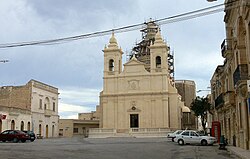 San Lawrenz parish church | |
 Flag  Coat of arms | |
 | |
| Coordinates: 36°3′18″N14°12′15″E / 36.05500°N 14.20417°E | |
| Country | |
| Region | |
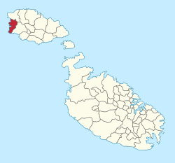
| District | Gozo and Comino District |
| Borders | Kerċem, Għarb |
| Government | |
| • Mayor | Noel Formosa (PN) |
| Area | |
• Total | 3.6 km2 (1.4 sq mi) |
| Population (March 2014) | |
• Total | 748 |
| • Density | 210/km2 (540/sq mi) |
| Demonym(s) | Lawrenzjan (m), Lawrenzjana (f), Lawrenzjani (pl) |
| Time zone | UTC+1 (CET) |
| • Summer (DST) | UTC+2 (CEST) |
| Postal code | SLZ |
| Dialing code | 356 |
| ISO 3166 code | MT-50 |
| Patron saint | St. Lawrence |
| Day of festa | 10 August |
| Website | Official website |

San Lawrenz is an administrative unit of Malta, on the island of Gozo. Its name is derived from Lawrence of Rome who is the patron saint for the locality. It has a population of 748, as of March 2014.
Contents
The Dwejra nature reserve is administratively part of the town. Prominent in the reserve is the Fungus Rock, and formerly also the Azure Window landmark before its collapse on March 8, 2017. [1]