Sannat Ta' Sannat | |
|---|---|
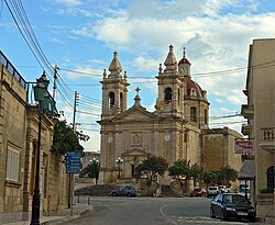 Sannat parish church | |
 Flag  Coat of arms | |
 | |
| Coordinates: 36°1′28″N14°14′45″E / 36.02444°N 14.24583°E | |
| Country | |
| Region | |
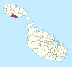
| District | Gozo and Comino District |
| Borders | Għajnsielem, Munxar, Xewkija |
| Government | |
| • Mayor | Vella Philip (PL) |
| Area | |
• Total | 3.8 km2 (1.5 sq mi) |
| Population (March 2014) | |
• Total | 2,117 |
| • Density | 560/km2 (1,400/sq mi) |
| Demonym(s) | Sannati (m), Sannatija (f), Sannatin (pl) |
| Time zone | UTC+1 (CET) |
| • Summer (DST) | UTC+2 (CEST) |
| Postal code | SNT |
| Dialing code | 356 |
| ISO 3166 code | MT-52 |
| Patron saint | St. Margaret |
| Website | Official website |
Sannat (Maltese : Ta' Sannat) is an administrative unit of Malta, on the island of Gozo, with a population of 2,117 people (March 2014). [1] Ta' Sannat is in the south of Gozo, popular for its very high cliffs, ancient cart ruts, temples and dolmens, and rich fauna and flora. In 1951 The Duchess of Edinburgh (who became Queen Elizabeth II) of the United Kingdom visited a house called "The Lace house" located in a small square in Ta' Sannat called "Pjazza Tax-Xelina".
