Golnice

Last updated
Golnice
Village
POL Village haus in Golnice.JPG
Poland adm location map.svg
Red pog.svg
Golnice
Location of Golnice
Coordinates: 51°20′56″N15°35′07″E / 51.34889°N 15.58528°E / 51.34889; 15.58528 Coordinates: 51°20′56″N15°35′07″E / 51.34889°N 15.58528°E / 51.34889; 15.58528
Country Flag of Poland.svg Poland
Voivodeship Lower Silesian
County Bolesławiec
Gmina Bolesławiec
Population 240
Time zone CET (UTC+1)
  Summer (DST) CEST (UTC+2)

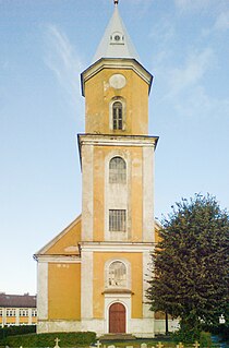
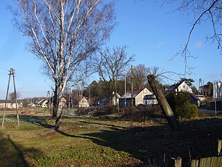
Golnice [ɡɔlˈnit͡sɛ] (German : Groß Gollnisch) is a village in the administrative district of Gmina Bolesławiec, within Bolesławiec County, Lower Silesian Voivodeship, in south-western Poland. [1] It lies approximately 10 km (6 mi) north of Bolesławiec, and 105 km (65 mi) west of the regional capital Wrocław.

German language West Germanic language

German is a West Germanic language that is mainly spoken in Central Europe. It is the most widely spoken and official or co-official language in Germany, Austria, Switzerland, South Tyrol (Italy), the German-speaking Community of Belgium, and Liechtenstein. It is also one of the three official languages of Luxembourg and a co-official language in the Opole Voivodeship in Poland. The languages which are most similar to German are the other members of the West Germanic language branch: Afrikaans, Dutch, English, the Frisian languages, Low German/Low Saxon, Luxembourgish, and Yiddish. There are also strong similarities in vocabulary with Danish, Norwegian and Swedish, although those belong to the North Germanic group. German is the second most widely spoken Germanic language, after English.

Village Small clustered human settlement smaller than a town

A village is a clustered human settlement or community, larger than a hamlet but smaller than a town, with a population ranging from a few hundred to a few thousand. Though villages are often located in rural areas, the term urban village is also applied to certain urban neighborhoods. Villages are normally permanent, with fixed dwellings; however, transient villages can occur. Further, the dwellings of a village are fairly close to one another, not scattered broadly over the landscape, as a dispersed settlement.

Administrative division A territorial entity for administration purposes

An administrative division, unit, entity, area or region, also referred to as a subnational entity, statoid, constituent unit, or country subdivision, is a portion of a country or other region delineated for the purpose of administration. Administrative divisions are granted a certain degree of autonomy and are usually required to manage themselves through their own local governments. Countries are divided up into these smaller units to make managing their land and the affairs of their people easier. A country may be divided into provinces, which, in turn, may be divided in whole or in part into municipalities.

The village has a population of 240.

Related Research Articles

Brzeźnik, Lower Silesian Voivodeship Village in Lower Silesian, Poland

Brzeźnik is a village in the administrative district of Gmina Bolesławiec, within Bolesławiec County, Lower Silesian Voivodeship, in south-western Poland. It lies approximately 8 km (5 mi) west of Bolesławiec, and 111 km (69 mi) west of the regional capital Wrocław.

Bolesławice, Bolesławiec County Village in Lower Silesian, Poland

Bolesławice is a village in the administrative district of Gmina Bolesławiec, within Bolesławiec County, Lower Silesian Voivodeship, in south-western Poland.

Bożejowice Village in Lower Silesian, Poland

Bożejowice is a village in the administrative district of Gmina Bolesławiec, within Bolesławiec County, Lower Silesian Voivodeship, in south-western Poland.

Chościszowice Village in Lower Silesian, Poland

Chościszowice is a village in the administrative district of Gmina Bolesławiec, within Bolesławiec County, Lower Silesian Voivodeship, in south-western Poland.

Dąbrowa Bolesławiecka Village in Lower Silesian, Poland

Dąbrowa Bolesławiecka is a village in the administrative district of Gmina Bolesławiec, within Bolesławiec County, Lower Silesian Voivodeship, in south-western Poland. It lies approximately 7 km (4 mi) north of Bolesławiec, and 105 km (65 mi) west of the regional capital Wrocław.

Kozłów, Bolesławiec County Village in Lower Silesian, Poland

Kozłów is a village in the administrative district of Gmina Bolesławiec, within Bolesławiec County, Lower Silesian Voivodeship, in south-western Poland. Prior to 1945 it was in Germany.

Kraszowice Village in Lower Silesian, Poland

Kraszowice is a village in the administrative district of Gmina Bolesławiec, within Bolesławiec County, Lower Silesian Voivodeship, in south-western Poland. Prior to 1945 it was in Germany.

Kraśnik Dolny Village in Lower Silesian, Poland

Kraśnik Dolny is a village in the administrative district of Gmina Bolesławiec, within Bolesławiec County, Lower Silesian Voivodeship, in south-western Poland. Prior to 1945 it was in Germany.

Kraśnik Górny Village in Lower Silesian, Poland

Kraśnik Górny is a village in the administrative district of Gmina Bolesławiec, within Bolesławiec County, Lower Silesian Voivodeship, in south-western Poland. Prior to 1945 it was in Germany.

Krępnica Village in Lower Silesian, Poland

Krępnica is a village in the administrative district of Gmina Bolesławiec, within Bolesławiec County, Lower Silesian Voivodeship, in south-western Poland. Prior to 1945 it was in Germany.

Kruszyn, Lower Silesian Voivodeship Village in Lower Silesian, Poland

Kruszyn is a village in the administrative district of Gmina Bolesławiec, within Bolesławiec County, Lower Silesian Voivodeship, in south-western Poland. Prior to 1945 it was in Germany.

Lipiany, Lower Silesian Voivodeship Village in Lower Silesian, Poland

Lipiany is a village in the administrative district of Gmina Bolesławiec, within Bolesławiec County, Lower Silesian Voivodeship, in south-western Poland. Prior to 1945 it was in Germany and after the Potsdam Agreement the ethnic German population was expelled and their property confiscated.

Łaziska, Lower Silesian Voivodeship Village in Lower Silesian, Poland

Łaziska is a village in the administrative district of Gmina Bolesławiec, within Bolesławiec County, Lower Silesian Voivodeship, in south-western Poland. Prior to 1945 it was in Germany and until then the official German place name was Looswitz.

Łąka, Lower Silesian Voivodeship Village in Lower Silesian, Poland

Łąka is a village in the administrative district of Gmina Bolesławiec, within Bolesławiec County, Lower Silesian Voivodeship, in south-western Poland. Prior to 1945 it was in Germany.

Mierzwin, Lower Silesian Voivodeship Village in Lower Silesian, Poland

Mierzwin is a village in the administrative district of Gmina Bolesławiec, within Bolesławiec County, Lower Silesian Voivodeship, in south-western Poland. Prior to 1945 it was in Germany.

Nowe Jaroszowice Village in Lower Silesian, Poland

Nowe Jaroszowice is a village in the administrative district of Gmina Bolesławiec, within Bolesławiec County, Lower Silesian Voivodeship, in south-western Poland. Prior to 1945 it was in Germany.

Stara Oleszna Village in Lower Silesian, Poland

Stara Oleszna is a village in the administrative district of Gmina Bolesławiec, within Bolesławiec County, Lower Silesian Voivodeship, in south-western Poland. Prior to 1945 it was in Germany.

Stare Jaroszowice Village in Lower Silesian, Poland

Stare Jaroszowice is a village in the administrative district of Gmina Bolesławiec, within Bolesławiec County, Lower Silesian Voivodeship, in south-western Poland. Prior to 1945 it was in Germany.

Trzebień, Lower Silesian Voivodeship Village in Lower Silesian, Poland

Trzebień is a village in the administrative district of Gmina Bolesławiec, within Bolesławiec County, Lower Silesian Voivodeship, in south-western Poland. It lies approximately 14 km (9 mi) north of Bolesławiec, and 105 km (65 mi) west of the regional capital Wrocław.

Gmina Bolesławiec is a rural gmina in Wieruszów County, Łódź Voivodeship, in central Poland. Its seat is the village of Bolesławiec, which lies approximately 12 kilometres (7 mi) south of Wieruszów and 110 km (68 mi) south-west of the regional capital Łódź.

References