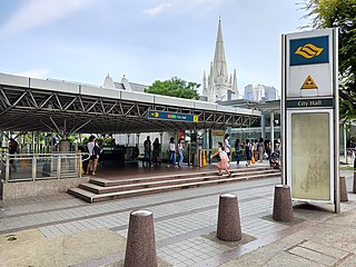
City Hall MRT station is an underground Singapore Mass Rapid Transit (MRT) interchange station on the North–South line (NSL) and East–West line (EWL). Situated in the Downtown Core district, it is underneath Stamford Road near the road junctions with North Bridge Road and St Andrew's Road. The station is near landmarks such as the former City Hall, Raffles City, the Padang, St Andrew's Cathedral and the Cenotaph.

Raffles Place MRT station is an underground Mass Rapid Transit (MRT) interchange station on the North South Line (NSL) and East West Line (EWL) in Singapore. Located in the Downtown Core, the station is underneath Raffles Place south of the Singapore River. The station serves various landmarks including The Fullerton Hotel, Merlion Park and the Asian Civilisations Museum and various commercial buildings such as One Raffles Place and OCBC Centre.

Outram Park MRT station is an underground Mass Rapid Transit (MRT) interchange station in Singapore. The station is on the East–West, North East and Thomson–East Coast lines, and is located near the junction of Outram Road, Eu Tong Sen Street and New Bridge Road on the boundary of Bukit Merah and Outram planning areas. It is the closest MRT station to Singapore General Hospital, the Police Cantonment Complex, Outram Community Hospital and the Health Promotion Board. The station was included in the early plans of the MRT network in 1982; it was constructed as part of the Phase I MRT segment from Novena, and was completed in December 1987.

Boon Lay MRT station is a Mass Rapid Transit (MRT) station on the East West line (EWL) in Jurong West, Singapore. Situated along Boon Lay Way, the station is integrated with the Boon Lay Bus Interchange and Jurong Point as part of the Boon Lay Integrated Transport Hub. Other landmarks surrounding the station include the SAFRA Clubhouse and Jurong West Public Library.

Marina Bay MRT station is an underground Mass Rapid Transit (MRT) interchange station on the North South (NSL), Circle (CCL) and Thomson–East Coast (TEL) lines in Singapore. Located in the Downtown Core district near Marina Bay, the station serves the Marina One Residences, Marina Bay Suites and the Marina Bay Financial Centre.

The Pan Island Expressway is the oldest and longest expressway in Singapore. It is also Singapore's longest road. The expressway runs from the East Coast Parkway near Changi Airport in the east to Tuas in the west and has a total length of 42.8 kilometres (26.6 mi).
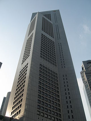
AXA Tower, also known as 8 Shenton Way and formerly The Treasury and Temasek Tower, was the 16th-tallest skyscraper in the city of Singapore, at 234.7 m (770 ft), and the tallest cylindrical building in the world. In 2023, it became the tallest building to ever be voluntarily demolished.

United Overseas Bank Plaza is a commercial complex that consists of twin tower late-modernist skyscrapers in Singapore. At completion, UOB Plaza One was one of the three tallest in the country, sharing the title with the OUB Centre and Republic Plaza; it is now the second tallest since the completion of Tanjong Pagar Centre in 2016.

Republic Plaza is a skyscraper in Downtown Core, Singapore. It comprises two towers and a 10-storey podium. The first tower, Republic Plaza I, has 66 floors and a height of 280 metres (920 ft), and has a varying octagonal-cross section, while its interior allows for flexible space usage by tenants. The second tower, Republic Plaza II, is 23 stories tall, while the podium contains a three-floor retail area.

Orchard MRT station is an underground Mass Rapid Transit (MRT) interchange station in Singapore, on the North South (NSL) and Thomson–East Coast (TEL) lines. Situated along Orchard Boulevard and underneath ION Orchard, the station serves various commercial and retail developments of the Orchard Road shopping district, including Liat Towers, Ngee Ann City, Wheelock Place, Wisma Atria and Shaw House, among others.
Bugis MRT station is an underground Mass Rapid Transit (MRT) interchange station on the East–West (EWL) and Downtown (DTL) lines. Situated in Bugis, Singapore, the station is underneath the junction of Rochor Road and Victoria Street. Various developments surrounding the station include Bugis Junction, Raffles Hospital and the National Library. The station is also close to Kampung Glam.

Tanjong Pagar MRT station is an underground Mass Rapid Transit (MRT) station on the East West line located at Maxwell Road between the junctions of Peck Seah Street and Cecil Street in Downtown Core, Singapore. The station was built in the 1980s, and was opened in December 1987. Taking its name from Tanjong Pagar Road, which is located near the station, it is located near Tanjong Pagar Complex, the AXA Tower and International Plaza.

The Singapore Improvement Trust (SIT) is a former government organisation that was responsible for urban planning and urban renewal in Singapore. Formally established in 1927 under the Singapore Improvement Ordinance, it was modelled after similar organisations in India. The SIT initially carried out back lane improvement schemes and marking out unsanitary buildings for demolition, but began constructing public housing from 1935. After 1945, the SIT initially focused its efforts on the repair of its residential developments. It resumed constructing public housing in 1947 but was unable to keep up with demand. The SIT was also involved in the development of a "Master Plan", which set out Singapore's developmental direction, from 1952 to 1958. In the late 1950s, plans were set out to replace the SIT with two departments—housing and planning—culminating in two bills that were passed in 1959. With the establishment of the successor organisations by the government of Singapore, the Housing and Development Authority and the Planning Authority, in 1960, the SIT was dissolved.

Nicoll Highway is a major arterial road in Singapore which links the junctions of Guillemard Road, Sims Way and Mountbatten Road in Kallang to the junctions of Esplanade Drive, Raffles Avenue and Stamford Road in the city. En route, it passes through the areas of Kallang, Kampong Glam and Marina Centre.

The Singapore Conference Hall is a multipurpose building located in Shenton Way of Singapore. It was gazetted as a national monument on 28 December 2010.
Swan & Maclaren Architects is a Singaporean architectural and industrial design firm. One of the oldest architectural firms in the country, it was formerly known as Swan & Maclaren and Swan & Lermit, and was one of the most prominent architectural firms in Singapore when it was a crown colony during the early 20th century. The firm has designed numerous iconic heritage buildings in Singapore as well as Malaysia.

The Bank of China Building is a development consisting of two skyscrapers located in the central business district of Singapore. It is located on 4 Battery Road, adjacent to 6 Battery Road, Maybank Tower, and roughly 100 metres from the Fullerton Hotel. The Tower serves as the headquarters for the Bank of China.
Van Kleef Aquarium was an oceanarium located along River Valley Road, at the foot of Fort Canning Hill, in Singapore. Fully air-conditioned, the aquarium had 6,500 animals at the time of opening, which were housed in freshwater, seawater, and swamp tanks respectively.
One Raffles Place is a skyscraper in Downtown Core, Singapore. The development comprises two towers and a podium. The 280 m (920 ft) tall Tower One and the 38-storey Tower Two house offices, while the podium contains retail space. Initially conceived in the late 1970s as Overseas Union Bank Centre, the headquarters of Overseas Union Bank (OUB), work on the building began in 1981, while construction of the superstructure subsequently commenced in October 1984. Costing S$486 million to build, OUB Centre opened in two phases in June and December 1986, and 90% of its office space was occupied upon opening. At the time of its completion, The Business Times claimed that the complex's tower was the tallest in the world outside the United States.

Shenton Way Bus Terminal is a bus terminal in Singapore. It is located along its namesake road, Shenton Way, in Downtown Core. The first iteration of the bus terminal was opened on 20 June 1987, before being relocated twice in order to make way for other development works. The bus terminal was first moved to Palmer Road in 2010, before being shifted to its present location along Shenton Way in 2017.