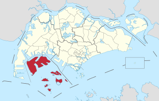
Jurong is a major geographical region located at the south-westernmost point of the West Region of Singapore. Although mostly vaguely defined, the region's extent roughly covers the planning areas of Jurong East, Jurong West, Boon Lay, and Pioneer, along with Jurong Island in the Western Islands cluster and the southernmost portions of the Western Water Catchment. Should it be described at its greatest historical extent, the region can also include present-day Bukit Batok and Tuas.

Jurong Island is an island located to the southwest of the main island of Singapore. It was formed from the amalgamation of seven offshore islands, the islands of Pulau Ayer Chawan, Pulau Ayer Merbau, Pulau Merlimau, Pulau Pesek, Pulau Pesek Kechil, Pulau Sakra, Pulau Seraya, Pulau Meskol, Pulau Mesemut Laut, Pulau Mesemut Darat and Anak Pulau. This was done through Singapore's land reclamation efforts. Land reclamation on Jurong Island was completed on 25 September 2009, 20 years earlier than scheduled. Pulau Buaya was joined to Jurong Island via reclamation in 2010. Jurong Island forms a land area of about 32 km2 (12 sq mi) from an initial area of less than 10 km2 (4 sq mi), and is the largest of Singapore's outlying islands.

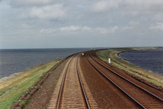
A causeway is a track, road or railway on the upper point of an embankment across "a low, or wet place, or piece of water". It can be constructed of earth, masonry, wood, or concrete. One of the earliest known wooden causeways is the Sweet Track in the Somerset Levels, England, which dates from the Neolithic age. Timber causeways may also be described as both boardwalks and bridges.

The expressways of Singapore are special roads that allow motorists to travel quickly from one urban area to another. Construction of the system was authorized when construction of the Pan Island Expressway began in 1962. All of them are dual carriageways with grade-separated access. They usually have three to four lanes in each direction, although there are two-lane carriageways at many expressway intersections and five-lane carriageways in some places. There are currently ten expressways and studies about the feasibility of more are ongoing.

The East Coast Parkway is an expressway that runs along the southeastern coast of Singapore. It is approximately 16 kilometres (9.9 mi) in length. As of July 2022, it is Singapore's third-longest expressway.

Singapore is a city-state and island country in maritime Southeast Asia, located at the end of the Malayan Peninsula between Malaysia and Indonesia as well as the Straits of Malacca and the South China Sea. It is heavily compact and urbanised. As of 2023, Singapore has a total land area of approximately 750 square kilometres (290 sq mi). Singapore is separated from Indonesia by the Singapore Strait and from Malaysia by the Straits of Johor.

The Pan Island Expressway is the oldest and longest expressway in Singapore. It is also Singapore's longest road. The expressway runs from the East Coast Parkway near Changi Airport in the east to Tuas in the west and has a total length of 42.8 kilometres.

The Bukit Timah Expressway (BKE) is a highway in Singapore that starts at the Pan Island Expressway in Bukit Timah and travels north to the Woodlands Checkpoint and the Johor–Singapore Causeway in Woodlands.
The Jurong Police Division is one of the seven land divisions of the Singapore Police Force. Jurong Division first came into existence as the ‘Rural West’ Division on 24 Sep 1965 and operated from a standalone building located at Bukit Panjang. As the communities in the west grew, police posts were built in Ama Keng, Mandai and Kranji.

Jurong East Bus Interchange is a bus interchange located in Jurong East, Singapore. An open-air single-level bus terminal, it is connected to the adjacent Jurong East MRT station via a link bridge.

The Southern Integrated Gateway refers to a complex at Bukit Chagar, Johor Bahru, Johor, Malaysia incorporating the city's main railway station, JB Sentral, and a customs, immigration, and quarantine complex (CIQ), the Sultan Iskandar Building, named after Almarhum Sultan Iskandar ibni Almarhum Sultan Ismail of Johor.

The South West Community Development Council is one of five Community Development Councils (CDCs) set up across the Republic of Singapore to aid in local administration of governmental policies and schemes. They are funded in part by the government although they are free to engage in fund-raising activities.

The Western Islands is a planning area located within the West Region of Singapore. It comprises a collection of islands located in the south-western waters of Singapore, namely Jurong Island, Pulau Bukom, and Sudong Islands.
Wenya is a subzone of Jurong West, Singapore.

The Sultan Iskandar Building is a customs, immigration and quarantine (CIQ) complex in Johor Bahru, Johor, Malaysia. Located at the northern end of the Johor–Singapore Causeway, it is one of two land ports of entry to Malaysia on the Malaysia–Singapore border.
Pulau Samulun is an offshore island in Jurong Industrial Estate, Singapore. It is separated from mainland Singapore by Selat Samulun. It is only less than a kilometre away from Singapore mainland. Jurong Shipyard is located in Pulau Samulun and it also houses a food centre that caters to the workers working there. Samulun is from "sembulun" a tribe of Orang Laut who once lived here.

Jurong Town Hall Road is a road in Jurong East, Singapore that connects the Pan Island Expressway and West Coast Road.
The Jurong railway line is a former railway line located in Singapore. Stretching a total of 12 miles (19 km) from Bukit Timah to the Jurong industrial estate, the line consisted of a 9 miles (14 km) main line and three branches. The line was initially planned as part of the Jurong industrial estate by the Singapore government, to connect the industrial estate with Malaya and to facilitate the transfer of goods between Malaya and Jurong. A $6 million loan was given to the Malayan Railway for its construction, which was carried out by the railway and the Economic Development Board, and construction of the line took place between September 1963 and November 1965, with the first train services commencing in the same month. The line was then officially opened on 4 March 1966. However, the line's potential was limited by Singapore's separation from Malaysia in 1965, with 128,000 tons of freight transported on the line in 1974, and the line eventually closed in the 1990s. Portions of the line remain in place, some of which have become popular among explorers and wildlife enthusiasts.


