| Doi Mae Tho | |
|---|---|
| ดอยแม่โถ | |
 Doi Mae Tho | |
| Highest point | |
| Elevation | 2,031 m (6,663 ft) |
| Listing | List of mountains in Thailand |
| Coordinates | 19°00′06″N99°24′20″E / 19.00167°N 99.40556°E Coordinates: 19°00′06″N99°24′20″E / 19.00167°N 99.40556°E |
| Geography | |
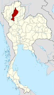
| Location | Chiang Rai Province |
| Parent range | Khun Tan Range |
| Climbing | |
| First ascent | unknown |
| Easiest route | drive, then hike |
Doi Mae Tho (Thai : ดอยแม่โถ), also known as Doi Langka Luang (ดอยลังกาหลวง) or Doi Lang Ka (ดอยลังกา), [1] is a mountain in Thailand, part of the Khun Tan Range.

Thai, Central Thai or Ayutthaya or Siamese, is the sole official and national language of Thailand and the first language of the Central Thai people and vast majority of Thai of Chinese origin. It is a member of the Tai group of the Kra–Dai language family. Over half of Thai vocabulary is derived from or borrowed from Pali, Sanskrit, Mon and Old Khmer. It is a tonal and analytic language, similar to Chinese and Vietnamese.

Thailand, officially the Kingdom of Thailand and formerly known as Siam, is a country at the center of the Southeast Asian Indochinese peninsula composed of 76 provinces. At 513,120 km2 (198,120 sq mi) and over 68 million people, Thailand is the world's 50th largest country by total area and the 21st-most-populous country. The capital and largest city is Bangkok, a special administrative area. Thailand is bordered to the north by Myanmar and Laos, to the east by Laos and Cambodia, to the south by the Gulf of Thailand and Malaysia, and to the west by the Andaman Sea and the southern extremity of Myanmar. Its maritime boundaries include Vietnam in the Gulf of Thailand to the southeast, and Indonesia and India on the Andaman Sea to the southwest. Although nominally a constitutional monarchy and parliamentary democracy, the most recent coup in 2014 established a de facto military dictatorship.

The Khun Tan Range is a mountain range that occupies a central position in Northern Thailand. Most of the range is located in Chiang Mai, western Chiang Rai, Lampang and Lamphun Provinces.
Contents
The mountain rises in the SW of Wiang Pa Pao District, Chiang Rai Province, near the point where the limit of this province meets with Chiang Mai and Lampang Provinces. With a height of 2,031 metres it is the highest point of the Khun Tan Range. [2]
Wiang Pa Pao is the southwesternmost district (amphoe) of Chiang Rai Province, northern Thailand.

Jiang Hai or Chiang Rai is the northernmost province of Thailand. It is bordered by the Shan State of Myanmar to the north, Bokeo Province of Laos to the east, Phayao to the south, Lampang to the southwest, and Chiang Mai to the west.

Jiang Mai or Chiang Mai is the second-largest province (changwat) of Thailand. It is in the country's north. It is bordered by Chiang Rai to the northeast, Lampang and Lamphun to the south, Tak to the southwest, Mae Hong Son to the west, and Shan State of Burma to the north. The capital, Chiang Mai, is 685 km north of Bangkok.
Its summit is located less than 8 km to the SE of Route 118 between Chiang Mai and Chiang Rai.