Outline of Thailand

Last updated
The location of Thailand LocationThailand.svg
The location of Thailand
An enlargeable map of the Kingdom of Thailand Un-thailand.png
An enlargeable map of the Kingdom of Thailand

The following outline is an overview of and topical guide to Thailand.

Contents

Thailand is a country at the centre of the Indochina peninsula in Southeast Asia, known as Siam until 1939. As of 2023 Thailand is a monarchy governed by a military junta that took power in May 2014. Although a constitutional system was established in 1932, the monarchy and military have continued to intervene periodically in politics. Thailand experienced rapid economic growth between 1985 and 1996, becoming a newly industrialized country and a major exporter. Manufacturing, agriculture, and tourism are leading sectors of the economy. Among the ten ASEAN countries, Thailand ranks second in quality of life and the country's HDI had been rated as "high". Its large population and growing economic influence have made it a middle power in the region and around the world.

Tai groups and people who speak Tai are the majority population in Thailand, with Tai-Lao speakers making up 25% of the population. The heartland of Thailand is the Chao Phraya River Valley, where the original inhabitants were Mon-speaking people. The Mon people are now a minority, and the Mon language is endangered. The valley later gained control over Eastern Thailand as well, known as the Korat Plateau. This area is not mountainous, as its name would suggest. Although the people of this area have largely adopted Thai culture, there is still a mixture of many Tai-Kadai, Khmer, and Cambodian speakers. Northern Thailand is mountainous and holds many minority groups: "hill tribes." Another mountainous region is the Malay Peninsula, where the 3rd largest population of Malay people live. Many in this area speak Mon-related languages.

General reference

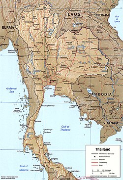
An enlargeable relief map of Thailand Thailand 2002 CIA map.jpg
An enlargeable relief map of Thailand

Geography of Thailand

An enlargeable topographic map of Thailand Thailand Topography.png
An enlargeable topographic map of Thailand

Geography of Thailand

Flag of Myanmar.svg  Burma 1,800 km
Flag of Laos.svg  Laos 1,754 km
Flag of Cambodia.svg  Cambodia 803 km
Flag of Malaysia.svg  Malaysia 506 km
  • Coastline: 3,219 km

Environment of Thailand

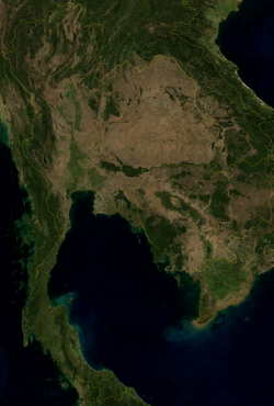
An enlargeable satellite image of Thailand Thailand BMNG.png
An enlargeable satellite image of Thailand

Natural geographic features of Thailand

Mekong River System Mekong system color.png
Mekong River System
Mahanakhon, once the tallest building in Thailand Maha Nakhon Building from street.jpg
Mahanakhon, once the tallest building in Thailand

Regions of Thailand

Regions of Thailand

Ecoregions of Thailand

Ecoregions in Thailand

Administrative divisions of Thailand

Administrative divisions of Thailand

Provinces of Thailand

Thailand is divided into 76 provinces (จังหวัด, changwat) and the metropolitan municipality Bangkok (กรุงเทพมหานคร, Krung Thep Maha Nakhon).

Map showing the 76 provinces and 1 metropolitan municipality (Bangkok) of Thailand Thailand provinces six regions.png
Map showing the 76 provinces and 1 metropolitan municipality (Bangkok) of Thailand
A chedi built in Srivijaya period, Amphoe Chaiya, Surat Thani Province Wat phra borom that chaiya suratthani4.jpg
A chedi built in Srivijaya period, Amphoe Chaiya, Surat Thani Province
Northern
  1. Chiang Mai (เชียงใหม่)
  2. Chiang Rai (เชียงราย)
  3. Lampang (ลำปาง)
  4. Lamphun (ลำพูน)
  5. Mae Hong Son (แม่ฮ่องสอน)
  6. Nan (น่าน)
  7. Phayao (พะเยา)
  8. Phrae (แพร่)
  9. Uttaradit (อุตรดิตถ์)

West

  1. Kanchanaburi (กาญจนบุรี)
  2. Phetchaburi (เพชรบุรี)
  3. Prachuap Khiri Khan (ประจวบคีรีขันธ์)
  4. Ratchaburi (ราชบุรี)
  5. Tak (ตาก)

Isan

  1. Amnat Charoen (อำนาจเจริญ)
  2. Bueng Kan (บึงกาฬ)
  3. Buri Ram (บุรีรัมย์)
  4. Chaiyaphum (ชัยภูมิ)
  5. Kalasin (กาฬสินธุ์)
  6. Khon Kaen (ขอนแก่น)
  7. Loei (เลย)
  8. Maha Sarakham (มหาสารคาม)
  9. Mukdahan (มุกดาหาร)
  10. Nakhon Phanom (นครพนม)
  11. Nakhon Ratchasima (นครราชสีมา)
  12. Nong Bua Lamphu (หนองบัวลำภู)
  13. Nong Khai (หนองคาย)
  14. Roi Et (ร้อยเอ็ด)
  15. Sakon Nakhon (สกลนคร)
  16. Si Sa Ket (ศรีสะเกษ)
  17. Surin (สุรินทร์)
  18. Ubon Ratchathani (อุบลราชธานี)
  19. Udon Thani (อุดรธานี)
  20. Yasothon (ยโสธร)

Central

  1. Ang Thong (อ่างทอง)
  2. Phra Nakhon Si Ayutthaya Province (พระนครศรีอยุธยา)
  3. Bangkok (Krung Thep Maha Nakhon), Special Governed District of (กรุงเทพ ฯ)
  4. Chai Nat (ชัยนาท)
  5. Kamphaeng Phet (กำแพงเพชร)
  6. Lopburi (ลพบุรี)
  7. Nakhon Nayok (นครนายก)
  8. Nakhon Pathom (นครปฐม)
  9. Nakhon Sawan (นครสวรรค์)
  10. Nonthaburi (นนทบุรี)
  11. Pathum Thani (ปทุมธานี)
  12. Phetchabun (เพชรบูรณ์)
  13. Phichit (พิจิตร)
  14. Phitsanulok (พิษณุโลก)
  15. Sukhothai (สุโขทัย)
  16. Samut Prakan (สมุทรปราการ)
  17. Samut Sakhon (สมุทรสาคร)
  18. Samut Songkhram (สมุทรสงคราม)
  19. Saraburi (สระบุรี)
  20. Sing Buri (สิงห์บุรี)
  21. Suphan Buri (สุพรรณบุรี)
  22. Uthai Thani (อุทัยธานี)

East

  1. Chachoengsao (ฉะเชิงเทรา)
  2. Chanthaburi (จันทบุรี)
  3. Chonburi (ชลบุรี)
  4. Prachin Buri (ปราจีนบุรี)
  5. Rayong (ระยอง)
  6. Sa Kaeo (สระแก้ว)
  7. Trat (ตราด)

South

  1. Chumphon (ชุมพร)
  2. Krabi (กระบี่)
  3. Nakhon Si Thammarat (นครศรีธรรมราช)
  4. Narathiwat (นราธิวาส)
  5. Pattani (ปัตตานี)
  6. Phang Nga (พังงา)
  7. Phatthalung (พัทลุง)
  8. Phuket (ภูเก็ต)
  9. Ranong (ระนอง)
  10. Satun (สตูล)
  11. Songkhla (สงขลา)
  12. Surat Thani (สุราษฎร์ธานี)
  13. Trang (ตรัง)
  14. Yala (ยะลา)
Districts of Thailand
Chiang Rai city clock tower in the middle of Amphoe Meaung Chiang Rai Chiang-Rai Thailand Clock-Tower-00.jpg
Chiang Rai city clock tower in the middle of Amphoe Meaung Chiang Rai

Altogether Thailand has 877 districts (อำเภอ; Amphoe), not including the 50 districts of Bangkok which are called khet (เขต) since the Bangkok administration reform in 1972.

Cities in Thailand

List of cities in Thailand

Demography of Thailand

Demographics of Thailand

Government and politics of Thailand

Bangkok, the capital city of Thailand View of Khet Pom Prap Sattru Phai.jpg
Bangkok, the capital city of Thailand

Politics of Thailand

Branches of the government of Thailand

Government of Thailand

Executive branch of the government of Thailand

A painting shows the late King Bhumibol and young Vajiralongkorn DSC06418 Art from Royal Crematorium king Rama 9 Photographed by Trisorn Triboon.jpg
A painting shows the late King Bhumibol and young Vajiralongkorn

Legislative branch of the government of Thailand

Judicial branch of the government of Thailand

Court system of Thailand

Foreign relations of Thailand

Foreign relations of Thailand

International organization membership

International organization membership of Thailand The Kingdom of Thailand is a member of, or participates in: [1]

Law and order in Thailand

Royal Thai police vehicle BMW 523i E39 Thai Police (5983106582).jpg
Royal Thai police vehicle

Law of Thailand

Military of Thailand

Royal Thai army band in the ceremonial dress marching in front of the Grand Palace Royal Thai Army Band in the royal guard dress.jpg
Royal Thai army band in the ceremonial dress marching in front of the Grand Palace

Military of Thailand

History of Thailand

Wat Chaiwatthanaram ruins from Ayutthaya period Wat Chai Watthanaram - Ayutthaya.jpg
Wat Chaiwatthanaram ruins from Ayutthaya period
A Leela Buddha statue in the ruins of Wat Saphan Hin in Sukhothai Historical Park, built in Sukhothai period Wat Saphan Hin (I).jpg
A Leela Buddha statue in the ruins of Wat Saphan Hin in Sukhothai Historical Park, built in Sukhothai period

History of Thailand

By period

By region

Collapsed chedi of Wat Chedi Luang which was built in Lanna Kingdom Chiang-Mai Thailand Wat-Chedi-Luang-stupa-01.jpg
Collapsed chedi of Wat Chedi Luang which was built in Lanna Kingdom

By field

Culture of Thailand

Students giving alms to the Buddhist monks thambuy2.JPG
Students giving alms to the Buddhist monks

Culture of Thailand

Art in Thailand

A Khene player wearing sarong and pakhaoma at the Ubol Candle Festival Khenesarong.jpg
A Khene player wearing sarong and pakhaoma at the Ubol Candle Festival

Religion in Thailand

Religion in Thailand

Sports in Thailand

Sport in Thailand

Economy and infrastructure of Thailand

Rice plantations in the rural areas of Chiang Mai Rice farmers Mae Wang Chiang Mai Province.jpg
Rice plantations in the rural areas of Chiang Mai
Tuk-tuks are a major form of public transport in Bangkok and other cities in Thailand. Coming Through (Unsplash).jpg
Tuk-tuks are a major form of public transport in Bangkok and other cities in Thailand.
Motorcycles make up 75% of the vehicles in Thailand Speeding Scooters (Unsplash).jpg
Motorcycles make up 75% of the vehicles in Thailand

Economy of Thailand

Education in Thailand

Students of Assumption College Bangkok nakeriiynorngeriiyn`assamchay m.tn.png
Students of Assumption College Bangkok

Education in Thailand

Health in Thailand

Siriraj Piyamaharajkarun Hospital The Park in Siriraj Bimuksthan Museum.jpg
Siriraj Piyamaharajkarun Hospital

Health in Thailand

See also

Thailand

Related Research Articles

<span class="mw-page-title-main">History of Laos</span>

Evidence of modern human presence in the northern and central highlands of Indochina, which constitute the territories of the modern Laotian nation-state, dates back to the Lower Paleolithic. These earliest human migrants are Australo-Melanesians—associated with the Hoabinhian culture—and have populated the highlands and the interior, less accessible regions of Laos and all of Southeast Asia to this day. The subsequent Austroasiatic and Austronesian marine migration waves affected landlocked Laos only marginally, and direct Chinese and Indian cultural contact had a greater impact on the country.

<span class="mw-page-title-main">Thailand</span> Country in Southeast Asia

Thailand, officially the Kingdom of Thailand and historically known as Siam, is a country in Southeast Asia on the Indochinese Peninsula. With a population of almost 66 million, it spans 513,115 square kilometres (198,115 sq mi). Thailand is bordered to the northwest by Myanmar, to the northeast and east by Laos, to the southeast by Cambodia, to the south by the Gulf of Thailand and Malaysia, and to the southwest by the Andaman Sea; it also shares maritime borders with Vietnam to the southeast and Indonesia and India to the southwest. Bangkok is the state capital and largest city.

<span class="mw-page-title-main">Sukhothai Kingdom</span> Post-classical Thai kingdom in north-central Thailand

The Sukhothai Kingdom was a post-classical Siamese kingdom (maṇḍala) in Mainland Southeast Asia surrounding the ancient capital city of Sukhothai in present-day north-central Thailand. The kingdom was founded by Si Inthrathit in 1238 and existed as an independent polity until 1438, when it fell under the influence of the neighboring Ayutthaya after the death of Borommapan.

<span class="mw-page-title-main">Phra Nakhon Si Ayutthaya province</span> Province of Thailand

Phra Nakhon Si Ayutthaya, or locally and simply Ayutthaya, is one of the central provinces (changwat) of Thailand. Neighboring provinces are Ang Thong, Lopburi, Saraburi, Pathum Thani, Nonthaburi, Nakhon Pathom and Suphan Buri.

<span class="mw-page-title-main">Monthon</span>

Monthon, also known as Monthon Thesaphiban, were administrative subdivisions of Thailand at the beginning of the 20th century. The Thai word monthon is a translation of the word mandala, in its sense of a type of political formation. The monthon were created as a part of the Thesaphiban bureaucratic administrative system, introduced by Prince Damrong Rajanubhab which, together with the monthon, established step-by-step today's present provinces (changwat), districts (amphoe), and communes (tambon) throughout Thailand. Each monthon was led by a royal commissioner called Thesaphiban (เทศาภิบาล), later renamed to Samuhathesaphiban (สมุหเทศาภิบาล). The system was officially adopted by the 1897 Local Administration Act, after some monthon had been established and administrative details were sorted out.

<span class="mw-page-title-main">Bangkok Metropolitan Region</span> Urban agglomeration in Thailand

The Bangkok Metropolitan Region (BMR), may refer to a government-defined "political definition" of the urban region surrounding the metropolis of Bangkok, or the built-up area, i.e., urban agglomeration of Bangkok, Thailand, which varies in size and shape, and gets filled in as development expands.

<span class="mw-page-title-main">Phu Thai language</span> Southwestern Tai language

Phu Thai is a Southwestern Tai language spoken in Laos, Thailand and Vietnam. Although it appears different from the Isan and the Lao languages, it is spoken in areas where these languages are predominant and has been influenced by them. Comparisons of Phu Thai with other Tai languages such as Tay Khang have not yet been done systematically enough to yield convincing results.
Another aspect of Phu Thai is its contact with the Katuic languages, a branch of the Austroasiatic languages. Whether in the Phu Thai areas of Central Laos or in more recent locations of Northeastern Thailand, one can find, along with Phu Thai, a few Katuic dialects known locally as Bru, So or Katang. James R. Chamberlain (2012) focusing on anthropological issues describes “the Phou Thay – Brou relationship” as a “symbiosis” and states that “the Phou Thay – Brou relationship has never evolved into a feudal system”.

Mueang, Muang, Mong, Meng or Mường (Vietnamese) were pre-modern semi-independent city-states or principalities in mainland Southeast Asia, adjacent regions of Northeast India and Southern China, including what is now Thailand, Laos, Burma, Cambodia, parts of northern Vietnam, southern Yunnan, western Guangxi and Assam.

<span class="mw-page-title-main">Rajamangala University of Technology</span>

Rajamangala University of Technology, (RMUT), is one of the university systems in Thailand. It has nine universities providing undergraduate and graduate level education. It was elevated to university status in 2005. Before that it was known as Rajamangala Institute of Technology (สถาบันเทคโนโลยีราชมงคล).

<span class="mw-page-title-main">Tambralinga</span> 2nd–13th centuries Indianised kingdom on the Malay Peninsula

Tambralinga was an Indianised kingdom located on the Malay Peninsula, existing at least from the 2nd to 13th centuries CE. It was under the influence of Srivijaya for some time, but later became independent from it. The name had been forgotten until scholars recognized Tambralinga as Nakhon Si Thammarat. In Sanskrit and Prakrit, tām(b)ra means "copper", "copper-coloured" or "red" and linga means "symbol" or "creation", typically representing the divine energy of Shiva.

The history of Bangkok, the capital of Thailand, dates at least to the early 15th century, when it was under the rule of Ayutthaya. Due to its strategic location near the mouth of the Chao Phraya River, the town gradually increased in importance, and after the fall of Ayutthaya King Taksin established his new capital of Thonburi there, on the river's west bank. King Phutthayotfa Chulalok, who succeeded Taksin, moved the capital to the eastern bank in 1782, to which the city dates its foundation under its current Thai name, "Krung Thep Maha Nakhon". Bangkok has since undergone tremendous changes, growing rapidly, especially in the second half of the 20th century, to become the primate city of Thailand. It was the centre of Siam's modernization in the late 19th century, subjected to Allied bombing during the Second World War, and has long been the modern nation's central political stage, with numerous uprisings and coups d'état having taken place on its streets throughout the years.

<span class="mw-page-title-main">Lavo Kingdom</span> Historical country

The Lavo Kingdom was a political entity (mandala) on the left bank of the Chao Phraya River in the Upper Chao Phraya valley from the end of Dvaravati civilization, in the 7th century, until 1388. The original center of Lavo civilization was Lavo.

<span class="mw-page-title-main">Vientiane</span> Capital and chief city of Laos

Vientiane is the capital and largest city of Laos. Comprising the five urban districts of Vientiane Prefecture, the city is located on the banks of the Mekong, right at the border with Thailand. Vientiane was the administrative capital during French rule and, due to economic growth in recent times, is now the economic center of Laos. The city had a population of 840,000 as of the 2023 Census.

<span class="mw-page-title-main">Chumphon railway station</span> Railway station in Thailand

Chumphon railway station is a railway station in Tha Taphao Subdistrict, Chumphon City, and is the main railway station for Chumphon Province. It is a class 1 railway station, 468.534 km (291.1 mi) from Thon Buri railway station. It is the first fueling station from Bangkok, and thus all trains going further south must stop here. Chumphon is also the site of a locomotive depot.

Bang Saphan Noi station is a railway station in Bang Saphan Subdistrict, Bang Saphan Noi District, Prachuap Khiri Khan. It is a class 2 railway station, 393 km (244.2 mi) from Thon Buri Railway Station.

<span class="mw-page-title-main">Maha Phruettharam</span> Khwaeng in Thailand

Maha Phruettharam is one of the five khwaeng (subdistrict) of Bang Rak District, Bangkok.

<span class="mw-page-title-main">Wat Thep Sirin subdistrict</span> Khwaeng in Thailand

Wat Thep Sirin subdistrict is a khwaeng (subdistrict) of Pom Prap Sattru Phai district in Bangkok.

<span class="mw-page-title-main">Wat Sommanat subdistrict</span> Khwaeng in Thailand

Wat Sommanat is a khwaeng (sub-district) in Pom Prap Sattru Phai District, Bangkok.

References

  1. "Thailand". The World Factbook . United States Central Intelligence Agency. July 2, 2009. Retrieved July 23, 2009.
  2. Magalhães, Bianca dos Santos (2017). UNWTO Tourism Highlights: 2017 Edition | World Tourism Organization. doi:10.18111/9789284419029. ISBN   9789284419029.

Gnome-globe.svg Wikimedia Atlas of Thailand