Khong Chiam district

Last updated • 1 min readFrom Wikipedia, The Free Encyclopedia
Khong Chiam
โขงเจียม
phuuphaaaetm.jpg
Amphoe 3403.svg
District location in Ubon Ratchathani province
Coordinates: 15°19′8″N105°29′44″E / 15.31889°N 105.49556°E / 15.31889; 105.49556
Country Thailand
Province Ubon Ratchathani
SeatKhong Chiam
Area
  Total765.0 km2 (295.4 sq mi)
Population
 (2005)
  Total32,693
  Density32.7/km2 (85/sq mi)
Time zone UTC+7 (ICT)
Postal code 34220
Geocode 3403

Khong Chiam (Thai : โขงเจียม, pronounced [kʰǒːŋtɕīam] ) is the easternmost district ( amphoe ) of Ubon Ratchathani province of Thailand.

Contents

History

The area of the district was the central district khwaeng of Mueang Khong Chiam, which is now Si Mueang Mai district. On 1 January 1957 the three tambons Khong Chiam, Huai Yang, and Pho Klang were split off from Khong Chiam to form the Ban Dan minor district ( king amphoe ). [1] On 11 December 1959 it was elevated to a full district. [2]

On 14 September 1971 the district was renamed "Khong Chiam", while the former district Khong Chiam was renamed "Si Mueang Mai", as the historical center of Mueang Khong Chiam was in this district. [3]

It is thought that the name Khong Chiam comes from the word khong (โขง) meaning 'chief of elephants' or 'herd of elephants' (khlong; โขลง in Thai) and chiam (เจียม) from the word chiang (เจียง), which means 'tribute'. Overall, it can be meaning 'city with elephants live together in large herds'. [4]

Geography

Neighboring districts are (from the south clockwise) Sirindhorn, Phibun Mangsahan, and Si Mueang Mai. To the east across the Mekong River are the Laotian provinces of Salavan and Champasak.

Khong Chiam is the easternmost point of Thailand.

The Pak Mun Dam stops the Mun River before it empties into the Mekong River in this district.

The Kaeng Tana and Pha Taem national parks are in Khong Chiam District.

Mun River mouth, Khong Chiam Mun River Mouth.jpg
Mun River mouth, Khong Chiam

Administration

The district is divided into five sub-districts ( tambons ), which are further subdivided into 50 villages ( mubans ). The township ( thesaban tambon ) Ban Dan covers parts of tambon Khong Chiam. There are a further five tambon administrative organizations (TAO).

No.NameThai nameVillages Pop.
1.Khong Chiamโขงเจียม148,039
2.Huai Yangห้วยยาง97,457
3.Na Pho Klangนาโพธิ์กลาง96,895
4.Nong Saeng Yaiหนองแสงใหญ่95,104
5.Huai Phaiห้วยไผ่95,198

Related Research Articles

<span class="mw-page-title-main">Sai Mun district</span> District in Yasothon, Thailand

Sai Mun is a district of Yasothon province in northeastern Thailand.

<span class="mw-page-title-main">Nam Khun district</span> District in Ubon Ratchathani, Thailand

Nam Khun is a district (amphoe) in the southwestern part of Ubon Ratchathani province, northeastern Thailand. The name of the district translates to 'muddy water'.

<span class="mw-page-title-main">Si Mueang Mai district</span> District in Ubon Ratchathani, Thailand

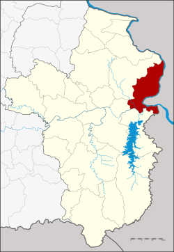
Si Mueang Mai is a district (Amphoe) in the northeastern part of Ubon Ratchathani province, northeastern Thailand; it may also be spelled Sri Mueang Mai.

<span class="mw-page-title-main">Pho Sai district</span> District in Ubon Ratchathani, Thailand

Pho Sai is a district (amphoe) in the northeastern part of Ubon Ratchathani province, northeastern Thailand.

<span class="mw-page-title-main">Wiang Kaen district</span> District in Chiang Rai, Thailand

Wiang Kaen is the easternmost district (amphoe) of Chiang Rai province, northern Thailand.

<span class="mw-page-title-main">Ban Dan district</span> District in Buriram, Thailand

Ban Dan is a district (amphoe) of Buriram province, northeastern Thailand.

<span class="mw-page-title-main">Kaeng Hang Maeo district</span> District in Chanthaburi, Thailand

Kaeng Hang Maeo is the northwesternmost district (amphoe) of Chanthaburi province, eastern Thailand.

<span class="mw-page-title-main">Ban Thi district</span> District in Lamphun, Thailand

Ban Thi is the northernmost district (amphoe) of Lamphun province, northern Thailand.

<span class="mw-page-title-main">Phana district</span> District in Amnat Charoen, Thailand

Phana is a district (amphoe) of Amnat Charoen province, northeastern Thailand.

<span class="mw-page-title-main">Lao Suea Kok district</span> District in Ubon Ratchathani, Thailand

Lao Suea Kok is a district (amphoe) in the northern part of Ubon Ratchathani province, northeastern Thailand.

<span class="mw-page-title-main">Sawang Wirawong district</span> District in Ubon Ratchathani, Thailand

Sawang Wirawong is a district (amphoe) in the central part of Ubon Ratchathani province, northeastern Thailand.

<span class="mw-page-title-main">Thung Si Udom district</span> District in Ubon Ratchathani, Thailand

Thung Si Udom is a district (amphoe) in the southwestern part of Ubon Ratchathani province, northeastern Thailand.

<span class="mw-page-title-main">Samrong district</span> District in Ubon Ratchathani, Thailand

Samrong is a district (amphoe) in the western part of Ubon Ratchathani province, northeastern Thailand.

<span class="mw-page-title-main">Tan Sum district</span> District in Ubon Ratchathani, Thailand

Tan Sum is a district (amphoe) in the central part of Ubon Ratchathani province, northeastern Thailand.

<span class="mw-page-title-main">Don Mot Daeng district</span> District in Ubon Ratchathani, Thailand

Don Mot Daeng is a district (amphoe) in the central part of Ubon Ratchathani province, northeastern Thailand. The district is named after the island Don Mot Daeng in the Mun River.

<span class="mw-page-title-main">Kut Khaopun district</span> District in Ubon Ratchathani, Thailand

Kut Khaopun is a district (amphoe) in the northern part of Ubon Ratchathani province, northeastern Thailand.

<span class="mw-page-title-main">Changhan district</span> District in Roi Et, Thailand

Changhan is a district (amphoe) in the northwestern part of Roi Et province, northeastern Thailand.

<span class="mw-page-title-main">Pathum Ratchawongsa district</span> District in Amnat Charoen, Thailand

Pathum Ratchawongsa is a district (amphoe) in the eastern part of Amnat Charoen province, northeastern Thailand.

<span class="mw-page-title-main">Lue Amnat district</span> District in Amnat Charoen, Thailand

Lue Amnat is a district (amphoe) in the southern part of Amnat Charoen province, northeastern Thailand.

<span class="mw-page-title-main">Senangkhanikhom district</span> District in Amnat Charoen, Thailand

Senangkhanikhom is a district (amphoe) in the northern part of Amnat Charoen province, northeastern Thailand.

References

  1. ประกาศกระทรวงมหาดไทย เรื่อง ย้ายที่ว่าการอำเภอโขงเจียม และตั้งกิ่งอำเภอบ้านด่าน จังหวัดอุบลราชธานี (PDF). Royal Gazette (in Thai). 74 (8 ง): 225–226. January 22, 1957. Archived from the original (PDF) on May 10, 2012.
  2. พระราชกฤษฎีกาตั้งอำเภอชุมพวง อำเภอเชียงยืน อำเภอแก้งคร้อ อำเภอสำโรงทาบ อำเภอคอนสาร อำเภอเซกา อำเภอทุ่งเสลี่ยม อำเภอบ้านด่าน อำเภอขนอม อำเภอบ้านแพรก อำเภอกระทู้ และอำเภอคลองใหญ่ พ.ศ. ๒๕๐๒ (PDF). Royal Gazette (in Thai). 76 (113 ก special): 8–11. December 10, 1959. Archived from the original (PDF) on July 18, 2011.
  3. พระราชกฤษฎีกาเปลี่ยนชื่ออำเภอบางแห่งในจังหวัดอุบลราชธานี พ.ศ. ๒๕๑๔ (PDF). Royal Gazette (in Thai). 88 (98 ก): 618–620. September 14, 1971. Archived from the original (PDF) on May 10, 2012.
  4. "อำเภอโขงเจียม". The Office of Academic Resources Ubon Ratchathani University (in Thai).