Transport in Thailand is varied, with no one dominant means of transport. For long distance travel, bus transport dominates. Low-speed rail travel has long been a rural long-distance transport mechanism, though plans are underway to expand services with high-speed rail lines extending to several major regions of Thailand. Road transportation is the primary form of freight transport across the country.

Khon Kaen is one of the four major cities of Isan, Thailand, also known as the "big four of Isan", the others being Udon Thani, Nakhon Ratchasima, and Ubon Ratchathani. It is the capital of Khon Kaen Province and the Mueang Khon Kaen District. Khon Kaen lies 450 kilometres (280 mi) north-northeast of Bangkok.

The National highways in India are a network of trunk roads that is owned by the Ministry of Road Transport and Highways. It is constructed and managed by the National Highway Authority of India (NHAI), the National Highways and Infrastructure Development Corporation (NHIDCL), and the public works departments (PWD) of state governments.

Sukhumvit Road, or Highway 3, is a major road in Thailand, and a major surface road of Bangkok and other cities. It follows a coastal route from Bangkok to Khlong Yai District, Trat border to Koh Kong, Cambodia
Federal Route 3 is a main federal road running along the east coast of Peninsula Malaysia. The 739 kilometres (459 mi) federal highway connects Rantau Panjang in Kelantan until Johor Bahru in Johor. The entire FT3 highway is gazetted as a part of the Asian Highway Network route 18.
Kunming–Bangkok Expressway is a proposed international expressway running from Kunming, Yunnan province, People's Republic of China, to Bangkok, Thailand via Laos The first expressway sections were opened in 2008.

Asian Highway 18 is a highway route included in Asian Highway Network, running from Hadyai in Thailand to Johor Bahru, Malaysia. Route AH18 runs along main eastern coastal road in southern Thailand and also along Federal Route of Malaysia.

Phet Kasem Road or Highway 4 is one of the four primary highways in Thailand, along with Phahonyothin Road, Mittraphap Road, and Sukhumvit Road. At 1,274 km, it is the longest highway in Thailand. It begins at Naowa Chamnian bridge in Bangkok Yai, Bangkok. It is named after Luang Phet Kasemwithisawasdi, the seventh director general of the Department of Highways.

Phahonyothin Road or Highway 1 is a major road in Bangkok and one of the four primary highways in Thailand, which include Mittraphap Road, Sukhumvit Road, and Phet Kasem Road. It begins at Victory Monument in Bangkok and runs north to the Burmese border, with a total length of 1,005 km (624 mi).
The motorways in Thailand is an intercity toll controlled-access highways network that currently spans 145 kilometres (90 mi). It is to be greatly extended to 4,154.7 kilometres (2,581.6 mi) according to the master plan. Thailand's motorway network is considered to be separate from Thailand's expressway network, which is the system of expressways, usually elevated, within Greater Bangkok. Thailand also has a provincial highway network.

The India–Myanmar barrier is a border barrier that India is constructing to seal its 1,624-kilometre (1,009 mi)-long border with Myanmar. India hopes to curtail cross-border crime, including goods, arms and counterfeit currency smuggling, drug trafficking, and insurgency. The United Nations Drug Control Programme (UNDCP) and International Narcotics Control Board (INCB) also warned that the region could become a major transit point for illicit drugs because of the poor state of border security facilities. Indian security forces blamed the porous border for the deaths of 200 security personnel and civilians in militancy-related violence in the region in 2001-2003. Four Northeast Indian states share the border with Myanmar: Arunachal Pradesh, Nagaland, Mizoram, and Manipur. Both national governments agreed to conduct a joint survey before erecting the fence. The Indian Home Ministry and its Myanmar counterpart completed the survey within six months and in March 2003 began erecting a fence along the border.

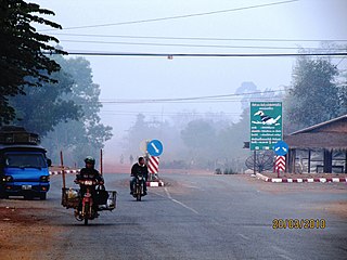
The Thai highway network follows the left-hand traffic rule of the road. The network is the twin responsibility of the Department of Highways, and the Department of Rural Roads, under the oversight of the Transportation ministry of Thailand. Public highways are also called public roads, especially when part of urban streets. The network spans over 70,000 kilometers across all regions of Thailand. Most are single carriageways. Dual carriageways have frequent u-turn lanes and intersections slowing down traffic. Coupled with the increase in the number of vehicles and the demand for a limited-access motorway, the Thai Government issued a Cabinet resolution in 1997 detailing the motorway construction master plan. Some upgraded sections of highway are being turned into a "motorway", while other motorways are not being built from highway sections.

Department of Rural Roads (DRR), กรมทางหลวงชนบท, Krom Thang Luang Chonnabot is a department of the Thai government, under the Ministry of Transport. It maintains rural roads, under a different numbering scheme from national roads, which are managed by the Department of Highways (DOH), กรมทางหลวง, Krom Thang Luang).

Highway 32 is a national highway in Thailand.

Asian Highway 12 (AH12) is a route of the Asian Highway Network, with a length of 1,195 km that runs from AH3 in Nateuy, Laos, through Muang Xay, Luang Prabang, Vang Vieng, Vientiane, Nong Khai, Udon Thani, Khon Kaen, Nakhon Ratchasima, and Saraburi until its terminus at AH1 in Nong Khae District, Saraburi Province, Thailand.

Asian Highway 16 (AH16) is a road in the Asian Highway Network running 1,031 kilometres (641 mi) from Tak, Thailand to Đông Hà, Vietnam connecting AH1 and AH2 to AH1 after AH1 takes a turn from south to North after crossing Cambodia. The route is as follows:

Asian Highway 15 (AH15) is a road in the Asian Highway Network running 566 kilometres (352 mi) from Vinh, Vietnam to Udon Thani, Thailand connecting AH1 to AH12. The route is as follows:

Asian Highway 19 (AH19) is a road in the Asian Highway Network running 459 km from Nakhon Ratchasima to Bangkok in Thailand. This highway connects Nakhon Ratchasima to Bangkok via port city of Laem Chabang.

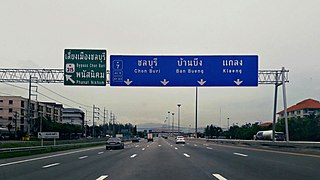
The Bangkok−Ban Chang Motorway is the first intercity-motorway in Thailand, connecting Bangkok to Chonburi, Pattaya, and Map Ta Phut. It has the route number 7 as Motorway Route 7, and is part of Asian Highway Network as AH Route 19, and AH Route 123. The entire length from Bangkok to Pattaya is 125.865 kilometres (78.209 mi) and the posted speed limit is 120 kilometres per hour (75 mph), enforced primarily by speed cameras. An extension between Pong and Map Tha Put opened in May 2020. It is part of transport network development project in Eastern seaboard.


