
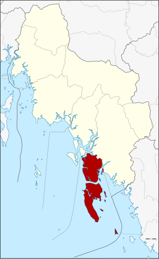
Krabi is a province (changwat) of southern Thailand, on the shore of the Andaman Sea. Neighbouring provinces are Phang Nga, Surat Thani, Nakhon Si Thammarat, and Trang. Phuket province lies to the west across Phang Nga Bay. Krabi town is the seat of the provincial government.

Phang Nga is one of the southern provinces (Changwat) of Thailand, on the shore of the Andaman Sea to the west and Phang Nga Bay to the south. Neighbouring provinces, from north and moving clockwise, are Ranong, Surat Thani, and Krabi. Towards the south of Phang Nga is the Phuket province, connected by the Sarasin Bridge.

Phuket ; Thai: ภูเก็ต,, Malay: Bukit or Tongkah is one of the southern provinces (changwat) of Thailand. It consists of the island of Phuket, the country's largest island, and another 32 smaller islands off its coast. Phuket lies off the west coast of mainland Thailand in the Andaman Sea. Phuket Island is connected by the Sarasin Bridge to Phang Nga province to the north. The next nearest province is Krabi, to the east across Phang Nga Bay.

Ko Samui, often locally shortened to Samui, is an island off the east coast of Thailand. Geographically in the Chumphon Archipelago, it is part of Surat Thani Province, though as of 2012, Ko Samui was granted municipal status and thus is now locally self-governing. Ko Samui, with an area of 228.7 square kilometres (88.3 sq mi), is Thailand's second largest island after Phuket. In 2018, it was visited by 2.7 million tourists.
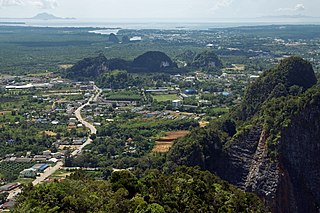
Krabi is the capital of and main town in Krabi Province, on the west coast of southern Thailand, where the Krabi River flows into Phang Nga Bay. The town lies 650 km (400 mi) south of Bangkok, and as of 2020, has a population of 32,644. As in much of southern Thailand, the local economy centres largely on tourism.

Phang Nga is a town in southern Thailand, capital of Phang Nga Province. The town covers the whole tambon Thai Chang of Mueang Phang Nga district. As of 2005 it had a population of 9,559 and covered an area of 6.75 km². Phang Nga is 764 km from Bangkok by road.

Southern Thailand, Southern Siam or Tambralinga is a southernmost cultural region of Thailand, separated from Central Thailand region by the Kra Isthmus.

The Surin Islands is a continental archipelago of five islands in the Andaman Sea, 55 kilometres (34 mi) from the Thai mainland. Administratively, the islands are part of Tambon Ko Phra Thong, Khura Buri district, in Phang Nga province, Thailand.

Ko Lanta Yai is an island in the Strait of Malacca off the west coast of Thailand, between the Phi Phi Islands and the mainland. It is administratively part of Krabi Province, most of which is on the mainland. Together with neighboring Ko Lanta Noi, which forms the Ko Lanta archipelago, and several other islands, it forms the amphoe of Ko Lanta District.
Ko Lanta is a district (amphoe) in Krabi province, Thailand.
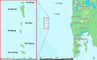
The Similan Islands is a continental archipelago in the Andaman Sea off the coast of, and part of, Phang Nga Province in southern Thailand. It is the maritime border between India and Thailand. It was established as Mu Ko Similan National Park in 1982 after a one-year assessment by the forestry department.

Phang Nga Bay is a 400 km2 (150 sq mi) bay in the Andaman Sea between the island of Phuket and the mainland of the Kra Isthmus of southern Thailand. Since 1981, an extensive section of the bay has been protected as the Ao Phang Nga National Park. The park is in Phang Nga Province, at 8°17′N98°36′E.
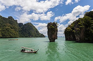
Khao Phing Kan or Ko Khao Phing Kan, commonly known in English as James Bond Island, is an island in Thailand, in Phang Nga Bay northeast of Phuket. About 40 metres (130 ft) from the shores of Khao Phing Kan lies a 20-metre (66 ft) tall islet called Ko Ta Pu or Ko Tapu.

Ko Yao is a district (amphoe) in Phang Nga province in Thailand's south.
Ko Phra Thong is an island in Khura Buri District, Phang Nga Province, southern Thailand on the Andaman Sea. It has an area of 88 square kilometres (34 sq mi) and is separated from the mainland by a seven-metre-deep (23 ft) canal. The nearest town is Khura Buri, on the mainland about 10 km (6.2 mi) east.
Ko Nom Sao are twin islands in Phang Nga Bay, and are part of the Ko Panyi (เกาะปันหยี) subdistrict (tambon), Phang Nga Province, Thailand.
Moklen is an Austronesian language spoken on the western coast of southern Thailand. It is related to but distinct from the Moken language of Myanmar and southern Thailand. Unlike Moken, it is not spoken in Myanmar.

Ko Libong (เกาะลิบง) is one of 550 islands in the Andaman Sea. Lying off the coast of Thailand, it is a sub-district of Kantang District, Trang Procince, which includes Mu Ko Libong Archipelago and a small section of the shoreline near Kantang.

