Phu Phan Mountains

Last updated • 2 min readFrom Wikipedia, The Free Encyclopedia
Phu Phan Mountains
ทิวเขาภูพาน
Phu Phan Mountains - view from Wat Tham Kham.jpg
Phu Phan Mountains, view from Wat Tham Kham
Highest point
Peak Phu Lang Ka
Elevation 624 m (2,047 ft)
Coordinates 16°46′22″N104°21′45″E / 16.77278°N 104.36250°E / 16.77278; 104.36250
Dimensions
Length180 km (110 mi)NW/SE
Width50 km (31 mi)NE/SW
Geography
Isaanmountains.svg
Map of Isan showing the Phu Phan Range
CountryThailand
Region(s) Nong Bua Lamphu
Udon Thani
Sakon Nakhon
Nakhon Phanom
Kalasin
Roi Et
Maha Sarakham
Mukdahan
Geology
Rock age Early Cretaceous
Rock type(s) Sandstone and siltstone

The Phu Phan mountains (Thai : ทิวเขาภูพาน, RTGS: Thio Khao Phu Phan, pronounced [tʰīwkʰǎwpʰūːpʰāːn] ; Northeastern Thai : ทิวเขาภูพานThio Khao Phu Phan, pronounced [tʰîwkʰǎwpʰûːpʰâːn] ) are a range of hills dividing the Khorat Plateau of the Isan region of Thailand into two basins: the northern Sakhon Nakhon Basin, and the southern Khorat Basin. [1]

Contents

The silhouette of the Phu Phan Mountains appears in the provincial seal of Kalasin since they form the northern boundary of the province. [2]

The Phu Phan mountains are among the places in Thailand more severely affected by the Illegal logging of Phayung (Siamese Rosewood) trees. Although officially a protected tree, the cutting and trading of the endangered rosewood trees has been going unabated in Thailand's mountainous forested zones, even in the protected areas. In Thailand and in China this wood is highly valued in the furniture industry. [3] [4]

Etymology

The name of the range is derived from the characteristic tabletop shape of its peaks, for phan is a kind of traditional tray on a pedestal.

Phu is the word for mountain in the Isan/Lao language (as opposed to khao in central and southern Thai and doi in northern Thai).

Geography

The Phu Phan Mountains rise above the plateau and are not prominent. They straddle most of the provinces of northern and eastern Isan, including Khon Kaen, Nong Bua Lamphu, Udon Thani, Sakon Nakhon, Nakhon Phanom, Kalasin, Roi Et, Maha Sarakham, and Mukdahan Province.

The highest elevation of the Phu Phan Range is the 641 m high summit known as Phu Lang Ka. It is in Nakhon Phanom Province. [5] Other important peaks are 624 m high Phu Mai Hia in Mukdahan Province [6] and the 563 m high summit known as Phu Langka Nuea in Nakhon Phanom Province.

The hills are mostly deforested, although patches covered with mixed deciduous forest remain in zones spread across the range. [7]

Phu Phan Royal Palace is in the area, as is the Nam Un dam. [8] Other local sights are Lake Nong Han near Sakon Nakhon and the Khmer-style chedi ruins of Phu Phek, dating from 1050.

Protected areas

The area of the Phu Phan mountains includes national parks and other protected areas: [9] [10]

See also

Related Research Articles

<span class="mw-page-title-main">Kalasin province</span> Province of Thailand

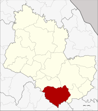
Kalasin is one of Thailand's seventy-six provinces (changwat), located in upper northeastern Thailand, also called Isan. The province was established by the Act Establishing Changwat Kalasin, BE 2490 (1947), and it came into existence on 1 October 1947. Neighboring provinces are Sakon Nakhon, Mukdahan, Roi Et, Maha Sarakham, Khon Kaen, and Udon Thani.

<span class="mw-page-title-main">Sakon Nakhon province</span> Province of Thailand

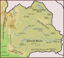
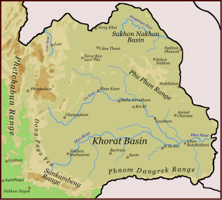
Sakon Nakhon is one of Thailand's seventy-six provinces (changwat). It lies in upper northeastern Thailand and is also called Isan. Neighboring provinces are Nong Khai, Bueng Kan, Nakhon Phanom, Mukdahan, Kalasin, and Udon Thani. Its capital is Sakon Nakhon.

<span class="mw-page-title-main">Phetchabun Mountains</span> Mountain range in northern Thailand

The Phetchabun mountains are a mountain massif in Phetchabun, Phitsanulok, Loei and Chaiyaphum Provinces, Thailand. It consists of two parallel mountain chains, with the valley of the Pa Sak River in the middle.

<span class="mw-page-title-main">Dângrêk Mountains</span> Mountain range in southeast Asia

The Dângrêk Mountains, also the Dângrêk Range, is a mountain range forming a natural border between Cambodia and Thailand. Anlong Veng is the final stronghold of the Khmer Rouge of Democratic Kampuchea and the Maoist dictator Pol Pot which is also the final resting place in his jungle headquarters.

<span class="mw-page-title-main">Dong Phaya Yen Mountains</span>

Dong Phaya Yen or Dong Phya Yen is a mountain range in Phetchabun, Chaiyaphum, Lopburi, Saraburi, and Nakhon Ratchasima Provinces, Thailand.

<span class="mw-page-title-main">Phu Phan district</span> District in Sakon Nakhon, Thailand

Phu Phan is a district (amphoe) of Sakon Nakhon province, northeast Thailand.

<span class="mw-page-title-main">Tao Ngoi district</span> District in Sakon Nakhon, Thailand

Tao Ngoi is a district (amphoe) of Sakon Nakhon province, northeast Thailand.

<span class="mw-page-title-main">Dong Luang district</span> District in Mukdahan, Thailand

Dong Luang is a district (amphoe) of Mukdahan province, northeastern Thailand.

<span class="mw-page-title-main">Sankamphaeng Range</span> Mountain range in Thailand

The Sankamphaeng Range, also Sankambeng Range or Sungumpang Range is one of the mountain ranges separating eastern Thailand from the northeast or Isan. It is in Nakhon Nayok, Prachinburi, Sa Kaeo, Saraburi, and Nakhon Ratchasima Provinces, Thailand.

<span class="mw-page-title-main">Phra That Phu Pek</span> Hindu temple in Sakon Nakhon, Thailand

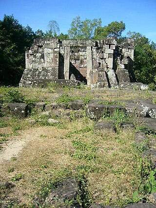
Phra That Phu Pek (Thai:พระธาตุภูเพ็ก) is an ancient temple in Sakon Nakhon Province, in the Isan region of Thailand. This ancient Khmer ruin was built from sandstone, standing on a laterite base. This is a Buddhist temple ruin of Khmer origin in the form of a chedi, it was built in the 16th-17th Buddhist century. The ruin is special as it houses a solar calendar, a cube-shaped rock, in its stupa. The ancients used it for indicating the position of the sun, important for religious rites and agricultural seasons.

<span class="mw-page-title-main">Nakhon Si Thammarat Range</span> Mountain range on the Malay Peninsula in southern Thailand

The Nakhon Si Thammarat Range is a mountain range on the Malay Peninsula in southern Thailand, running in a north–south direction. This mountain chain is also sometimes named Banthat Range (ทิวเขาบรรทัด), a name which is however also used to refer to the Chanthaburi mountain range.

<span class="mw-page-title-main">Luang Prabang Range</span> Mountain range in northwestern Laos and northern Thailand

The Luang Prabang Range, named after Luang Prabang, is a mountain range straddling northwestern Laos and Northern Thailand. Most of the range is located in Sainyabuli Province (Laos), as well as Nan and Uttaradit Provinces (Thailand), with small parts in Phitsanulok and Loei Provinces. Several rivers such as the Nan, Pua and Wa rivers, have their sources in this range. Phu Fa waterfall, the biggest and the tallest waterfall in Nan Province, is also located in these mountains. This range is part of the Luang Prabang montane rain forests ecoregion.

<span class="mw-page-title-main">Phi Pan Nam Range</span> Mountain range in Thailand and Laos

The Phi Pan Nam Range, also Pee Pan Nam, is a 400 km (249 mi) long system of mountain ranges in the eastern half of the Thai highlands. The range lies mostly in Thailand, although a small section in the northeast is within Sainyabuli and Bokeo provinces of Laos.

<span class="mw-page-title-main">Phu Langka Forest Park</span> Protected area in Thailand

The Phu Langka Forest Park, or Phu Lang Ka Forest Park, is a protected area of the Phi Pan Nam Range located in Chiang Kham District and Pong District, Phayao Province, Thailand. The park was established on May 8, 2002, and covers an area of 12.48 km2 (4.82 sq mi).

<span class="mw-page-title-main">Phuket Range</span> Mountain range in Thailand

The Phuket Range is a subrange of the Tenasserim Hills in the Kra Isthmus, Thailand.

<span class="mw-page-title-main">Phu Phan National Park</span> National park in Thailand

Phu Phan National Park is a national park in Sakon Nakhon and Kalasin provinces, Thailand. This isolated park covers a wide jungle area in the Phu Phan Mountains of Isan.

<span class="mw-page-title-main">Phu Pha Yon National Park</span> National park in Thailand

Phu Pha Yon National Park is a national park in northeastern Thailand (Isan). Formerly known as Huai Huad National Park (อุทยานแห่งชาติห้วยหวด). The national park covers the area of Mueang Sakon Nakhon, Khok Si Suphan and Tao Ngoi districts of Sakon Nakhon province, Na Kae district of Nakhon Phanom province and Dong Luang, Khamcha-i districts of Mukdahan province.

Ban Kok Kok is a muban (village) in Kok Tum Sub-district, Dong Luang District, Mukdahan Province, Isan region.

References

  1. Schuler, Ulrich. "NE-Thailand (Isan)". Geosciences. Retrieved 23 July 2017.
  2. Seals of The Provinces of Thailand
  3. Fredrickson, Terry (2011-09-19). "Forest robbery". Bangkok Post. Retrieved 10 November 2015.
  4. Waewkraihong, Jakkrit (6 Feb 2013). "Cambodians caught for phayung smuggling". Bangkok Post. Retrieved 10 November 2015.
  5. "PHU LANGKA NATIONAL PARK". Tourism Authority of Thailand (TAT). Retrieved 23 July 2017.
  6. "Phu Mai Hia". getamap.net. Retrieved 23 July 2017.
  7. Phu Kao - Phu Phan Kham National Park Archived 2012-04-26 at the Wayback Machine
  8. Nam Un Dam Archived 2012-04-26 at the Wayback Machine
  9. National Parks Archived 2008-12-04 at the Wayback Machine
  10. "Phu Phan National Park". Trek Thailand. Retrieved 23 July 2017.