Dângrêk Mountains

Last updated • 7 min readFrom Wikipedia, The Free Encyclopedia
Dângrêk Mountains
Dongrakfrommawidaeng1.jpg
Dângrêk Mountains, looking east from Maw I-daeng, Thailand
Highest point
Peak Phu Khi Suk
Elevation 753 m (2,470 ft)
Dimensions
Length300 km (190 mi)E/W
Width40 km (25 mi)N/S
Naming
Native name
  • ជួរភ្នំដងរែក (Khmer)
  • ทิวเขาพนมดงรัก (Thai)
Geography
Isaanmountains.svg
Mountain ranges in Central and northeastern Thailand
Countries
  • Thailand
  • Cambodia
  • Laos
Range coordinates 14°20.25′N103°55′E / 14.33750°N 103.917°E / 14.33750; 103.917
Borders onThai/Cambodian
Geology
Rock age Jurassic
Rock types
Silhouette of the Dangrek Mountains, looking north from Cambodia at dawn. Dangrek09.JPG
Silhouette of the Dângrêk Mountains, looking north from Cambodia at dawn.
The Preah Vihear Temple area, on the shoulder of one of the Dangrek Mountains. Preahvihear112.jpg
The Preah Vihear Temple area, on the shoulder of one of the Dângrêk Mountains.
Preah Vihear Temple and border lines on dispute Prahvihear.jpg
Preah Vihear Temple and border lines on dispute

The Dângrêk Mountains ( /ˈdɑːŋrɛk/ ; Khmer : ជួរភ្នំដងរែក, Chuŏr Phnum Dângrêk [cuəpʰnomɗɑːŋrɛːk] ; Thai : ทิวเขาพนมดงรัก, RTGS: Thio Khao Phanom Dongrak [tʰīwkʰǎwpʰānōmdōŋrák] , lit.'Mountain of Carrying stick shape'), also the Dângrêk Range, is a mountain range forming a natural border between Cambodia and Thailand. Anlong Veng is the final stronghold of the Khmer Rouge of Democratic Kampuchea and the Maoist dictator Pol Pot (Saloth Sar) which is also the final resting place in his jungle headquarters.

Contents

Geography

Despite the length of the range, the Dângrêk are a relatively low mountain system, the average elevation of the summits being around 500 m. The highest peak is Phu Khi Suk (Thai : ภูขี้สุข), an inconspicuous 753 metres at the eastern end, in the Chong Bok (603 m) area, where the borders of Thailand, Laos, and Cambodia intersect. [1] Other summits are Phu Khok Yai (693 m), Phu Chep Thong (692 m), Phu Tangok (689 m), Phalan Sun (670 m), Phanom Ai Nak (638 m), Phanom Thaban (582 m) and 374 m high Khao Banthat (เขาบรรทัด) at the western end. [2]

The northern side of the Dângrêk Mountains is gently sloping, while the sides facing south are usually a steep escarpment that dominates the plain of northern Cambodia. The watershed along the escarpment in general terms marks the boundary between Thailand and Cambodia; however, there are exceptions. The main road connecting the two countries in this area cuts through a pass in the Dângrêk Mountains at O Smach. A small administrative division of Thailand in Surin Province, Phanom Dong Rak District, bears the name of this mountain range. [3]

Geology

The mountains are formed mainly of massive sandstone with slate and silt. A few characteristic basalt hills such as Dong Chan Yai (293 m) and Dong Chan Noi (290 m) are found on the northern side of the mountain chain in Ubon Ratchathani Province.

Ecology

The Dângrêk Mountain range is mostly covered by dry evergreen forest, mixed dipterocarp forest, and deciduous dipterocarp forest. Tree species like Pterocarpus macrocarpus , Shorea siamensis and Xylia xylocarpa var. kerrii dominate. There has been much illegal logging both on the Thai as well as on the Cambodian side, leaving large hill stretches denuded, vulnerable tree species such as Dalbergia cochinchinensis have also been affected. [4] Forest fires are also common in the hills during the dry season. [5]

There is not much wildlife left in the Dângrêk Mountains. Wild hog, deer, barking deer, rabbit, squirrel, gibbon and civet are some of the animals to be found in the areas where there has been no habitat loss due to human encroachment. Among the endangered species, the white-winged duck deserves mention.

The Phanom Dong Rak Wildlife Sanctuary is a protected area in the area of the range in Sisaket Province. [6] Other protected areas are Phu Chong-Na Yoi National Park, Khao Phra Wihan National Park, Yot Dom Wildlife Sanctuary, [7] Huai Sala Wildlife Sanctuary, [8] Hua Tabtan Hadsamran Wildlife Sanctuary and Ta Phraya National Park on the Thai side, as well as Banteay Chhmar Protected Landscape, Preah Vihear Temple Protected Landscape and the Preah Vihear Protected Forest on the Cambodian side.

History

The Dângrêk Mountains were part of the ancient Khmer Empire, which spread northwards across them, culminating with the almost complete control of the Isan area in 1220 under Jayavarman VII. [9] Among the archaeological remains in the mountain area there are stone carvings on the Pha Mo I-Daeng cliff, ancient stone-cutting quarries, as well as the Sa Trao reservoir. There are also remains of sanctuaries that were built as homes to spirits called phi ton nam ('watershed spirits') in different spots along the border area of the Dângrêk mountain chain. However, the largest and most important archaeological site in these mountains is the Prasat Preah Vihear compound, a Shaivite temple of the Khmer imperial times dated from the reign of Suryavarman I [10] :96 in a dramatic location on top of a high hill. [11]

In 1975, following the fall of the Lon Nol regime on 17 April the Khmer Rouge entered the capital Phnom Penh. But the final area held by the ill-fated Khmer Republic in any form would be the Preah Vihear Temple in these mountains. Khmer National Armed Forces occupied the place in late-April that year. [12] They held on for a few weeks until the hill where the temple stands was finally taken by the Khmer Rouge on 22 May.

Between 1975 and 1979 many Cambodians fled the violence in their country across these mountains. In one of the worst cases of enforced repatriation in UN history, the Thai military forcefully sent as many as 40,000 refugees back into Cambodia often through heavily mined areas despite their unwillingness to return. Many would die of lack of food and exposure in the mountains. To compound matters, there were also bandits hiding in the forests preying on the hapless refugees. At that time there were many corpses, lying rotting unburied, strewn about the Dângrêk Mountains. [13] [14]

In the 1984 movie The Killing Fields , the Dângrêk Mountains are the final escarpment that Pran, portrayed by actor Haing S. Ngor, climbs in order to reach the safety of the refugee camp across the border in Thailand. The contrast between the steep-faced Cambodian side and the smooth northern slope of the cordillera is well displayed in this movie.

Even though some areas have been cleared, vast numbers of landmines were laid by the People's Republic of Kampuchea government in the 1980s as part of a huge planned operation using thousands of conscripted workers along the Dângrêk mountain range and other parts of the Thai-Cambodian border. The alleged purpose was to hinder Pol Pot's regrouped Khmer Rouge from entering Cambodia from Thailand. This defensive line, part of the legacy of the violent conflicts that engulfed Cambodia in the latter part of the 20th century, is known as the K-5 Belt.

After the end of the Vietnamese occupation of Cambodia in 1989 and the withdrawal of the Vietnam People's Army, the Khmer Rouge rebuilt their former bases in the Dângrêk mountain range area, along the border of Cambodia in order to fight against the Kampuchean People's Revolutionary Armed Forces, the armed forces of the State of Cambodia. Anlong Veng, a small town at the foot of these hills, became for a while the main "capital" of the Khmer Rouge. In the 1990s the Khmer Rouge still controlled Anlong Veng, where there was one of the first "killing fields" after the fall of "Democratic Kampuchea". Anlong Veng became the final resting place of the Cambodian dictator Pol Pot (Saloth Sar) where it was used for the Khmer Rouge to rebuild their former bases on 18 February 1994.

There is still an unexcavated site in a forest with landmines in the Dângrêk Mountains, about 6 km north of Anlong Veng where 3,000 people were allegedly killed by the Khmer Rouge for having become "corrupted" as late as between 1993 and 1997. These executions were carried out during Ta Mok's leadership in the area. [15]

Illegal logging of phayung ('Siamese rosewood') is rampant in the Dângrêk Mountains. [4] Although officially a protected tree, the logs cut on the Cambodian side are usually smuggled into Thailand by the hundreds. [16] In Thailand and China this wood is highly valued in the furniture industry. [17]

Preah Vihear temple dispute

In 1959, the Thai military seized the ancient Khmer Preah Vihear Temple from Cambodia. In 1962 Cambodia gained worldwide recognition for sovereignty from the International Court. Recently the issue of Cambodian sovereignty in the Cambodian–Thai border dispute has been used by certain nationalist factions in Thailand as a tool to help discredit the current Thai government as part of the continuing power struggle within Thailand.[ citation needed ]

In mid-2011, three districts of Surin Province in the Dângrêk Range were declared "disaster zones" following border clashes between the Thai and the Cambodian military. The area declared a disaster zone included a total of 142 villages. [18] Following this official declaration, about 6,000 civilians were evacuated from the villages of the area. [19] [20]

See also

Related Research Articles

<span class="mw-page-title-main">Sisaket province</span> Province of Thailand

Sisaket province is one of Thailand's seventy-six provinces (changwat). It lies in lower northeastern Thailand, a region called Isan. Neighboring provinces are : Surin, Roi Et, Yasothon, and Ubon Ratchathani. To the south it borders Oddar Meancheay and Preah Vihear of Cambodia.

<span class="mw-page-title-main">Surin province</span> Province of Thailand

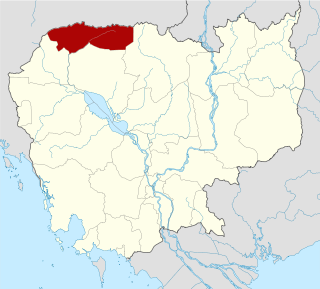
Surin is one of Thailand's seventy-seven provinces (changwat). It lies in lower northeastern Thailand, also called Isan. Neighboring provinces are Buriram, Maha Sarakham, Roi Et, and Sisaket. To the south it borders Oddar Meancheay of Cambodia. Surin covers a total area of 8,124 km2 (3,137 sq mi) from the Mun River in the north to the Dangrek Mountains in the south. The capital, Surin city, in the western central region province is 434 km from Bangkok.

Articles related to Cambodia and Cambodian culture include:

<span class="mw-page-title-main">Oddar Meanchey province</span> Province of Cambodia

Oddar Meanchey is a province of Cambodia in the remote northwest. It borders the provinces of Banteay Meanchey to the west, Siem Reap to the south and Preah Vihear to the east. Its long northern boundary demarcates part of Cambodia's international border with Thailand. The capital is Samraong.

<span class="mw-page-title-main">Preah Vihear province</span> Province of Cambodia

Preah Vihear is a province (khaet) of Cambodia. It borders the provinces of Oddar Meanchey and Siem Reap to the west, Kampong Thom to the south and Stung Treng to the east. Its northern boundary forms part of Cambodia's international border with Thailand and Laos. Its capital is Preah Vihear.

<span class="mw-page-title-main">Phu Phan Mountains</span> Mountain range in Thailand

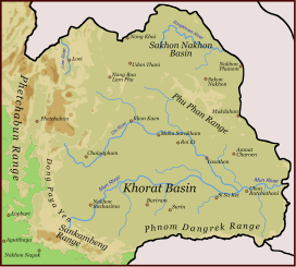
The Phu Phan mountains are a range of hills dividing the Khorat Plateau of the Isan region of Thailand into two basins: the northern Sakhon Nakhon Basin, and the southern Khorat Basin.

<span class="mw-page-title-main">Preah Vihear Temple</span> Ancient Khmer temple in Cambodia

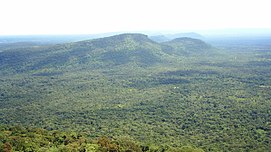
Preah Vihear Temple is an ancient Hindu temple built by the Khmer Empire, located on top of a 525-metre (1,722 ft) cliff in the Dângrêk Mountains, in the Preah Vihear province of Cambodia.

<span class="mw-page-title-main">Nam Yuen district</span> District in Ubon Ratchathani, Thailand

Nam Yuen is the southernmost district (amphoe) of Ubon Ratchathani province, northeastern Thailand.

<span class="mw-page-title-main">Khao Phra Wihan National Park</span> Protected natural area in Sisaket Province, Thailand

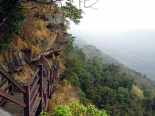
Khao Phra Wihan National Park is a protected natural area in Sisaket Province, Thailand, that contains numerous ruins of the 11th century Khmer Empire. The park lies 98 km (61 mi) south of the town of Sisaket, at the end of Thai highway 221. Sited on a red stone cliff that is part of the Dangrek mountain range on the southern edge of the Khorat Plateau, it abuts the international border between Thailand's Sisaket Province and Cambodia's Preah Vihear Province. The name of the cliff in the Royal Thai General System of Transcription is Pha Mo I Daeng (ผามออีแดง). The park was established on 20 March 1998, with an area of 81,250 rai ~ 130 square kilometres (50 sq mi).

Anlong Veng is a district (srok) in Oddar Meanchey province in Cambodia. The main town in the district is also called Anlong Veng. The population of the district could not be counted during the 1998 census of Cambodia due to ongoing conflict during the time of the census. It is estimated that 35% of the population in Anlong Veng were former Khmer Rouge soldiers including the Maoist dictator Pol Pot.

<span class="mw-page-title-main">Cambodian–Thai border dispute</span> 2008–2011 international dispute

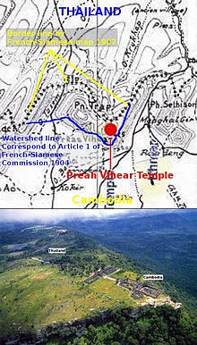
The Cambodian–Thai border dispute began in June 2008 as part of a century-long dispute between Cambodia and Thailand involving the area surrounding the 11th-century Preah Vihear Temple, in the Dângrêk Mountains between Choam Khsant District, Preah Vihear Province of northern Cambodia and the Kantharalak District, Sisaket Province of northeastern Thailand.

<span class="mw-page-title-main">Sankamphaeng Range</span> Mountain range in Thailand

The Sankamphaeng Range, also Sankambeng Range or Sungumpang Range is one of the mountain ranges separating eastern Thailand from the northeast or Isan. It is in Nakhon Nayok, Prachinburi, Sa Kaeo, Saraburi, and Nakhon Ratchasima Provinces, Thailand.

<span class="mw-page-title-main">Cambodia–Thailand relations</span> Bilateral relations

Bilateral relations between Cambodia and Thailand date to the 13th century during the Angkor Era. The Thai Ayutthaya Kingdom gradually displaced the declining Khmer Empire from the 14th century, French protectorateship separated Cambodia from modern Thailand at the turn of the 19th–20th centuries, and diplomatic relations between the modern states were established on 19 December 1950.

O Smach, also spelled O'Smach or Ou Smach, is a small Cambodian town on the Thai border in Samraong Municipality of Oddar Meanchey Province. Until 1999, there were intermittent battles, and the area was unsafe as the last remaining Khmer Rouge still had control of nearby Anlong Veng. In 2003, an international border crossing was opened between O Smach and the adjacent town of Chong Chom in Thailand's Surin Province. There has since opened a strip of casinos between the Cambodian and Thai passport control counters, enabling Thais to gamble in Cambodia without needing to go through Cambodian immigration. Gambling is illegal in Thailand and gambling in Cambodia is legal only for foreign passport holders. O Smach is at the northern terminus of Road 68 which turns north off National Highway 6 at Kravanh in Siem Reap Province.

<span class="mw-page-title-main">Prasat Ta Muen Thom</span> 11th-century Khmer temple on the Cambodia-Thailand border

Prasat Ta Muen Thom or Prasat Ta Moan Thom is a Khmer temple located on Cambodian-Thai border.

Prasat Ta Krabey or Prasat Ta Krabei, in Khmer and also known as Prasat Ta Khwai, in Thai, is a disputed Khmer temple which was built during Angkor period, the golden age of Cambodian history. This 11th century religious site was constructed in order to be dedicated to Hindu god Shiva and has become a tourist attraction site near Cambodian-Thai border in recent years.

<span class="mw-page-title-main">Cambodia–Thailand border</span> International border

The Cambodia–Thailand border is the international border between Cambodia and Thailand. The border is 817 km (508 mi) in length and runs from the tripoint with Laos in the north-east to the Gulf of Thailand in the south.

Phrai Phatthana is a tambon (subdistrict) of Phu Sing District, Sisaket Province, lower northeastern Thailand.

<span class="mw-page-title-main">Dangrek genocide</span>

The Dangrek genocide, also known as the Preah Vihear pushback, is a border incident which took place along the Dangrek Mountain Range on the Thai-Cambodian border which resulted in the death of many mostly Sino-Khmer refugees who were refused asylum by the Kingdom of Thailand in June 1979.

References

  1. Roadway Thailand Atlas, Groovy Map Co., Ltd. © 4/2010
  2. Chong Bok
  3. "Phanom Dong Rak". Archived from the original on 2012-04-26. Retrieved 2011-12-17. "Phanom Dong Rak Sub". Archived from the original on 2012-04-26. Retrieved 2011-12-17.
  4. 1 2 DSI claims illegal logging rampant - Bangkok Post
  5. Community Forestry International - Oddar Meancheay
  6. "Phanom Dong Rak Wildlife Sanctuary". Archived from the original on 2012-09-11. Retrieved 2012-02-19.
  7. "Yot Dom Wildlife Sanctuary". Archived from the original on 2014-02-27. Retrieved 2012-02-19.
  8. "Huai Sala Wildlife Sanctuary". Archived from the original on 2012-09-11. Retrieved 2012-02-19.
  9. Bernard Pjilippe Groslier, Prospection des Sites Khmers du Siam, Paris, 1980
  10. Higham, C., 2001, The Civilization of Angkor, London: Weidenfeld & Nicolson, ISBN   9781842125847
  11. Svasti, Pichaya (22 May 2008). "A fine line; The sovereignty dispute over sacred site Preah Vihear continues". SEAArch - Southeast Asian Archaeology. Bangkok Post. Retrieved 20 June 2019.
  12. Fenton, James (25 April 1975). "The bitter end in Cambodia". The New Statesman. Archived from the original on 20 June 2019. Retrieved 20 June 2019. "The bitter end in Cambodia". Archived from the original on 20 June 2019. Retrieved 20 June 2019.{{cite web}}: CS1 maint: bot: original URL status unknown (link)
  13. The Mental Health Conditions of Cambodian Refugee Children and Adolescents
  14. Ray, Nick (2002). Cambodia. Lonely Planet. ISBN   9781740591119.
  15. Kelvin Rowley, Second Life, Second Death: The Khmer Rouge After 1978 Archived 2016-02-16 at the Wayback Machine
  16. Cambodians caught for phayung smuggling - Bangkok Post
  17. Illegal Cambodian loggers add to tensions
  18. Bangkok Post - 3 Surin border districts 'disaster zones' [ dead link ]
  19. Relief Web - Over 6,000 people in Surin evacuated after border clashes
  20. Bangkok Post - Evacuation images [ dead link ]