Climate change in the Marshall Islands

Last updated
Image of Majuro, Marshall Islands Majuro (40325945).jpg
Image of Majuro, Marshall Islands

Climate change in the Marshall Islands is a major issue for the country. As with many countries made up of low-lying islands, the Marshall Islands is highly vulnerable to sea level rise and other impacts of climate change. The atoll and capital city of Majuro are particularly vulnerable, and the issue poses significant implications for the country's population. These threats have prompted Marshallese political leaders to make climate change a key diplomatic issue, who have responded with initiatives such as the Majuro Declaration.

Contents

The Human Rights Measurement Initiative [1] finds that the climate crisis has worsened human rights conditions in the Marshall Islands greatly (5.0 out of 6). [2] Human rights experts reported that the climate crisis has negatively impacted the economy, increased rates of unemployment, and lead to relocations to higher areas or migrations to other countries. [2]

Effects on the natural environment

The Marshall Islands is a collection of low-lying islands and atolls in the middle of the Pacific Ocean, all less than six feet in average elevation. Due to the geographic and topographic situation of these islands, they are placed in a position of intense risk in terms of exposure to the effects of climate change. [3] Sea level rise has already encroached upon the islands, and high tides and frequent storms continue to threaten local homes and property. Recent research indicates that sea levels have been increasing by 3.4 millimetres (0.13 inches) per year. A one-meter rise could result in the loss of 80 percent of the Majuro Atoll, which is home to half the nation's population. [4] The underwater fresh water supply has been salinated by this influx of seawater. In 2013 over 200 homes were damaged in the capital Majuro, and the airport was forced to close due to particularly high tides. [5]

Effects on people

Satellite Image of Ebeye Island, Marshall Islands Ebeye Island.jpg
Satellite Image of Ebeye Island, Marshall Islands

To a certain extent, the Marshallese are trapped on their islands, such as the Majuro Atoll, when large storms or tides occur, having no recourse to evacuate to higher grounds or neighbouring islands. The geographic isolation of the Marshall Islands renders any disaster caused by climate change especially destructive. Particularly dangerous are king tides, exceptionally high tides, which occur only a few times a year. To preserve their land and fight off tides and storms, residents have resorted to building private sea walls for their immediate protection. [6] A study by Murray Ford which compared aerial photographs of the Wotje Atoll of the Marshall Islands, found that "shorelines interpreted from high resolution satellite imagery captured between 2004 and 2012 indicate that shorelines within this sample of islands are largely in an erosive state". [7] Industries and livelihoods on the Marshall Islands are also threatened by climate change. Fisheries, particularly the tuna industry, are having to adapt to changing ecological inputs. [8] The tourism industry of the Marshall Islands, only recently developed and has even more potential to grow, is seriously threatened by sea level rise and violent storms. Aversion to flying, due to greenhouse gas emissions may also have a role to play.

Mitigation and adaptation

International cooperation

Marshallese Health Minister Bruce Bilimon and Climate Envoy Tina Stege with Scottish First Minister Nicola Sturgeon and Health Secretary Humza Yousaf at COP26. First Minister and the Health Secretary meeting with the Health Minister of the Marshall Islands (51666533397).jpg
Marshallese Health Minister Bruce Bilimon and Climate Envoy Tina Stege with Scottish First Minister Nicola Sturgeon and Health Secretary Humza Yousaf at COP26.

In 2020 Marshall islands President David Kabua called for wealthy nations to pay for "loss and damage" to help ameliorate the effects of climate change on the Marshall Islands. [9] The Marshall Islands have also called for a joint international effort to slow the rate of climate change, especially in regards to increasing sea levels. Following a drought in 2013, the US sent supplies to aid the Marshall Islands.

There is also a historical precedent for the United States to aid the Marshall Islands when it comes to natural climate change and catastrophe. After testing fifty-four nuclear bombs on the Bikini Atoll in the Marshall Islands during the 1940s and 1950s, the United States paid $604 million in reparations. These reparations helped to counteract the effects of nuclear fallout on the environment and the people of the Marshall Islands. [10] Considering that the United States is the "largest aggregate polluter of carbon dioxide" in the world, there has been some outcry among the global community to "hold the United States liable" for the effects of increased emissions and climate change. [11] In addition, at the 44th Pacific Islands Forum summit held in 2013, the Marshall Islands proposed the "Majuro Declaration for Climate Leadership to galvanize more urgent and concrete action on climate change". [12] As the president of the Marshall Islands noted, this declaration sought to "stave off the dangers of the ever-rising seas" by committing to "bold emissions reductions and renewable and energy efficiency targets". [13] Challenges exist when it comes to communicating the effects of climate change in the Marshall Islands to the mainstream outside world and western media. Other problems also exist when it comes to transferring the western scientific notion of climate change to the people of the Marshall Islands.

A study by Peter Rudiak-Gould recognizes the need for "climate change communicators" to "carefully consider the transformations introduced by various translations of "climate change," yet also appreciate "mistranslation" for its ability to render concepts meaningful to local actors and to stimulate citizen–scientist dialogue". [14] On a national governmental level, the Marshall Islands have been extremely proactive, especially for a developing nation, in attempting to arrest climate change. The Marshall Island pledged to decrease emission levels for 2025 by 32% from 2010 levels, and by 2050 to have a net total of zero emissions. While announcing these targets, the President of the Marshall Islands, Christopher Loeak noted that "going low carbon is in everyone's interests. It improves our economy, our security, our health and our prosperity, particularly in the Pacific and more broadly in the developing world." [15] Global emission rates, will be predominantly determined by the largest emission producers, which include the United States and China.

Former President of the Republic of the Marshall Islands, Christopher Loeak said in 2014, "In the last year alone, my country has suffered through unprecedented droughts in the north, and the biggest ever king tide in the south; we have watched the most devastating typhoons in history leave a trail of death and destruction across the region." [16]

Migration

Among the many efforts to protect the culture of the Marshall Islands is an effort to buy land and relocate the people to other locations. Currently several of the biggest relocation sites outside of the Marshall Islands are Hawaii, Washington state, and Springdale, Arkansas, where over 10,000 Marshall Islanders currently live. The Marshall Islanders living outside of the United States participate in Marshallese culture, including voting in national elections by mail. [11] However, the Marshallese who have resettled in Arkansas have encountered many cultural difficulties and differences between the Marshall Islands and Arkansas. Several examples include the different types of available food, the geographic setting, and cultural institutions. As a result of sea level rise, one of the largest issues facing the Marshall Islands is how to preserve cultural and historical traditions if the Marshallese are forced to adapt to a new, totally different area, potentially far away.

See also

Related Research Articles

<span class="mw-page-title-main">Marshall Islands</span> Country near the equator in the Pacific Ocean

The Marshall Islands, officially the Republic of the Marshall Islands, is an island country west of the International Date Line and north of the equator in the Micronesia region in the Northwestern Pacific Ocean. The territory consists of 29 coral atolls and five islands, divided across two island chains: Ratak in the east and Ralik in the west. 97.87% of its territory is water, the largest proportion of water to land of any sovereign state. The country shares maritime boundaries with Wake Island to the north, Kiribati to the southeast, Nauru to the south, and the Federated States of Micronesia to the west. The capital and largest city is Majuro, home to approximately half of the country's population.

<span class="mw-page-title-main">Geography of the Marshall Islands</span>

The Marshall Islands consist of two archipelagic island chains of 30 atolls and 1,152 islands, which form two parallel groups—the "Ratak" (sunrise) chain and the "Ralik" (sunset) chain. The Marshalls are located in the North Pacific Ocean and share maritime boundaries with Micronesia and Kiribati. Two-thirds of the nation's population lives in the capital of Majuro and the settlement of Ebeye. The outer islands are sparsely populated due to lack of employment opportunities and economic development.

Austronesian settlers arrived in the Marshall Islands in the 2nd millennium BC, but there are no historical or oral records of that period. Over time, the Marshallese people learned to navigate over long ocean distances by walap canoe using traditional stick charts.

<span class="mw-page-title-main">Majuro</span> Capital of the Marshall Islands

Majuro is the capital and largest city of the Marshall Islands. It is also a large coral atoll of 64 islands in the Pacific Ocean. It forms a legislative district of the Ratak (Sunrise) Chain of the Marshall Islands. The atoll has a land area of 9.7 square kilometers (3.7 sq mi) and encloses a lagoon of 295 square kilometers (114 sq mi). As with other atolls in the Marshall Islands, Majuro consists of narrow land masses. It has a tropical trade wind climate, with an average temperature of 27 °C (81 °F).

<span class="mw-page-title-main">Wotje Atoll</span>

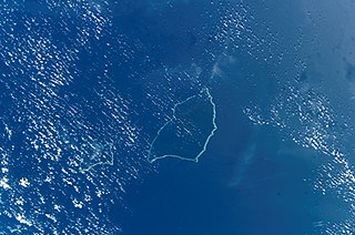
Wotje Atoll is a coral atoll of 75 islands in the Pacific Ocean, and forms a legislative district of the Ratak Chain of the Marshall Islands.

<span class="mw-page-title-main">Maloelap Atoll</span>

The Maloelap Atoll is a coral atoll of 71 islands in the Pacific Ocean, and forms a legislative district of the Ratak Chain of the Marshall Islands. Its land area is only 9.8 square kilometers (3.8 sq mi), but that encloses a lagoon of 972 square kilometers (375 sq mi). It is located 18 kilometers (11 mi) north of the atoll of Aur. The population of the atoll was 395 at the 2021 census.

<span class="mw-page-title-main">Amata Kabua</span> President of the Marshall Islands from 1979 to 1996

Amata Kabua was the first President of the Marshall Islands from 1979 until his death in 1996.

<span class="mw-page-title-main">Likiep Atoll</span>

Likiep Atoll is a coral atoll of 65 islands in the Pacific Ocean, and forms a legislative district of the Ratak Chain of the Marshall Islands. It is approximately 55 kilometers (34 mi) northwest of Wotje. Its total land area is only 10.26 square kilometers (3.96 sq mi), but that encloses a deep central lagoon of 424 square kilometers (164 sq mi). Likiep Atoll also possesses the Marshall Islands' highest point, an unnamed knoll 10 meters (33 ft) above sea level. The population of Likiep Atoll was 228 in 2021.

<span class="mw-page-title-main">Litokwa Tomeing</span> Former President of the Marshall Islands

Iroij Litokwa Tomeing was the President of the Marshall Islands from January 2008 until October 2009.

<span class="mw-page-title-main">Index of Marshall Islands–related articles</span>

The following is an alphabetical list of topics related to the Marshall Islands.

Japanese settlement in the Marshall Islands was spurred on by Japanese trade in the Pacific region. The first Japanese explorers arrived in the Marshall Islands in the late 19th century, although permanent settlements were not established until the 1920s. As compared to other Micronesian islands in the South Seas Mandate, there were fewer Japanese who settled in the islands. After the Japanese surrender in 1945, the Japanese populace were repatriated to Japan, although people of mixed Japanese–Marshallese heritage remained behind. They form a sizeable minority in the Marshall Islands' populace, and are well represented in the corporate, public and political sectors in the country.

<span class="mw-page-title-main">Climate change in Tuvalu</span> Emissions, impacts and responses of Tuvalu related to climate change

Climate change is particularly threatening for the long-term habitability of the island country of Tuvalu, which has a land area of only 26 square kilometres (10 sq mi) and an average elevation of less than 2 metres (6.6 ft) above sea level, with the highest point of Niulakita being about 4.6 metres (15 ft) above sea level. Potential threats to the country due to climate change include rising sea levels, increasingly severe tropical cyclones, high temperatures, and drought.

Anjua Loeak was one of the Iroijlaplap of Ailinglaplap, and one of four paramount chiefs in the Ralik Chain. Loeak shared his domain with the Iroijlaplap of Kwajalein, formerly Imata Kabua.

<span class="mw-page-title-main">Christopher Loeak</span> Marshallese politician

Christopher Jorebon Loeak is a Marshallese politician who was the President of the Marshall Islands from 2012 to 2016. He was elected by parliament as President in January 2012, following the 2011 general election.

<span class="mw-page-title-main">David Kabua</span> Marshallese politician; President of the Marshall Islands (2020-present)

David Kabua is a Marshallese politician who has served as President of the Marshall Islands since 13 January 2020. He has represented Wotho Atoll in the Legislature of the Marshall Islands since 2008 and served terms as Minister of Health and Internal Affairs.

<span class="mw-page-title-main">Hilda Heine</span> Marshallese politician

Hilda Cathy Heine is a Marshallese educator and politician, who served as the eighth President of the Marshall Islands. Prior to assuming office, she served as the Minister of Education. She was the first individual from the Marshall Islands to earn a doctorate degree, and the founder of the women's rights group Women United Together Marshall Islands (WUTMI).

<span class="mw-page-title-main">Delap-Uliga-Djarrit</span> Capital of the Marshall Islands

Delap-Uliga-Djarrit is an urban area in Majuro, the capital and the largest city of the Marshall Islands, with 15,846 people out of Majuro's 23,676. It consists of the districts of Delap, Uliga, and Djarrit. DUD is located on the eastern end of Majuro Atoll. Marshallese government buildings are situated in DUD.

<span class="mw-page-title-main">Effects of climate change on small island countries</span>

The effect of climate change on small island countries can be extreme because of low-lying coasts, relatively small land masses, and exposure to extreme weather. The effects of climate change, particularly sea level rise and increasingly intense tropical cyclones, threaten the existence of many island countries, island peoples and their cultures, and will alter their ecosystems and natural environments. Several Small Island Developing States (SIDS) are among the most vulnerable nations to climate change.

<span class="mw-page-title-main">India–Marshall Islands relations</span> Bilateral relations

India–Marshall Islands relations are the bilateral relations between India and the Marshall Islands. The respective embassies of the two countries in Tokyo, Japan are concurrently accredited to each other. Marshall Islands maintains an Honorary Consulate in New Delhi.

<span class="mw-page-title-main">Naval Base Marshall Islands</span> Major World War II Naval Bases in Marshall Islands

Naval Base Marshall Islands were United States Navy advance bases built on the Marshall Islands during World War II to support the Pacific War efforts. The bases were built by US Navy after the Marshall Islands campaign that captured the islands from the Empire of Japan. By February 1944 the United States Armed Forces had captured the islands. Most of the airfields and other facilities Japan had built were destroyed in allied bombing raids and naval bombardment. US Navy Seabee Construction Battalions arrived as soon as the area was secured and remove the debris. The Seabees quickly repaired, built and improved the airfield/runways and seaport. Seabees often worked around the clock to get airfields operational so that fighter aircraft and bombers could start operating. The bases were used for staging upcoming campaigns and for repair.

References

  1. "Human Rights Measurement Initiative – The first global initiative to track the human rights performance of countries". humanrightsmeasurement.org. Retrieved 2023-05-01.
  2. 1 2 "Marshall Islands - HRMI Rights Tracker". rightstracker.org. Retrieved 2023-05-01.
  3. Climate Change in the Marshall Islands on YouTube American Museum of Natural History
  4. Gillespie and Burns (1999). Climate Change in the South Pacific: Impacts and Responses in Australia, New Zealand, and Small Island States. Kluwewr Academic Publishers. ISBN   0-7923-6077-X.
  5. Davenport, Coral; Haner, Josh (2015-12-01). "The Marshall Islands Are Disappearing". The New York Times. ISSN   0362-4331 . Retrieved 2022-10-07.
  6. "'Nowhere to move': Marshall Islands adapts amid climate change threat". america.aljazeera.com. Retrieved 2022-10-07.
  7. Ford, Murray (2013). "Shoreline changes interpreted from multi-temporal aerial photographs and high resolution satellite images: Wotje Atoll, Marshall Islands". Remote Sensing of Environment. 135: 130–40. Bibcode:2013RSEnv.135..130F. doi:10.1016/j.rse.2013.03.027.
  8. Gilman, Eric; Owens, Matthew; Kraft, Thomas (2014). "Ecological risk assessment of the Marshall Islands longline tuna fishery". Marine Policy. 44: 239–55. doi:10.1016/j.marpol.2013.08.029.
  9. David Kabua (20 September 2020). "The climate crisis will sweep away my country if the world doesn't keep its promises". The Guardian. Retrieved 30 July 2022.
  10. Zak, Dan (2015-11-27). "A ground zero forgotten". Washington Post . Retrieved 2023-10-10.
  11. 1 2 Sutter, John D. "Life in a disappearing country". CNN . Retrieved 2022-10-07.
  12. "Marshall Islands call for "New wave of climate leadership" at upcoming Pacific Islands Forum". Climate & Development Knowledge Network. Retrieved 2022-10-07.
  13. "UN Climate Summit: The Chance to Prove That We Are Climate Leaders". HuffPost. 2014-07-02. Retrieved 2022-10-07.
  14. Rudiak-Gould, Peter (2012). "Promiscuous corroboration and climate change translation: A case study from the Marshall Islands". Global Environmental Change. 22 (1): 46–54. doi:10.1016/j.gloenvcha.2011.09.011.
  15. "Small Islands, Big Impact: Marshall Islands Set Bold Carbon Targets". HuffPost. 2015-07-21. Retrieved 2022-10-07.
  16. "A Clarion Call From the Climate Change Frontline". HuffPost. 2014-09-18. Retrieved 2022-07-23.