Related Research Articles

The Marshall Islands consist of two archipelagic island chains of 30 atolls and 1,152 islands, which form two parallel groups—the "Ratak" (sunrise) chain and the "Ralik" (sunset) chain. The Marshalls are located in the North Pacific Ocean and share maritime boundaries with Micronesia and Kiribati. Two-thirds of the nation's population lives in the capital of Majuro and the settlement of Ebeye. The outer islands are sparsely populated due to lack of employment opportunities and economic development.
The demographics of the Marshall Islands include data such as population density, ethnicity, health of the populace, economic status, religious affiliations and other aspects of the population.

The Marshall Islands is an island country in Oceania.

The government of the Marshall Islands is the largest employer, employing 30.6% of the work force, down by 3.4% since 1988. GDP is derived mainly from payments made by the United States under the terms of the amended Compact of Free Association. Direct U.S. aid accounted for 60% of the Marshall Islands' $90 million budget.
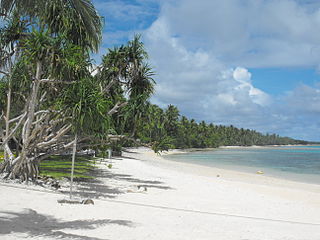
Majuro is the capital and largest city of the Marshall Islands. It is also a large coral atoll of 64 islands in the Pacific Ocean. It forms a legislative district of the Ratak (Sunrise) Chain of the Marshall Islands. The atoll has a land area of 9.7 square kilometers (3.7 sq mi) and encloses a lagoon of 295 square kilometers (114 sq mi). As with other atolls in the Marshall Islands, Majuro consists of narrow land masses. It has a tropical trade wind climate, with an average temperature of 27 °C (81 °F).

The North Island, also officially named Te Ika-a-Māui, is one of the two main islands of New Zealand, separated from the larger but less populous South Island by Cook Strait. With an area of 113,729 km2 (43,911 sq mi), it is the world's 14th-largest island, constituting 44% of New Zealand's land area. It has a population of 3,997,300, which is 77% of New Zealand's residents, making it the most populous island in Polynesia and the 28th-most-populous island in the world.
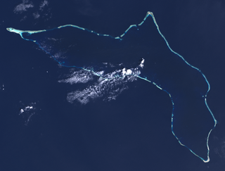
Kwajalein Atoll is part of the Republic of the Marshall Islands (RMI). The southernmost and largest island in the atoll is named Kwajalein Island, which its majority English-speaking residents often use the shortened name, Kwaj. The total land area of the atoll amounts to just over 6 square miles (16 km2). It lies in the Ralik Chain, 2,100 nautical miles southwest of Honolulu, Hawaii.

Ebeye is the most populous island of Kwajalein Atoll in the Marshall Islands, as well as the center for Marshallese culture in the Ralik Chain of the archipelago. Settled on 80 acres of land, it has a population of more than 15,000. Over 50% of the population is estimated to be under the age of 18.

This is a list of hospitals in Oceania for each sovereign state, associated states of New Zealand, and dependencies, and territories. Links to lists of hospitals in countries are used when there are more than a few hospitals in the country. Oceania has an area of 8,525,989 km2 and population of 41,570,842 (2018). The World Health Organization surveys of healthcare in smaller countries are used to identify hospitals in smaller countries.

An urban area, built-up area or urban agglomeration is a human settlement with a high population density and an infrastructure of built environment. This is the core of a metropolitan statistical area in the United States, if it contains a population of more than 50,000.
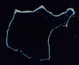
Rongelap AtollRONG-gə-lap is an uninhabited coral atoll of 61 islands in the Pacific Ocean, and forms a legislative district of the Ralik Chain of the Marshall Islands. Its total land area is 8 square miles (21 km2). It encloses a lagoon with an area of 1,000 square miles (2,600 km2). It is historically notable for its close proximity to US hydrogen bomb tests in 1954, and was particularly devastated by fallout from the Castle Bravo test. The population asked the US to move them from Rongelap following the test due to high radiation levels with no success so they asked global environmental group Greenpeace to help. The Rainbow Warrior made four trips moving the islanders, their possessions and their homes to the island of Mejato in the Kwajalein Atoll, 180 kilometers away.
Pacific Islander Americans are Americans who are of Pacific Islander ancestry. For its purposes, the United States census also counts Aboriginal Australians as part of this group.

Bucholz Army Airfield is a United States Army airfield located on Kwajalein Atoll, Marshall Islands. Its position is ideal for refueling during trans-Pacific flights, and the airport is available to civilians through Air Marshall Islands and United Airlines.

The Church of Jesus Christ of Latter-day Saints in the Marshall Islands refers to the Church of Jesus Christ of Latter-day Saints and its members in the Marshall Islands. As of 2022, there were 6,832 members in 13 congregations, making it the second largest body of LDS Church members in Micronesia, behind Kiribati. The Marshall Islands has the second most LDS Church members per capita in Micronesia, and the fourth most members per capita of any independent country in the world, behind Tonga, Samoa, and Kiribati.

Severe Tropical Storm Zelda was the last tropical cyclone of the 1991 Pacific typhoon season; it struck the Marshall Islands on November 28. The area of low pressure that eventually became Zelda formed near the International Date Line, and strengthened into a tropical depression on November 27. The Joint Typhoon Warning Center (JTWC) reported that the depression had reached tropical storm intensity near the Marshall Islands on November 28, thus naming it Zelda. On November 29, the storm quickly strengthened to 65 knots according to the JTWC, equivalent to a Category 1 typhoon on the Saffir–Simpson hurricane wind scale. It reached a peak of 80 kn according to the JTWC, and 60 kn according to the Japanese Meteorological Agency (JMA), with a barometric pressure of 975 hectopascals (28.8 inHg). Zelda weakened into a tropical storm on December 2, and then a tropical depression two days later. The JTWC discontinued warnings late on December 4, while the JMA declared the storm to be extratropical the next day and continued to track until it crossed the International Date Line again on December 7.

Delap-Uliga-Djarrit is an urban area in Majuro, the capital and the largest city of the Marshall Islands, with 15,846 people out of Majuro's 23,676. It consists of the districts of Delap, Uliga, and Djarrit. DUD is located on the eastern end of Majuro Atoll. Marshallese government buildings are situated in DUD.

Naval Base Kwajalein was United States Navy base built on Kwajalein Atoll, in the Marshall Islands to support the World War II efforts in the Pacific War. The base was built after the Battle of Kwajalein ended 3 February 1944. The US Navy built airfields, a seaport and a craft repair depot on the captured islands. The base was part of the vast Naval Base Marshall Islands.