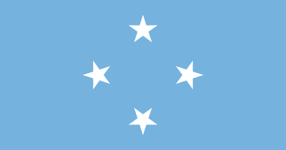
The Federated States of Micronesia, or simply Micronesia, is an island country in Micronesia, a subregion of Oceania. The federation consists of four states—from west to east: Yap, Chuuk, Pohnpei, and Kosrae—that span across the western Pacific just north of the equator, for a longitudinal distance of almost 2,700 km (1,700 mi). Together, the states comprise around 607 islands and a combined land area of approximately 702 km2 or 271 sq mi.

The Federated States of Micronesia are located on the Caroline Islands in the western Pacific Ocean. The history of the modern Federated States of Micronesia is one of settlement by Micronesians; colonization by Spain, Germany, and Japan; United Nations trusteeship under United States-administered Trust Territory of the Pacific Islands; and gradual independence beginning with the ratification of a sovereign constitution in 1979.

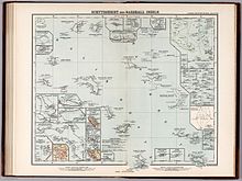
The Marshall Islands, officially the Republic of the Marshall Islands, is an island country west of the International Date Line and north of the equator in the Micronesia region of the Northwestern Pacific Ocean.

Micronesia is a subregion of Oceania, consisting of approximately 2,000 small islands in the Northwestern Pacific Ocean. It has a close shared cultural history with three other island regions: Maritime Southeast Asia to the west, Polynesia to the east, and Melanesia to the south—as well as with the wider community of Austronesian peoples.
The Trust Territory of the Pacific Islands (TTPI) was a United Nations trust territory in Micronesia administered by the United States from 1947 to 1994. The Imperial Japanese South Seas Mandate had been seized by the US during the Pacific War, as Japan had administered the territory since the League of Nations gave Japan a mandate over the area from Imperial Germany after World War I. However, in the 1930s, Japan left the League of Nations and invaded additional lands. During World War II, military control of the islands was disputed, but by the war's end, the islands had come under the Allies' control. The Trust Territory of the Pacific was created to administer the islands as part of the United States while still under the auspices of the United Nations. Most of the island groups in the territory became independent states, with some degree of ties kept with the United States: the Federated States of Micronesia, Marshall Islands and Palau are today independent states in a Compact of Free Association with the US, while the Northern Mariana Islands remain under US jurisdiction, as an unincorporated territory and commonwealth.
Austronesian settlers arrived in the Marshall Islands in the 2nd millennium BC, but there are no historical or oral records of that period. Over time, the Marshallese people learned to navigate over long ocean distances by walap canoe using traditional stick charts.
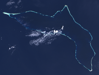
Majuro is the capital and largest city of the Marshall Islands. It is also a large coral atoll of 64 islands in the Pacific Ocean. It forms a legislative district of the Ratak (Sunrise) Chain of the Marshall Islands. The atoll has a land area of 9.7 square kilometers (3.7 sq mi) and encloses a lagoon of 295 square kilometers (114 sq mi). As with other atolls in the Marshall Islands, Majuro consists of narrow land masses. It has a tropical trade wind climate, with an average temperature of 27 °C (81 °F).
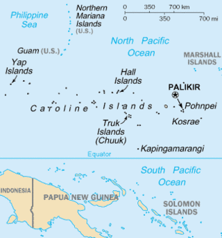
The Caroline Islands are a widely scattered archipelago of tiny islands in the western Pacific Ocean, to the north of New Guinea. Politically, they are divided between the Federated States of Micronesia (FSM) in the central and eastern parts of the group, and Palau at the extreme western end. Historically, this area was also called Nuevas Filipinas or New Philippines, because they were part of the Spanish East Indies and were governed from Manila in the Philippines.
Kwajalein Atoll is part of the Republic of the Marshall Islands (RMI). The southernmost and largest island in the atoll is named Kwajalein Island, which its majority English-speaking residents often use the shortened name, Kwaj. The total land area of the atoll amounts to just over 6 square miles (16 km2). It lies in the Ralik Chain, 2,100 nautical miles southwest of Honolulu, Hawaii.

Iroijlaplap Amata Kabua was the first President of the Marshall Islands from 1979 until his death in 1996.

Ebon Atoll is a coral atoll of 22 islands in the Pacific Ocean, forming a legislative district of the Ralik Chain of the Marshall Islands. Its land area is 5.75 square kilometers (2.22 sq mi), and it encloses a deep lagoon with an area of 104 square kilometers (40 sq mi). A winding passage, the Ebon Channel, leads to the lagoon from the southwest edge of the atoll. Ebon Atoll is approximately 155 kilometers (96 mi) south of Jaluit, and it is the southernmost land mass of the Marshall Islands, on the southern extremity of the Ralik Chain. In documents and accounts from the 1800s, it was also known as Boston, Covell's Group, Fourteen Islands, and Linnez.

Bikar Atoll is an uninhabited atoll in the Ratak Chain of the Marshall Islands. It is one of the smallest atolls in the Marshalls. Due to its relative isolation from the main islands in the group, Bikar's flora and fauna has been able to exist in a relatively pristine condition.

Chuuk State is one of the four states of the Federated States of Micronesia (FSM). It consists of several island groups: Nomoneas, Faichuuk, the Hall Islands, Namonuito Atoll, Pattiw, and the Mortlock Islands. Chuuk is by far the FSM's most populous state, with 50,000 inhabitants on 120 square kilometers. Chuuk Lagoon is where most people live. Weno island, in the lagoon, is Chuuk's state capital and the country's biggest city. It may hold a referendum on independence in the near future, although this referendum has been repeatedly postponed.
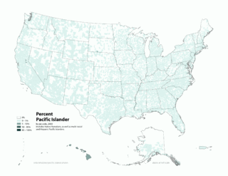
Pacific Islander Americans are Americans who are of Pacific Islander ancestry. For its purposes, the United States census also counts Aboriginal Australians as part of this group.

Toke Atoll or Taka Atoll is a small, uninhabited coral atoll in the Ratak Chain of the Marshall Islands. It is one of the smaller atolls in the Marshalls and located at 11°17′N169°37′E. It is visited regularly by the residents of nearby Utirik Atoll.
Japanese settlement in the Marshall Islands was spurred on by Japanese trade in the Pacific region. The first Japanese explorers arrived in the Marshall Islands in the late 19th century, although permanent settlements were not established until the 1920s. As compared to other Micronesian islands in the South Seas Mandate, there were fewer Japanese who settled in the islands. After the Japanese surrender in 1945, the Japanese populace were repatriated to Japan, although people of mixed Japanese–Marshallese heritage remained behind. They form a sizeable minority in the Marshall Islands' populace, and are well represented in the corporate, public and political sectors in the country.
The nationality law of the Federated States of Micronesia determines who is or may become a citizen or national of the Federated States of Micronesia (FSM). Article III of the Constitution of the Federated States of Micronesia provides the basis for nationality law, while specific provisions are elaborated in 7 FSMC § 201 et seq.

William Vincent "Vit" Vitarelli, also referred to as Rubak in Palau, was an American educator and architect. He worked for the Trust Territory of the Pacific Islands (TTPI) from 1948 to 1970. He was stationed in various islands in Micronesia, including Palau and Ebeye, and participated in various educational and community development projects.
Iroij Namo Hermios was a Marshallese chief and politician. He served as a member of the House of Representatives of the Trust Territory of the Pacific Islands between 1965 and 1968, and as a member of the Marshall Islands Legislature until his death.
Marshallese nationality law is regulated by the Marshallese Constitution of 1979, as amended; the 1984 Citizenship Act of the Marshall Islands, and its revisions; and international agreements entered into by the Marshallese government. These laws determine who is, or is eligible to be, a national of the Marshall Islands. The legal means to acquire nationality, formal membership in a nation, differ from the domestic relationship of rights and obligations between a national and the nation, known as citizenship. Marshallese nationality is typically obtained either on the principle of jus soli, i.e. by birth in the Marshall Islands or under the rules of jus sanguinis, i.e. by birth abroad to parents with Marshallese nationality. It can be granted to persons with an affiliation to the country, or to a permanent resident who has lived in the country for a given period of time through naturalization.