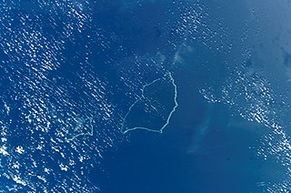
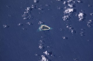
Mejit (Marshallese: Mājej, [mʲæzʲɛːtʲ],[1] or Mājeej, [mʲæzʲɛːtʲ][2]) is an island in the Pacific Ocean, and forms a legislative district of the Ratak Chain of the Marshall Islands. Unlike most of the other islands of the Marshall Islands, Mejit is a stony island rather than a coral atoll, although it is surrounded by a fringing coral reef enclosing a narrow lagoon. It is located east of the main line of the Ratak chain, approximately 110 kilometers (68mi) northeast from Wotje. The population was 230 at the 2021 census.[3]
The island is lush in pandanus, breadfruit and taro. To the residents, this island is known as 'Paradise". It has a freshwater lake (rare in the Marshall Islands) with indigenous ducks. Mejit is famous for its pandanus leaf mats.
First recorded sighting by Europeans was by the Spanish expedition of Miguel López de Legazpi on 9 January 1565. It was charted as Los Barbudos (The Bearded in Spanish) because of the long beards of its inhabitants. Its sighting was also recorded by the Spanish expedition of Ruy López de Villalobos on December 1542.[4]
The German navigator Otto von Kotzebue, sailing in Russian service, made landfall at Mejit Island on January 1, 1817, and named it New Year's Island.[5] In 1885, Mejit was claimed by the German Empire along with the rest of the Marshall Islands.[6] After World War I, the island came under the South Seas Mandate of the Empire of Japan. The island was recovered from the Japanese by U.S. Forces on 2 April 1944. Following the end of World War II, it came under the control of the United States as part of the Trust Territory of the Pacific Islands until the independence of the Marshall Islands in 1986.
The Ratak Chain is a chain of islands and atolls within the island nation of the Marshall Islands. Ratak means "sunrise". It lies to the east of the country's other island chain, the Ralik Chain. In 1999, the total population of the Ratak islands was 30,925.
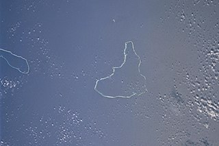
Wotje Atoll is a coral atoll of 75 islands in the Pacific Ocean, and forms a legislative district of the Ratak Chain of the Marshall Islands.
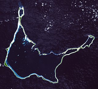
The Maloelap Atoll is a coral atoll of 71 islands in the Pacific Ocean, and forms a legislative district of the Ratak Chain of the Marshall Islands. Its land area is only 9.8 square kilometers (3.8 sq mi), but that encloses a lagoon of 972 square kilometers (375 sq mi). It is located 18 kilometers (11 mi) north of the atoll of Aur. The population of the atoll was 395 at the 2021 census.
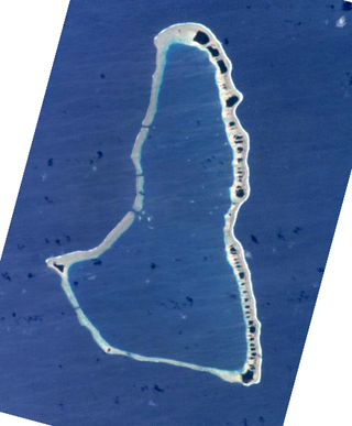
Ailinglaplap or Ailinglapalap is a coral atoll of 56 islands in the Pacific Ocean, and forms a legislative district of the Ralik Chain in the Marshall Islands. It is located 152 kilometres (94 mi) northwest of Jaluit Atoll. Its total land area is only 14.7 square kilometers (5.7 sq mi), but it encloses a lagoon of 750 square kilometers (290 sq mi). The economy of the atoll is dominated by coconut plantations. The population of the atoll was 1,175 in 2021. Jabat Island is located off the coast of Ailinglaplap Atoll. The former president of the Marshall Islands, Kessai Note, was born on Jeh Island, Ailinglaplap Atoll.
Arno Atoll is a coral atoll of 133 islands in the Pacific Ocean, and forms a legislative district of the Ratak Chain of the Marshall Islands. Its total land area is only 5 square miles (13 km2). Unlike most other atolls, Arno encloses three different lagoons, a large central one, and two smaller ones in the north and east. Its main lagoon encloses an area of 130.77 square miles (338.7 km2). At a distance of only 20 kilometers (12 mi), it is the closest atoll to the Marshall Islands capital, Majuro Atoll, and can be seen looking east from Majuro on a clear day at low tide. The population of Arno Atoll was 1,141 at the 2021 census. The most populous islets are Ajeltokrok, Kobjeltak, Rearlaplap, Langor and Tutu. The largest village is Ine, Arno.
Wotho Atoll is a coral atoll of 13 islands in the Pacific Ocean, and forms a legislative district of the Ralik Chain of the Marshall Islands. Its total land area is only 4.33 square kilometers (1.67 sq mi), but it encloses a lagoon of 94.92 square kilometers (36.65 sq mi). The name "Wotho" means either "entrance through the reef", or "island far away" according to different sources.
Ailuk Atoll is a coral atoll of 57 islets in the Pacific Ocean, and forms a legislative district of the Ratak Chain of the Marshall Islands. It is located approximately 72 kilometers (45 mi) north from Wotje. Its total land area is only 5.4 square kilometers (2.1 sq mi), but it encloses a lagoon with an area of 177.45 square kilometers (68.51 sq mi). The major islets are: Ajelep, Aliej, Ailuk, Alkilwe, Barorkan, Biken, Enejabrok, Enejelar, Kapen and Marib. Most of the islets are on the eastern side of the atoll. The western and southern sides of the atoll have a nearly continuous submerged coral reef, with three main passes that lead into the lagoon: Erappu Channel, Marok Channel and Eneneman Channel on the west side.
Aur Atoll is a coral atoll of 42 islands in the Pacific Ocean, and forms a legislative district of the Ratak Chain of the Marshall Islands. Its total land area is only 15 square kilometers (5.6 sq mi), but it encloses a lagoon with an area of 620 square kilometers (240 sq mi). It is located south of Maloelap Atoll. The population of Aur Atoll was 317 in 2021.
Jabat Island is an island in the Pacific Ocean, and forms a legislative district of the Ralik Chain of the Marshall Islands. Its total land area is only 0.6 square kilometers (0.23 sq mi), and has a length of 1.2 kilometers (0.75 mi). It is located 12 kilometers (7.5 mi) from Ailinglapalap Atoll. Unlike most of the other islands in the Marshall Islands, Jabat Island is a rocky island rather than a coral atoll, although it surrounded by fringing shallow water coral reefs that extend for several kilometres beyond the outer reef to the north and south. The population of Jabat Island was 75 in 2021.
Lae Atoll is a coral atoll of 20 islands in the Pacific Ocean, and forms a legislative district of the Ralik Chain of the Marshall Islands. Its total land area is only 1.5 square kilometers (0.58 sq mi), but it encloses a lagoon with an area of 17.7 square kilometers (6.8 sq mi). It is located approximately 47 kilometers (29 mi) east of Ujae Atoll. The population of Lae Atoll was 133 in 2021. Its islands include Lae, Looj (Lotj), Bilalalon, Riblong (Ribon) and Lweijab (Lejab).
Likiep Atoll is a coral atoll of 65 islands in the Pacific Ocean, and forms a legislative district of the Ratak Chain of the Marshall Islands. It is approximately 55 kilometers (34 mi) northwest of Wotje. Its total land area is only 10.26 square kilometers (3.96 sq mi), but that encloses a deep central lagoon of 424 square kilometers (164 sq mi). Likiep Atoll also possesses the Marshall Islands' highest point, an unnamed knoll 10 meters (33 ft) above sea level. The population of Likiep Atoll was 228 in 2021.
Ujae Atoll is a coral atoll of 15 islands in the Pacific Ocean, and forms a legislative district of the Ralik Chain of the Marshall Islands. Its total land area is only 1.86 square kilometers (0.72 sq mi), but it encloses a lagoon of 185.94 square kilometers (71.79 sq mi). It is located about 122 kilometers (76 mi) west of Kwajalein Atoll.
Utirik Atoll or Utrik Atoll is a coral atoll of 10 islands in the Pacific Ocean, and forms a legislative district of the Ratak Chain of the Marshall Islands. Its total land area is only 2.4 square kilometers (0.94 sq mi), but it encloses a lagoon with an area of 57.7 square kilometers (22.29 sq mi). It is located approximately 47 kilometers (29 mi) east of Ujae Atoll. The population of Utirik Atoll was 264 at the 2021 census. It is one of the northernmost Marshall Islands with permanent habitation.
Ujelang Atoll is an uninhabited coral atoll of 30 islands in the Pacific Ocean, in the Ralik Chain of the Marshall Islands. Its total land area is 1.86 square kilometers (0.72 sq mi), and it encloses a lagoon of 185.94 square kilometers (71.79 sq mi). It is the westernmost island in the Marshall Islands, approximately 217 kilometers (135 mi) southeast of Enewetak, and approximately 600 kilometers (370 mi) west of the main Ralik Chain.
Namu Atoll is a coral atoll of 54 islands in the Pacific Ocean, and forms a legislative district of the Ralik Chain of the Marshall Islands. Its total land area is only 6.27 square kilometers (2.42 sq mi), but that encloses a lagoon of 397 square kilometers (153 sq mi). It is located approximately 62 kilometers (39 mi) south-southwest of Kwajalein Atoll.
Bikar Atoll is an uninhabited atoll in the Ratak Chain of the Marshall Islands. It is one of the smallest atolls in the Marshalls. Due to its relative isolation from the main islands in the group, Bikar's flora and fauna has been able to exist in a relatively pristine condition.
Jemo Island Atoll is an uninhabited coral island in the Pacific Ocean, in the Ratak Chain of the Marshall Islands north-east of Likiep Atoll. The island is oval-shaped and occupies the southwestern end of a narrow submarine ridge that extends to the northeast for several kilometers. Its total land area is only 0.16 square kilometers (0.062 sq mi). The island is traditionally held as a food reserve for the family of Joachim and Lijon deBrum, passed down to Lijon debrum from Iroijlaplap Lobareo and is owned by the current Likiep land-owning families of Joachim and Lijon debrum, grandkids of Iroijlaplap Jortõka of Ratak Eañ. There is also a shipwreck of unknown origin on the west side of the island.
Erikub Atoll is an uninhabited coral atoll of fourteen islands in the Pacific Ocean, located in the Ratak Chain of the Marshall Islands. Its total land area is only 1.53 square kilometers (0.59 sq mi), but it encloses a lagoon with an area of 230 square kilometers (89 sq mi). It is located slightly south of Wotje.
Knox Atoll is an uninhabited coral atoll of 18 islands in the Pacific Ocean, and is the southernmost atoll of the Ratak Chain of the Marshall Islands. The total land area is only 0.98 square kilometers (0.38 sq mi), but it encloses a largely sand-filled lagoon with an area of 3.42 square kilometers (1.32 sq mi). The atoll measures 11 kilometers (6.8 mi) in length and is 2 kilometers (1.2 mi) wide. The largest islets, located on the western and northern sides, include Aelingeo, Nadikdik and Nariktal. The atoll is separated by the Klee Passage from the southern point of Mili Atoll to which it was once connected.
Toke Atoll or Taka Atoll is a small, uninhabited coral atoll in the Ratak Chain of the Marshall Islands. It is one of the smaller atolls in the Marshalls and located at 11°17′N169°37′E. It is visited regularly by the residents of nearby Utirik Atoll.
This page is based on this Wikipedia article Text is available under the CC BY-SA 4.0 license; additional terms may apply. Images, videos and audio are available under their respective licenses.